Hardley Flood
| Site of Special Scientific Interest | |
 | |
| Area of Search | Norfolk |
|---|---|
| Grid reference | TM 380 996[1] |
| Interest | Biological |
| Area | 49.8 hectares (123 acres)[1] |
| Notification | 1990[1] |
| Location map | Magic Map |
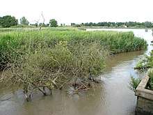
Hardley Flood is a 49.8-hectare (123-acre) biological Site of Special Scientific Interest west of Great Yarmouth in Norfolk.[1][2] It is part of the Broadland Ramsar site[3] and Special Protection Area,[4] and The Broads Special Area of Conservation.[5]
This area of tidal lagoons and reedbeds provides a spillway for the River Chet. The reedbeds provide nesting sites for birds, including nationally important populations of several breeding birds. Three rare flies have been recorded, Elachiptera uniseta, Elachiptera scrobiculata and Lonchoptera scutellata.[6]
The site is open to the public.
References
- 1 2 3 4 "Designated Sites View: Hardley Flood". Sites of Special Scientific Interest. Natural England. Retrieved 12 June 2018.
- ↑ "Map of Hardley Flood". Sites of Special Scientific Interest. Natural England. Retrieved 12 June 2018.
- ↑ "Designated Sites View: Broadland". Ramsar Sites. Natural England. Retrieved 25 May 2018.
- ↑ "Designated Sites View: Broadland". Special Protection Areas. Natural England. Retrieved 25 May 2018.
- ↑ "Designated Sites View: The Broads". Special Areas of Conservation. Natural England. Retrieved 25 May 2018.
- ↑ "Hardley Flood citation" (PDF). Sites of Special Scientific Interest. Natural England. Retrieved 12 June 2018.
| Wikimedia Commons has media related to Hardley Flood. |
This article is issued from
Wikipedia.
The text is licensed under Creative Commons - Attribution - Sharealike.
Additional terms may apply for the media files.