Public transport in Sydney
| Map of the major infrastructure in Transport for NSW's Sydney passenger public transport network. | |
| Colours: train=orange, bus=blue, ferry=green, light rail=red. | |


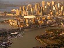
Public transport in Sydney is provided by an extensive network of operating modes including suburban rail, light rail, buses and ferries. The network will also include a mode of rapid transit, with the new Sydney Metro opening in early 2019. According to the 2006 census, in terms of travel to work or study Sydney has the highest rate of public transport usage among the Australian capital cities of 26.3% with more than 80% of weekday trips to/from Central Sydney being made by public transport.[1] According to the New South Wales State Plan, the state has Australia's largest public transport system. The network is regulated by Transport for NSW.
Sydney's early urban sprawl can be traced in part to the development of its passenger rail network.[2] The first rail services began in 1855, 67 years after the settlement's foundation and a tram network which began in 1861, becoming the Southern Hemisphere's largest by the 1920s. This rail infrastructure allowed working-class suburbs to develop at a large distance from the city centre.[2] In terms of effectiveness and sustainability of public transport, Sydney lagged behind Brisbane and many other cities in a 2017 study by design firm Arcadis, where it was ranked at 51.[3][4]
Ticketing
Transport for NSW public transport services use the Opal ticketing system. The rollout of this contactless system started in December 2012 and completed in December 2014. The previous generation of ticketing products were withdrawn in August 2016.
Fares are controlled by the Independent Pricing and Regulatory Tribunal of New South Wales. As of January 2009, Sydney public transport prices were slightly higher than in other mainland Australian cities.[5]
Bus
Commuter bus services account for about half of the public transport journeys taken in the city on weekdays. Of the 921,000 weekday bus trips, 554,000 are provided by the State Transit Authority, a government authority, the remainder by a number of private-sector operators.[6]
East of Strathfield, the majority of the bus network replaces the city's former tram network. State Transit operates a network tightly integrated with train and ferry services in the Eastern, Northern and North-Western regions of Sydney. In other areas services are operated by private-sector companies under contract to the NSW Government authority Transport for NSW. Under pressure from bus contracting reforms, many of the private bus companies have merged or entered into joint ventures. The largest private bus operator is ComfortDelGro Australia, owners of Hillsbus. Other significant players include Punchbowl Bus Company, Busways,Transdev NSW and Transit Systems
Bus services in the regions surrounding Sydney are considered part of the metropolitan network. Outer-metropolitan services are provided by the private sector under contract to Transport for NSW. Here, ComfortDelGro Cabcharge, Busways and Premier Illawarra are significant players.
Network
Sydney's bus network has been divided into different regions. Of these regions, bus routes are classified with three-digit route numbers.
Currently, Sydney has two operating T-Ways:
- The Liverpool-Parramatta T-way opened in 2003
- The North-West T-way opened in 2007
Additional bus networks operate in the Outer Sydney region, which include:
- Blue Mountains
- Central Coast
- Illawarra
- Newcastle
Rail
.jpg)
Heavy rail
.jpg)


Suburban rail services within Sydney are provided by Sydney Trains. Sydney's suburban commuter rail service consists of a complex system of integrated railway lines, of which most run through the city underground. All city trains consist of eight double deck carriages with two crew members on board–driver and guard. Fares are calculated on the basis of distance travelled. Trains run from 4am until around 1am seven days a week with Nightride bus services covering the network throughout the night when trains are not operating.
Sydney Metro is a new rapid transit line that will run from Sydney's north-western suburbs, pass through the city and then travel south-west to Bankstown.
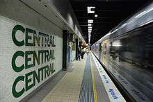
NSW TrainLink interurban trains operate from Central railway station to the Illawarra, Southern Highlands, Blue Mountains, Central Coast and Newcastle. This station is also the terminus for NSW TrainLink's long distance trains to numerous destinations in country New South Wales as well as Melbourne and Brisbane. The Indian Pacific also operates to Adelaide and Perth.
Trams and light rail
Sydney once had the Southern Hemisphere's largest tram network. Patronage peaked in 1945 at 405 million passenger journeys. The system was in place from 1861 until its winding down in the 1950s and eventual closure in 1961. It had a maximum street mileage of 291 km (181 miles) in 1923. A short heritage tramway operated by the Sydney Tramway Museum has linked Loftus railway station and the Royal National Park since the 1990s.
In 1997, a short light rail line between Central and Pyrmont opened, now known as the Dulwich Hill Line. The line was extended twice and is now 12.8 km long. A second line, passing through Sydney's CBD from Circular Quay to Randwick and Kingsford is currently under construction. It is scheduled to open in 2019. There is also a planned line running from Westmead station to Carlingford via Parramatta station, reusing part of the old single tracked Carlingford line. The line is due to open in 2023. A second line is also proposed to branch from Camelia to Strathfield via Sydney Olympic Park. The Parramatta light rail lines will have no connection to the Inner West light rail or the CBD and South East light rail lines.
Punctuality
The punctuality of Sydney's rail network has been highlighted, and an April 2017 news report stated that "The punctuality of intercity trains lags behind suburban trains, and there was an extended period of declining punctuality between 2011 and 2014".[7]
Ferry
Sydney Ferries
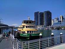
Sydney Ferries runs numerous commuter and tourist ferries on Sydney Harbour and the Parramatta River. Harbour ferries are used in equal measure by commuter and leisure users; Parramatta River ferries are overwhelmingly used for leisure and tourist trips. Sydney Ferries operates nine routes, with approximately 14,000,000 passengers per year.[8] Sydney Ferries operates from Circular Quay Ferry Terminal, a major transport hub in Sydney's central business district, with popular routes including services to the beachside suburb of Manly and to Taronga Zoo, a major tourist attraction. Sydney Ferries also operates sightseeing cruises for tourists.
Other passenger ferry operators
Several private sector companies run passenger ferries in the Sydney region. These include:
- Church Point Ferry, from Church Point to Scotland Island
- Cronulla and National Park Ferry, from Cronulla to Bundeena
- Dangar Island Ferries, from Brooklyn to Dangar Island
- Captain Cook Cruises, from Circular Quay to Darling Harbour, Lane Cove and hop On/Hop Off loop service to Taronga Zoo, Watsons Bay, etc.
- Palm Beach Ferry, from Palm Beach to Great Mackerel Beach and the Basin, and to Ettalong Beach and Wagstaffe
- Palm Beach & Hawkesbury River Cruises, from Palm Beach to Patonga
Vehicle ferries
Several car ferries form part of Sydney's road system. These ferries are controlled by a combination of the Roads and Maritime Services and local government, and are toll-free. They include:
- Berowra Waters Ferry, across Berowra Creek
- Lower Portland Ferry, across the Hawkesbury River
- Mortlake Ferry, across the Parramatta River
- Webbs Creek Ferry, across the Hawkesbury River
- Wisemans Ferry, across the Hawkesbury River
- Sackville Ferry, across the Hawkesbury River
Sydney Public Transportation Statistics
The average amount of time people spend commuting with public transit in Sydney, for example to and from work, on a weekday is 82 min. 31% of public transit riders, ride for more than 2 hours every day. The average amount of time people wait at a stop or station for public transit is 13 min, while 18% of riders wait for over 20 minutes on average every day. The average distance people usually ride in a single trip with public transit is 9 km, while 21% travel for over 12 km in a single direction. [9]
Patronage
The 2010s have seen major investment in Sydney's public transport infrastructure. The introduction of a metro network and a significant expansion of light rail will lead to a substantial change in the city's modal mix as these projects are completed.
 Train |
345 443 000 | 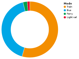 |
 Bus |
264 305 000 | |
 Ferry |
15 328 000 | |
 Light rail |
9 320 000 |
See also
References
- ↑ "4102.0 - Australian Social Trends, 2008". Australian Bureau of Statistics. 23 July 2008. Retrieved 6 April 2013.
- 1 2 Forster, Clive 1996 Australian Cities: Continuity and Change. Oxford University Press
- ↑ "Sydney's transport network lags Brisbane in global rankings". Sydney Morning Herald. 30 October 2017. Retrieved 2 November 2017.
- ↑ "Australian cities lag behind on key global competitiveness measure". News.com.au. 30 October 2017. Retrieved 2 November 2017.
- ↑ Public Transport Users Association. "Fare Comparison". PTUA Survey. Retrieved 29 January 2012.
- ↑ 2000 "Bus Users in Sydney" Report from the Transport Data Centre, part of Transport NSW Archived 27 March 2011 at the Wayback Machine. – provides state & private bus trips taken, total derived from that. "About Transport in New South Wales" page from Transport NSW Archived 27 March 2011 at the Wayback Machine. – provides total trips taken (about 2 million), "about half" derived from that and total bus trips taken. "Archived copy". Archived from the original on 27 March 2011. Retrieved 18 February 2013.
- ↑ "Rail network needs to avoid peak crunch by 2019". govnews.com.au. April 2017.
- ↑ "Sydney Ferries". Transport for NSW. 7 December 2012. Retrieved 18 February 2013.
In 2011-12, 173,329 ferry services were scheduled, carrying 14.7 million passengers.
- ↑ "Sydney Public Transportation Statistics". Global Public Transit Index by Moovit. Retrieved June 19, 2017.

- ↑ See Transport for NSW patronage in Sydney by mode for sources
External links
- NSW TransportInfo – comprehensive information on trains, buses and ferries.
- NSW Bike Plan – Bicycle Information for New South Wales