Cronulla, New South Wales
| Cronulla Sydney, New South Wales | |||||||||||||||
|---|---|---|---|---|---|---|---|---|---|---|---|---|---|---|---|
 Cronulla, New South Wales | |||||||||||||||
| Population | 18,070 (2016 census)[1] | ||||||||||||||
| Established | 1908 | ||||||||||||||
| Postcode(s) | 2230 | ||||||||||||||
| Location | 26 km (16 mi) south of Sydney CBD | ||||||||||||||
| LGA(s) | Sutherland Shire | ||||||||||||||
| State electorate(s) | Cronulla | ||||||||||||||
| Federal Division(s) | Cook | ||||||||||||||
| |||||||||||||||

Cronulla is a beachside suburb of Sydney, in the state of New South Wales, Australia. Boasting numerous surf beaches and swimming spots, the suburb attracts both tourists and Greater Sydney residents. Cronulla is located 26 kilometres south of the Sydney central business district, in the local government area of the Sutherland Shire.
Cronulla is located on a peninsula framed by Botany Bay to the north, Bate Bay to the east, Port Hacking to the south, and Gunnamatta Bay to the west. The neighbouring suburb of Woolooware lies to the west of Cronulla, and Burraneer lies to the southwest. The Kurnell peninsula, the site of the first landfall on the eastern coastline made by Captain James Cook in 1770, is reached by driving northeast out of Cronulla on Captain Cook Drive.
History
Cronulla is derived from kurranulla, meaning ‘‘place of the pink seashells’’ in the dialect of the area's Aboriginal inhabitants, the Gweagal, who were a clan of the Tharawal (or Dharawal) tribe of Indigenous Australians. They Inhabited the southern geographic areas of Sydney. The beaches were named by Surveyor Robert Dixon who surveyed here in 1827-28 and, by 1840, the main beach was still known as Karranulla.[2] In July 1852 the schooner Venus was wrecked on the beach, which was referred to in newspaper reports as Cooranulla.[3]
Matthew Flinders and George Bass explored and mapped the coastline and Port Hacking estuary in 1796 and the southernmost point of Cronulla is named Bass and Flinders Point in their honour. John Connell received a grant of 380 acres (1.5 km2) in 1835. Thomas Holt (1811–88) owned most of the land that stretched from Sutherland to Cronulla in the 1860s. Holt built Sutherland House on the foreshore of Gwawley Bay in 1818, on the eastern side of Sylvania. In 1888 master mariner Captain Joseph Henry Rounce Spingall became the pioneering resident of Cronulla when, with his family, he constructed the two storey 'Oriental Guest House' on land above where today's North Cronulla Hotel sits. The Depression of 1890 and a lack of reliable transport access from Sutherland saw "The Captain's" pub sold. The Cronulla area was subdivided in 1895 and land was offered for sale at 10 pounds per acre. In 1899, the government named the area Gunnamatta, which means sandy hills. On 26 February 1908, it was officially changed to Cronulla and Gunnamatta was used for the name of the bay, on the western side.
After the Illawarra railway line was built to Sutherland in 1885, the area became popular for picnics and swimming. Steam trams operated between Cronulla and Sutherland from 1911. Many regulars rented beach houses at Cronulla every year for school holidays. The Oriental Hotel was built by Captain Spingall in 1888, on the present site of apartments behind the North Cronulla Hotel. The Cecil Hotel was located on the foreshore of South Cronulla and the Ritz Café was popular with holiday-makers. The Cecil Apartments were built on the former site of this hotel. The steam trams were replaced by the Cronulla branch of the Illawarra railway line when it opened in 1939.[4]
The post office opened in January 1891, known as Cronulla Beach, but closed in 1893. It reopened in 1907 and the name was officially changed to Cronulla in 1929. The Cronulla School of Arts was established in 1904. The original wooden building was demolished and replaced by the current School of Arts building in November 1912 and is now one of the oldest buildings in Cronulla.
The first public school opened in 1910. In 1955, Cronulla Library opened.[5] From the 1950s, many of the guest houses began being replaced by high rise flats. Even though it developed as a residential area, Cronulla remained popular with beachgoers and tourists. Several hotels, motels and serviced apartments operate today. The Cronulla Bicentennial Plaza opened in February 1989.
In 2005 the beachfront at Cronulla was the scene of widely publicised mob disturbances and violent confrontations.[6] These incidents continued over a number of days and also spread to other areas in Sydney.[7]
Heritage listings
Cronulla has a number of heritage-listed sites, including:
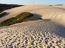
- Captain Cook Drive: Cronulla sand dunes[8]
- Cronulla railway: Cronulla railway station[9]
- 41 Cronulla Street: Cronulla Post Office[10]
- 202 Nicholson Parade: Cronulla Fisheries Centre[11]
Beaches
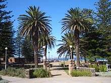
Cronulla is a popular tourist attraction and attracts many beachgoers from all over Sydney. Cronulla Beach features a long stretch of sand that runs from Boat Harbour to North Cronulla, followed by rock pools and another sandy beach at South Cronulla. The beaches of Cronulla from north to south are: Boat Harbour, Wanda Beach, Elouera Beach, North Cronulla Beach, Cronulla Beach, Blackwoods Beach, Shelly Beach and Oak Park. Local names also apply to various parts of the beach, such as The Alley, between Cronulla Beach and North Cronulla, The Wall, between North Cronulla and Elouera, Midway, between Elouera and Wanda, and Greenhills, to the north of Wanda, Sandshoes, near the mouth of the Port Hacking estuary, Voodoo Reef and The Point. The beaches are popular recreational areas for swimming, surfing, bodyboarding, bodysurfing and other water sports.[12]
Shark Island, just off Cronulla Beach, is a famous surfing and bodyboarding spot, and the site of the annual Shark Island Challenge bodyboarding contest. Gunnamatta Bay provides protected swimming at the baths off Gunnamatta Park. Port Hacking is a popular location for such water sports as waterskiing and wakeboarding.
Parks
- Bass & Flinders Point is the southernmost part of Cronulla and features a monument to explorers George Bass and Matthew Flinders, who explored the Port Hacking estuary.
- Darook Park, Gunnamatta Park and Tonkin Park are all located on Gunnamatta Bay.
- Cronulla Park is located behind the beach at South Cronulla.
- Dunningham Park sits behind the beach at North Cronulla, shaded by large Norfolk Island Pines. It features a children's playground, picnic tables and a kiosk.
- Monro Park, featuring the Cronulla War Memorial,[13] is located opposite Cronulla railway station.
- Don Lucas Reserve is located beside the car park at Wanda Beach, popular for sport and recreational activities such as flying kites.
- Shelly Park sits behind Shelley Beach.
Commercial area
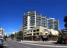
The main shopping strip runs along Cronulla Street, which has been partly converted into a pedestrian mall known as Cronulla Plaza. It also extends along the Kingsway, Gerrale Street and other surrounding streets. Cronulla has developed a café culture, with some cafés and restaurants located along the North Cronulla foreshore and Cronulla Plaza. The suburb boasts a Rydges high-rise hotel, although tourists can choose from a variety of hotels, motels and serviced apartments. Cronulla has many attractions including an GU Filmhouse cinema, restaurants, nightclubs, pubs and bars.
Transport
Trains terminate at Cronulla railway station on the Cronulla branch of the Illawarra line, on the Sydney Trains network. Cronulla Tunnel Gallery is just north of the station, linking Cronulla Street to Tonkin Street.
Cronulla and National Park Ferry Cruises runs passenger services around Port Hacking and a regular route between Cronulla and Bundeena, on the edge of the Royal National Park. The Cronulla Ferry wharf sits on Gunnamatta Bay, beside Tonkin Park.
Transdev NSW operates several bus routes that stop at Cronulla Railway Station. For full details of all bus services see Cronulla Station.
Sport and recreation

- The local National Rugby League football club is the Cronulla-Sutherland Sharks. The Cronulla-Sutherland League's Club and home ground, Endeavour Field, are located on Captain Cook Drive at Woolooware.
- Cronulla-Sutherland Junior Baseball Little League represented Australia in the 2015 Little League World Series where they had a record of one win and two losses.
- Surf lifesaving clubs are located along the beach at Wanda, Elouera, North Cronulla and South Cronulla.
- Many soccer clubs are located in the Cronulla district, the most prominent being Cronulla Seagulls FC and the Cronulla RSL clubs.
- Surfing plays a major role in Cronulla. Famous professional surfer and 1999 world champion Mark Occhilupo ('Occy') grew up surfing in Cronulla. Many surfboard shapers hand craft their surfboards in Cronulla and the Sutherland Shire and Cronulla Beach holds the Australian Boardriders Battle on Australia Day.
- The annual Shark Island Challenge bodyboarding contest and the annual Shark Island Swim Challenge are held at Cronulla Beach.
- The Cronulla International Cycling Grand Prix has been held in Cronulla since 2006. In 2009 it was also the Australian National Criterium Championships.[14][15]
- The Bate Bay Body Bashers are a Bodysurfing club based in Cronulla. They compete in team bodysurfing competitions against other Australian clubs including the East Sydney Bodysurfers and the Northern Beaches Wompers. They were Australian Champions in 2017.[16]
- The Cronulla Polar Bears Winter Swimming Club compete against Bondi Icebergs Winter Swimming Club, South Maroubra Dolphins Winter Swimming Club, Clovelly Eskimos Winter Swimming Club, Maroubra Seals Winter Swimming Club, Coolangatta Surf Life Saving Club, Coogee Penguins Winter Swimming Club, Bronte Splashers, Wollongong Whales and Cottesloe Crabs in the Winter Swimming Association of Australia Championships[17]
Events
- Cronulla Spring Festival is held every year on the second weekend of September. It includes free entertainment, food and many variety stalls.
- Opera On the Beach is an event commonly held at Cronulla as part of the nation's Australia Day celebrations.[18]
Popular culture
- Puberty Blues is a book and movie about the surfing culture in the Sutherland Shire.
- The Australia's Next Top Model (Cycle 4) house was situated on Gunnamatta Bay.
- The Shire, is a reality TV show began being filmed in early 2012, having Cronulla as its main setting.
Population
According to the 2016 census of Population, there were 18,070 people in Cronulla.
- Aboriginal and Torres Strait Islander people made up 1.0% of the population.
- The most common ancestries were English 28.5%, Australian 24.5%, Irish 10.9%, Scottish 7.4% and Italian 3.0%
- 75.1% of people were born in Australia. The most common countries of birth were England 3.6%, New Zealand 1.8%, Philippines 0.6% and Germany 0.6%.
- 82.7% of people only spoke English at home. Other languages spoken at home included Greek 0.9%, Spanish 0.9%, Portuguese 0.7%, Italian 0.7% and German 0.6%.
- The most common responses for religion were Catholic 27.5%, No Religion 27.4% and Anglican 18.2%.
- The median weekly household income was $1,794, higher than the national median of $1,438.
- Of occupied private dwellings in Cronulla, 72.7% were flat or apartments, 20.5% were separate houses and 5.7% were semi-detached.[1]
Notable residents
- Scott Morrison, 30th Prime Minister of Australia
- Luke Baines, actor, singer and model
- Micheal Vincent McHugh, actor and model
- Lara Bingle, model, former partner of cricketer Michael Clarke
- Brendan Cowell, actor, appeared on Love My Way
- Daniel MacPherson, Australian actor, TV presenter, notable for being in City Homicide and Dancing with the Stars
- Chris McCormack, ironman, triathlete
- Craig Alexander, ironman, triathlete
- Toni Pearen, TV presenter, actress
- Myles Pollard, actor, appeared on McLeod's Daughters
- Jason Stevens, former Cronulla-Sutherland Sharks player
- Sharni Vinson, actress, appeared on Home and Away
- Damian Keogh, former Australian basketball captain and CEO of Hoyts cinema group and Val Morgan
Schools
Cronulla is home to a number of primary and secondary schools:
- Cronulla High School
- De La Salle College
- Our Lady of Mercy College
- Cronulla Public School
- South Cronulla Public School
- St Francis De Sales
- Burraneer Bay Public School
- St Aloysius Catholic Primary School
Churches
There are several churches in the Cronulla area:
- St Andrews Anglican Church
- St Aloysius Catholic Church
- Cronulla Baptist Church
- Cronulla Uniting Church
- Presbyterian War Memorial Church
- C3 Church Cronulla
- Establish Church
See also
References
- 1 2 Australian Bureau of Statistics (27 June 2017). "Cronulla (State Suburb)". 2016 Census QuickStats. Retrieved 12 September 2017.

- ↑ http://www.sutherland.nsw.gov.au/ssc/rwpattach.nsf/0/Factsheet_6_FINAL_20030728.pdf/$file/Factsheet_6_FINAL_20030728.pdf Sutherland Shire Place Names Archived 4 October 2006 at the Wayback Machine.
- ↑ Sydney Morning Herald, 30 Jun 1852,p2
- ↑ The Book of Sydney Suburbs, Compiled by Frances Pollon, Angus & Robertson Publishers, 1990, Published in Australia ISBN 0-207-14495-8
- ↑ Watt, Bruce (2014). The Shire : A journey through time. China: Everbest. p. 199. ISBN 9780646920191.
- ↑ "Mob violence envelops Cronulla". AAP. 11 December 2005. Retrieved 31 August 2006.
- ↑ "Now churches are targeted". The Australian. Archived from the original on 8 February 2006. Retrieved 31 August 2006.
- ↑ "Cronulla Sand Dune and Wanda Beach Coastal Landscape, New South Wales State Heritage Register (NSW SHR) Number H01668". New South Wales State Heritage Register. Office of Environment and Heritage. Retrieved 18 May 2018.
- ↑ "Cronulla Railway Station group, New South Wales State Heritage Register (NSW SHR) Number H01123". New South Wales State Heritage Register. Office of Environment and Heritage. Retrieved 18 May 2018.
- ↑ "Cronulla Post Office (Place ID 106203)". Australian Heritage Database. Department of the Environment. Retrieved 23 September 2018.
- ↑ "Cronulla Fisheries Centre, The, New South Wales State Heritage Register (NSW SHR) Number H01011". New South Wales State Heritage Register. Office of Environment and Heritage. Retrieved 18 May 2018.
- ↑ "Cronulla". Sydney.com. Retrieved 12 June 2013.
- ↑ Trembath, Murray (13 April 2018). "Flashback Friday | When Monro Park nearly became a car park". St George & Sutherland Shire Leader. Retrieved 14 April 2018.
- ↑ National Championships awarded to Cronulla Grand Prix Cycling NSW. Retrieved 13 December 2009
- ↑ Daniel Lane McEwen leads pack of cycling aces in race to rebuild shire's reputation Sydney Morning Herald, 26 November 2006. Retrieved 13 December 2009
- ↑ John Veage"Big Win for Bate Bay Body Bashers". www.theleader.com.au. Retrieved 2018-01-18.
- ↑ "My Site". www.wsaainc.com. Retrieved 2018-01-13.
- ↑ "Events & What's Happening". Thursday 26th January 2012. Cronulla Beach YHA Sydney NSW Australia. Retrieved 12 June 2013.
External links
| Wikivoyage has a travel guide for Sydney/Cronulla. |
| Wikimedia Commons has media related to Cronulla, New South Wales. |
Coordinates: 34°03′27″S 151°09′08″E / 34.05744°S 151.15219°E