Pontgibaud
| Pontgibaud | |
|---|---|
| Commune | |
 Panorama de Pontgibaud | |
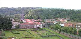
 Pontgibaud Location within Auvergne-Rhône-Alpes region  Pontgibaud | |
| Coordinates: 45°49′59″N 2°51′04″E / 45.833°N 2.851°ECoordinates: 45°49′59″N 2°51′04″E / 45.833°N 2.851°E | |
| Country | France |
| Region | Auvergne-Rhône-Alpes |
| Department | Puy-de-Dôme |
| Arrondissement | Riom |
| Canton | Saint-Ours |
| Government | |
| • Mayor (2008–2014) | Gaston Matarin |
| Area1 | 4.59 km2 (1.77 sq mi) |
| Population (2006)2 | 768 |
| • Density | 170/km2 (430/sq mi) |
| Time zone | UTC+1 (CET) |
| • Summer (DST) | UTC+2 (CEST) |
| INSEE/Postal code | 63285 /63230 |
| Elevation | 639–779 m (2,096–2,556 ft) |
|
1 French Land Register data, which excludes lakes, ponds, glaciers > 1 km2 (0.386 sq mi or 247 acres) and river estuaries. 2 Population without double counting: residents of multiple communes (e.g., students and military personnel) only counted once. | |
Pontgibaud is a commune in the Puy-de-Dôme départment in Auvergne in central France.
It is located in the Massif Central region of France on the banks of the Sioule River. The area around the town was historically known for silver and lead mining. The Société des mines et fonderies de Pontgibaud exploited the lead-silver mines between 1852 and 1897.
The remnants of Château-Dauphin, a 12th-century castle, are located in Pontgibaud.
John Ruskin spent October 7th 1840 exploring Pontgibaud. He reckoned it "Altogether the happiest day, as far as employment or scenery can go, I have had for these long five years".[1]
See also
References
- ↑ The Dairies of John Ruskin. Selected and edited by Joan Evans and John Howard Whitehouse. Vol 1. (1835 to 1847). Oxford at The Clarendon Press. 1956.
| Wikimedia Commons has media related to Pontgibaud. |
This article is issued from
Wikipedia.
The text is licensed under Creative Commons - Attribution - Sharealike.
Additional terms may apply for the media files.