Pauri Garhwal district
| Pauri Garhwal district | |
|---|---|
| District of Uttarakhand | |
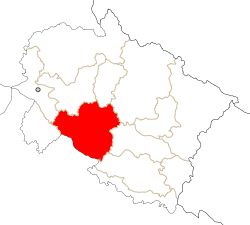 Location of Pauri Garhwal district in Uttarakhand | |
| Country | India |
| State | Uttarakhand |
| Administrative division | Garhwal |
| Headquarters | Pauri |
| Tehsils | 9 |
| Government | |
| • District collector | Sushil Kumar, IAS |
| • Assembly seats | Srinagar, Pauri, Yamkeshwar, Chaubattakhal, Lansdowne, Kotdwar |
| Area | |
| • Total | 5,329 km2 (2,058 sq mi) |
| Population (2011) | |
| • Total | 686,527 |
| • Density | 130/km2 (330/sq mi) |
| • Urban | 12.89% |
| Demographics | |
| • Literacy | 82.02% |
| • Sex ratio | 1103 |
| Vehicle registration | UK-12 |
| Major highways | National Highway 121, National Highway 119, National Highway 58 |
| Average annual precipitation | 1,545 millimetres (60.8 in) mm |
| Website | Official website |

District Pauri or Pauri Garhwal is situated in the state of Uttarakhand in Northern India with the town of Pauri as its headquarters. It lies between latitude 29.26 and 30.19 N and longitude 78.12 and 79.14 E. The maximum length from east to west is 103 km. and the maximum breadth from north to south about 100 km. Total geographical area of the district is 5,329 sq km.
The district is bounded by Dehradun and Haridwar on the west, district Bijnor (Uttar Pradesh) on the south, district Naini Tal and Almora on south-east, districts Chamoli and Rudraprayag on north east and north and on north-west is Tehri Garhwal. District Pauri is part of Garhwal Himalaya; Siwalik and Doons as per regional divisions scheme. The average height varies between 500 and 3000 meters from the mean sea level. The district is entirely mountainous. It consists of a succession of steep mountain ridges separated from each other by deep glens. The sub-mountain tract in the southern part of the district is known as bhabar (the belt of dry alluvial soil north of the tarai).
History
Human civilization in the Garhwal Himalayas has progressed with the rest of the Indian sub-continent. The Katyuri kings comprised the first historical dynasty, which ruled over unified Uttarakhand from 800 to 1100 and left records in the form of inscriptions and temples. After the downfall of the Katyuris, the Garhwal region was fragmented in more than sixty-four principalities ruled by chieftains. In the mid 15th century, Chandpurgarh emerged as a powerful principality under the rule of Jagatpal (1455 to 1493), who was a descendent of Kanakpal. At the end of 15th century, Ajaypal ruled Chandpurgarh and succeeded in unifying and consolidating various principalities on the region. His kingdom came to known as Garhwal. Subsequently, he transferred his capital from Chandpur to Devalgarh, before 1506, and later to Srinagar, from 1506 to 1519.[1]
King Ajaypal and his successors ruled Garhwal for nearly three hundred years. During this period they faced a number of attacks from Kumaon, Mughals, Sikhs, and Rohillas. An important event in the history of Garhwal was the Gorkha invasion, which was marked by extreme brutality. TThe word Gorkhyani has become synonymous with massacre and marauding armies. After subjugating Doti and Kumaon, the Gorkhas attacked Garhwal and reached as far as Langoorgarh, despite stiff resistance of the Garhwali forces. Then, news came of a Chinese invasion at the rear of the Gorkhas, who were forced to lift the siege. In 1803, the Gorkhas again mounted an invasion. After capturing Kumaon, they attached Garhwal. After initial defeats, King Pradyumna Shah escaped to Dehradun to futilely reorganize his defenses. Garhwali soldiers suffered heavy casualties and the king himself was killed in the battle of Khudbuda. The Gorkhas became the masters of Garhwal in 1804 and ruled the territory for twelve years.[1]
The Gorkha rule ended in 1815, when the British drove the Gorkhas west of the Kali River. On 21 April 1815, the British established their rule over the eastern half of the Garhwal region, lying east of the Alaknanda and Mandakini rivers, which became known as British Garhwal and Doon of Dehradoon. The remaining part of Garhwal, in the west, was restored to King Sudershan Shah, who established his capital at Tehri. Initially, the administration was entrusted to the commissioner of the Kumaon and Garhwal with his headquarters at Nainital; but later, in 1840, Garhwal was formed into a separate district under an assistant commissioner with his headquarters at Pauri.[1]
At the time of Indian independence, Garhwal, Almora, and Nainital districts were administered by the commissioner of Kumaon division. In early 1960, Chamoli district was curved out of Garhwal district. In 1969, Garhwal division was formed, with its headquarter at Pauri. In 1998, Rudraprayag district was formed, by carving out seventy-two villages of Khirsu block from Pauri Garwhal district, and Pauri district attained its present form.[1]
Geology[2]
On the basis of geology, soils, topography, climate and natural vegetation the district is divided in the following regions:
- Ganga Basin : The region extends towards the south of the Ganga river in the northern part of the district and is bounded by Alaknanda basin in the north-east and Lesser Himalaya and Siwalik in the south. It is mountainous region consisting of ridges, slopes, falls and valleys. The average height ranges between 450 and 2,000 meters from the mean sea level.
- Alaknanda Basin : The region extends along the south of the Alaknanda river in the northern part of the district and is bounded by Lesser Himalaya and Ganga Basin in the north. South of Alaknanda, a series of high hill ranges form a mountainous topography which consists of crest of the ridges with steep and gentle slopes, falls and valley bottoms. Most of the areas are covered with mixed jungles mainly of scrubs. The height ranges between 600 and 2,200 meters from the mean sea level. The slope of the region is towards north.
- Lesser Himalaya : This is the largest region which covers major central part of the district. It is bounded by Alaknanda, Ganga and Ramganga basins in the north, north-west and south-west respectively and Siwalik in the south-east. The region is a complete hilly zone, having peaks, valleys, slope areas, falls and crests etc. High peaks and deep valleys are visible at many places. The height varies from about 1,000 to 2,500 meters. North-eastern part of the region has the highest elevation (3,100 m) at Dudhatoli. Higher elevation areas are covered with dense mixed forests.
- Ramganga Basin : The region extends in the south-east of the district, bounded by Lesser Himalaya in the north and Siwalik in the west. This is the foot hill zone of Lesser Himalaya. Many of its characteristics are similar to that of the Siwalik. Southern part has comparatively low elevation while northern part is higher. The elevation varies between 500 and 1200 meters from the mean sea level. The region covers an area of 336.10 sq km
- Siwalik Hills : The region extends in the south-west of the district. It is bounded by Ganga Basin in the north and Lesser Himalaya in the north east. This is the moist belt of the Siwalik hills. Small and low elevated hillocks, saddles and their slope zone and valley bottoms form an undulating topography. The height varies from 400 to 1,200 m. from the mean sea level. South-west part from Kotdwara is plain and suitable for agriculture. Southern part of this region is low and flat but covered with natural vegetation.
Drainage
The chief rivers flowing through the district are the Ganga with its tributaries namely, the Alaknanda, the Nayaar (Nayaar East & Nayaar West), the Huinl, the Malin; and the Ramganga with its tributary the Mandal. There are hundreds of small streams which rise in the lower hills of Garhwal and join these rivers either in this district or in the district Bijnor of Uttar Pradesh.
Climate
A fairly long and moderately severe winter is the chief characteristic of the climate of the district. Being situated on the southern slopes of the Himalayas, it gets a good rainfall from the south-west monsoon current but tropical heat may be experienced from April to May and in the first half of June in the valleys. The temperature varies considerably from place to place depending on the elevation. Generally the end of May or the beginning of June is the hottest period. The mean daily temperature in the valleys (with elevation less than 1000 m.) is around 360C in the month of May and around 260C at about 2000 m. and still lower at higher altitudes. On individual days the maximum temperature may rise to over 400C in the valleys. With the onset of monsoon the day temperature start receding. With its withdrawal by the end of September, both day and night temperature start falling, reaching the lowest in January. During the winter months cold waves, associated with western disturbances may bring night temperatures down appreciably, even to below the freezing point of water on some occasions. The rainy season generally commences from the third week of June and lasts till the end of September. Rainfall in the district has large variations. July and August are the rainy months when nearly 55 per cent of the annual rainfall in the district occurs. Average rainfall is 1,545.1 mm. Winds are generally light and increase in velocity in the higher altitudes. In the wake of western disturbances and in association with thunderstorms, they may become quite strong.
Forestry
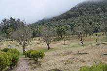
The forest area of the district comprises the whole of the Garhwal and Lansdowne forest divisions and the greater part of the Kalagarh forest division. Nearly 60 per cent area of the district is covered under forest. During the year 1998-99, 171,350 hectares reserve forest was under the control of forest department, 95,160 hectare treated as civil forest, 26,320 hectares forest was under control of panchayats and civic bodies and private owned forest was 620 hectares. Forest cover is dwindling rapidly due to indiscriminate felling, which is causing denudation of hill sides and consequent landslips. The extension of cultivation also led to loss of forests. The forest in the district extends from about 250 m. to over 3000 m above sea level and may be divided into three main altitudinal floristic divisions, the outer foothill forests, the warm temperate forests and the cool temperate forests.
- Outer Foothill Forests: These forests occur between the altitudes of 250 m to 1100 m, sal (Shorea robusta) being the dominant species along with its common associates, asna, haldu (Adina cordifolia) and dhauri. Other species found in these forests are khair (Acacia catechu), semal (Red silk cotton tree), dhak (Butea monosperma), sissoo (Dalbergia sissoo), jamun (Sizezium janabatend), kusum and bakli.
- Warm Temperate Forests: These are found between the altitudes of 1,000 m and 2,000 m, the dominant species of these forests is the chir (Himalayan pine tree, Pinus roxburghii). The vast chir expanses are broken up by pockets of oak. Burans and ayar are the two common associates of banj oak.
- Cool Temperate Forests: These are found between the altitudes of 2,650 m and 3350 m. The oak gives place to kharsu which occurs mixed with the high level pines such as silver fir and spruce.
In order to replenish and even to supplement the growing stock of valuable timber, species of industrially important plantations of khair, sissoo, haldu, semal, siris (Albtzia chinersis), toon (Cedrala toona) and mulberry have been raised in the bhabar and walnut, chestnut and chir in the hills. Forestry has a considerable influence on the economic development of the district. The district of Garhwal is very rich in respect of forest wealth especially in timber and herbs. The major forest produce is timber and wood for fuel. Other forest products include bamboo, oils, tanning materials, gums, resin, medicinal herbs, edible fruits, honey, wax and animal products like, hide, skin, bones etc. Scope of forestry is enormous in this district and Forest Department is taking care of this aspect for economic use and to maintain ecological balance. From time immemorial the district has been habitat of a large variety of animals, birds, reptiles and fish. Tiger is not uncommon in the bhabar and is found up to the height of about 3000 m. The panther which is also found is troublesome. The snow leopard occurs in upper Garhwal. The sloth bear and the black Himalayan bear is also found. The jackal is found almost everywhere. Among the deer tribe the sambur (Cernus unicolor) is the most widely distributed. The district is rich in avifauna. Commonly found birds are partridges, pigeons, doves and water-fowl of various kinds. Ducks occasionally rest on the rivers during their migration. Snakes are not numerous but most of the species occurring in the plains are found in the district. Fish are found in almost all the rivers and streams of the district and in most part constitute the common food of the people.
Minerals and mining
High grade limestone (used in the manufacture of cement, lime, sugar and paper) occurs in the district and is mined extensively. Pockets of gypsum are found which is used mainly for the making of plaster of Paris. Silver, zinc and lead is available in the south side of Dudhatoli mountains. Sulphide mineral is available up to the height of 1500 m. In the absence of necessary survey no advantage have been earned so far from the available minerals.
Soil
Being in the Himalayan region, the district of Garhwal contains little level ground. The slope of the hills is usually too steep for cultivation without terracing. Finer soils are to be found only in the river valleys where they widen out. Those portion of the district which are covered with snow for the greater part of the year, have no distinct agronomic value. Agriculture in the hills depends on the composition of the soil, the position of field (the height above sea level and its aspect), the presence or absence of irrigation (besides rainfall), temperature and snow fall. The position of the fields in relation to sunshine and the availability of irrigation facilities also determines the success or otherwise of agricultural operations. Usually cultivation can be done up to an altitude of about 1981 m. Plain part of the district has fertile land. Although the soil of the hill area is fertile but mostly soil is stony. In plain region domat, loam and clay soils are found. Red, grey, brown and dark-brown soils are also found in different parts of the district.
Agriculture and Crop pattern[3]
Agriculture is the main occupation of the people of the district. From a study of the occupational structure of the economy of the district, it is obvious that about 66 per cent of the working force was engaged in agriculture and allied activities at the 1991 census. Level land being scarce, cultivation is generally done on terraced fields. Continuous plough over a number of years, hard and sustained labour and large investments are needed to construct and maintain the terraces. Generally the land is cultivated regularly but the period of fallow allowed between the harvests is so long that the land becomes very fertile. In the greater part of the district there are two harvests, kharif and rabi, but in the cooler climate of the hills, the crops require a longer period to ripen. The kharif is reaped in September and the rabi crops are generally sown in October – November and harvested from the end of April to the middle of May or even later in the fields that are situated higher up.
From the agro-climatic point of view, the district can be divided into three parts, places with a height up to 1,219 m including river valleys and the bhabar; places with an altitude from 1,219 m to 1,828 m and high mountains above 1828 m The height of the river-valley areas ranges from 304 m to 1,219 m above sea level and climatically they are neither very hot nor very cold and receive adequate rain. The soil being fertile having adequate irrigation facilities, it enables both the rabi and kharif to give better yields. The main crops are wheat, mustard and barley in the rabi and paddy, maize, ‘Koda’ and ‘Jhangora’ (coarse millets) in the kharif. Other crops grown are pepper, ginger, turmeric and sugar-cane. Garhwal is famous for its turmeric, ginger, chillies, onion and spinach. The necessity of augmenting agricultural production was realized and as a remedial measure the government launched a ‘grow more food’ campaign providing several incentives to increase farm output. Improved and scientific methods of growing crops have been popularized among the cultivators of the district. Government give financial assistance to the cultivators to buy seeds, implements and fertilizers for better agricultural production.
To facilitate the farmers in their pursuit for higher agriculture production, they are provided the services of 15 seed godowns/fertilizer depots and 15 insecticide depots. For storage of grains state government and co-operative sector have provided 42 and 46 warehousing go downs respectively. There is one godown of Central Warehousing Corporation and 2 godowns of other agencies. Total arable land under wheat cultivation was 42 per cent, distantly followed by 15 per cent for paddy and 13 per cent for sawa during 1997-98. During the same period yield per hectare for wheat was 11.85 quintal, paddy 10.74 quintals and maize 10.65 quintal. The three main enemies of crops are animals, birds and insects. There are many leafy growths and weeds which are also harmful to the crops. The plant protection department, with its trained personnel posted in the district, provides free advice to the cultivators about raising healthy crops of fruits, vegetables and cereals and taking up timely measures for protection of plants from diseases and pests. Most of the cultivable land is situated in the steep hill sides and so is very susceptible to the ravages of soil erosion. In many areas, the top soil is completely washed away by the rains. Various methods of soil conservation has been adopted in the district to tackle this problem.
Irrigation
To a large extent cultivation in the hills also depends on the availability of irrigation facilities. In the district, rainfall is the main source of irrigation. Though abundant, the rains do not satisfy irrigational requirements of the district. Due to the mountainous nature of the terrain, big irrigation projects do not have much scope and so the stress is on the construction of minor irrigation projects, particularly small water channels. The Ramganga River Project at Kalagarh in the district is one of the biggest engineering feat of the state to tame a turbulent stream for economic prosperity. For irrigation purposes, the district has 772 km long canal network, 16 government tube wells, 5179 hauz (reservoir), 1398 km long gul and 131 high drums. Out of the total irrigated land 49 per cent is irrigated by canals, 7 per cent by government tube wells and rest of 44 per cent is irrigated by other sources.
Animal Husbandry
Livestock plays a vital role in the economic life of the people of the district. The hill cattle generally differ from those of the plains in build, being shorter but they are more active. The cows; buffaloes and goats are the main sources of milk. Oxen and male buffaloes are used for plough the fields. Sheep and goats are reared chiefly for their meat and milk. The development of cattle is difficult on account of the inadequacy of grazing grounds and cultivable land for growing fodder for them. According to the live-stock census of 1993 the district had 365,902 bovine population, 77,648 buffaloes, 42370 sheep, 168882 goats, 669 pigs and 17,051 other animals. To improve the breed of the cattle, the district had 11 artificial insemination centres and 5 sub-centres. For the development of animals there were 68 animal development centres and 39 veterinary clinics during 1998-99 in the district. During the same period, the district also had 8 sheep development centres. Trading in wool and woolen goods has been one of the main occupations of the people of these hills from time immemorial. Not only is wool obtained from sheep but their skin and meat are also commercially useful.
Fisheries
The chief species of fish found in the rivers of the district are mahseer (Barbus species), rohu (Labeo Rosita), kali machi, asola, baiyan, dhaur and gadera. For promotion of fisheries as an alternative occupation, fisheries department is functioning in the district. There were 4 departmental ponds during 1998-99. The department had distributed 55 thousand fingerlings during the same period. Pisciculture has not yet developed into an economically viable occupation in the district.
Industry[4]
The area covered by the district of Garhwal is predominantly agricultural. Some cottage industries have been in existence in this area for long, the chief being the woolen industry. The manufacture of mats and baskets from ringal (Himalayan bamboo, growing at altitudes between 1000 and 2000m, Arundinaria falcata) is also an old industry. Galvanized iron pipes, wire-netting, bolts, buckets, cutlery etc. are produced in the rural areas. Besides these, there are few units of carpentry goods, engineering goods, soap and candles, leather and plastic goods and brassware and copperware are also located in the district. Till 1998-99 the district had one industrial area with 8 sheds and 26 plots, out of which 13 were functioning. Only large scale industry of this district is Bharat Electronics Ltd., Balbhadrapur, Kotdwar which manufactures Switching, communication equipment. Among medium scale industries, a flush door factory manufacturing flush door and ply board and Indica Chemical Pvt. Ltd. at Balbhadrapur, Kotdwar are important industrial units. Besides these, there are 3570 small scale industries in the district.
Trade and Commerce
The district had trade relations with Tibet from very early times. The trade with Tibet came to a standstill in 1962. With the development of roads in the district the quantity of imports and exports has increased from other parts of the country. The importance of Kotdwar has increased and it occupies as the most prominent commercial centre of the district. The pattern of trade has not changed to any considerable extent over the decades. The main exports of the district are timber, resin, herbs, apples and potatoes. The imports comprise food grains, pulses, sugar, salt, kerosene oil, cloth, medicines and utensils. The important trade centres in the district are Kotdwar, Lansdowne, Dogadda, Pauri and Srinagar. The requirements of the people residing in the villages of the district are generally supplied by small local bazaars. Small markets are scattered all over the district.
Transport[5]
The most common mode of transport is by either bus or taxi. Bus services are provided by the state-run Uttarakhand Roadways, Garhwal Motor Owner Union (GMOU) Ltd., and Garhwal Motor Users (GMU) Ltd. Operations of Uttarakhand Roadways are limited mainly to interstate routes and major cities and towns of the district and state. GMOU Ltd. is the largest bus service provider in the district, providing services to almost all parts of the district. The services of GMU Ltd. are limited to a comparatively small area adjoining Kumaon division. There are a number of taxi unions in many towns of the district, providing service for almost every local stretch of road. The only railway station in the district is at Kotdwara. It was established by the British as early as 1889. Pauri Garhwal district is situated in the Shiwalik range, the outermost range of the Himalayas, and its hills are very rugged. As a result, it is not considered feasible to extend the railway network further. The district does not have any regular air services. The nearest is Jolly Grant Airport, near the state capital of Dehradun, about 155 kilometres (96 mi) from Pauri and 120 kilometres (75 mi) from Kotdwara.
The land routes in the district are mainly of three types; those connecting the district with the plains, those which connect it with its neighbouring districts of the hills and those that are purely local. The first are most important from the economic point of view. The centre and west of the district have their outlet at Kotdwar railway station. Kotdwar is the only railway station of the district Garhwal. The means of transport in the district are state and private buses, jeep and trucks etc. During 1998-99 the district had 427 bus stations. During 1997-98 the district had 2,845 km. long metalled road under different administrative units. There is no national highway in the district and length of state highways passing through the district was 323 km. during 1997-98.
Demographics
As of 2001 Indian census, the Pauri Garhwal district had a population of 697,078, with a religious breakdown of 673,471 Hindus, 20,157 Muslims (2.89%), and 1,915 Christians.
According to the 2011 census, Pauri Garhwal district has a population of 686,527,[6] which is almost equal to the 2014 population of Equatorial Guinea,[7] and to the US state of North Dakota.[8] This gives it a ranking of 506th in India (out of a total of 640). The district has a population density of 129 inhabitants per square kilometre (330/sq mi). Its population growth rate over the decade of 2001-2011 was -1.51%. Pauri Garhwal has a sex ratio of 1103 females for every 1000 males, and a literacy rate of 82.02%.[6]
Administrative structure
In 1960, what was known as Garhwal district was divided into Pauri Garhwal and Chamoli districts. In 1997, an additional area was carved out of Pauri Garhwal district and merged with parts of Chamoli and Tehri Garhwal districts to form Rudraprayag district.
The District is administratively divided into nine tehsils and fifteen developmental blocks.
Tehsils
Development blocks
- Kot
- Kaljikhal (largest block in Pauri Garhwal)
- Pauri
- Pabau
- Bironkhal
- Dwarikhal
- Dugadda
- Jaihrikhal
- Ekeshwer
- Rikhnikhal
- Yamkeswar
- Nainidanda
- Pokhra
- Khirsu
Education
Pauri, Kotdwar, Lansdowne and Srinagar are major centres of education in the district. Govind Ballabh Pant Engineering College is at Ghurdauri (11.5 kilometres (7.1 mi) from Pauri). Hemwati Nandan Bahuguna Garhwal University, Veer Chandra Singh Garhwali Government Medical College, and National Institute of Technology Uttarakhand are in Srinagar.
Tourism
Tourism in Pauri Garhwal District includes a number of exploring options. Pauri Garhwal attracts people through its environment, valleys, and mountain peaks, and natural features. Tourists in Pauri also visit its ancient temples.
Khirsu
The mountains of Khirsu offer views of the northern Himalayas and attract a large number of tourists. Located 19 kilometres (12 mi) away from Pauri at an altitude of 1,700 metres (5,600 ft), Khirsu is peaceful and free from pollution. There is the nearby ancient temple of Ghandiyal Devta. Accommodation is available at the Tourist Rest House, Forest Rest House, and private hotel.
On the 4th Monday of April or 1st Monday of May, there is an annual Mela put on by local villagers.
The villages of Gwarh and Khothgee, near Khirshu, have a festival where they lower an artificial carved wooden effigy of man, called "Badi" by locals, by rope down a hill for about 500 meters.
Chaukhamba View Point
Situated only 4 km from Pauri. Chaukhamba View Point overlooks the Idwal Valley, with views of the Chaukhamba peaks. It is known for its scenic vistas.
Religious shrines
Kandoliya Devta
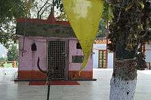
The main temples of the city are Kandoliya Devta, Laxmi Narayan, Kyunkaleshwar Mahadev, and Hanuman Mandir. Every year, a bhandara is organized on the premises of the temple of Kandoliya Devta, and thousands of people from Pauri and nearby villages participate in it. The city has a number of picnic spots surrounded by deodar forests, viz. Ransi, Kandoliya, Nag Dev, Jhandi Dhar, etc. Every year since 1974, Sharadotsav is celebrated in the city.
Danda Nagraja Temple
The holy shrine of Danda Nagraja is a popular pilgrimage among the Garhwali people. Garhwalis from around the country visit the shrine every day. It is located in the Lasera village, patti Banelsyun, Pauri district (lap of mountains). The temple gets its name from the Garhwali word Danda, which means "peak". Since the temple is in a forest, local people started calling it Danda Nagraja - "Nagraja on the Peak".
Legend has it that when Lord Krishna came here for the first time, he came in the form of a snake and crawled all the way up the ridge to reach the spot where the temple now stands. Locals have a strong belief that Lord Krishna still stays here and has done so over many centuries. They say they receive the special blessings of Danda Nagraja. Popular faith is that Danda Nagraja has the power to foresee any ill coming to the area and always informs them about any mishap that is about to occur. Not just that, locals say the Lord also gives them the solution to the problem. The temple’s high priest tells you with conviction that if any devotee prays sincerely, Danda Nagraja always fulfills his wishes. In part because of this temple, Pauri Garhwal is known as a "Land of Miracles".
A feature of this temple is the thousands of bells that have been hung in the temple premises by devotees after their wishes were fulfilled. There is also a custom of devotees offering jaggery (gurh) as prasad (offering) to the reigning deity. After a darshan (vision) of श्री डांडानागराजा (Shri Danda Nagraja), the pilgrims take a parikrama (ritual walkabout) of the temple to get the blessings of the God.
"The temple not only attracts local people but, every year, many foreigners come visiting and they donate bells with their names written all over. The main visitors are from the US and UK," the priest tells you.
Danda Nagraja is approximately 90 kilometres (56 mi) from Kotdwara, 45 kilometres (28 mi) from Satpuli, and 35 kilometres (22 mi) from Pauri. The temple is situated at the top of a hill with ample space around the structure for pilgrims to relax. It can be reached by taking a bus either from Kotdwara or Pauri. However, bus service is limited, with usually no more than two buses on a route. So, the better option is to hire a taxi.
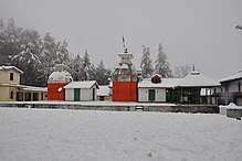
Jwalpa Devi Temple
This is a famous Shakti Peetha of Garhwal dedicated to the Goddess Jwalpa. It is situated on the right bank of the Nawalika River (nayar), 34 kilometres (21 mi) from Pauri, on the main Pauri-Kotdwara road. According to a legend in the Skanda Purana, Sachi (daughter of the demon king Pulom) wanted to marry devraj Indra, so she worshipped the supreme mother Goddess Shakti here. The Goddess then appeared in the form of Deeptimaan Jwalehwari and her wish was fulfilled. Deeptimaan Jwalehwari was eventually shortened\ to Jwalpa Devi. It is said that Adi Guru Shankaracharya visited and prayed in this temple, and that the Goddess appeared to him. Every year two Navratri fairs are held: Chitra and Shardiya Navratri. The Anthwal family are the traditional priests and caretakers of this temple, as the present temple was constructed by the late Pandit Shri Dutta Ram Anthwal (the Anthwals, originally from village Aneth, being the zameendaar, or landlords, of the area). Every year thousands of people visit this temple, especially unmarried girls, as it is said that the girls get fine grooms just like Indrani (Shachi) got Lord Indra by the grace of The Goddess.
Shoonya Shikhar Ashram
This is a spiritual center near Kotdwara. One can reach it by 7 km of trekking from village Balli, which is itself around 30 km uphill from Kotdwara. Shoonya Shikar Ashram is known for the meditation cave of Sadguru Sadafaldeo Ji Maharaj.[9] This is the place where Swarved was written.[10] It attracts people from all over the world, in particular the followers of Vihangam Yoga, who seek high-level meditation.
Kyunkaleshwar Mahadev
Situated in the suburbs of Pauri, with views of the snow-laden Himalayas, Kyunkaleshwar Mahadev is an 8th-century temple dedicated to Lord Shiva, the presiding deity, who is accompanied by Goddess Parvati, Ganesha, and Kartikeya.
Tarkeshwar Mahadev
36 km from Lansdowne, at a height of 1,800 m, this place is known for its temple dedicated to Lord Shiva. It is surrounded by forests of deodar and pine. During Shivratri, and in the month of May, special worships are held. The temple committee provides a dharamshala for accommodations.
Tarkeshwar Dham is 5 km from Chakhuliyakhal and 20 km from Rikhnikhal.
Ekeshwar Mahadev
26 km from Satpuli, at a height of 1,820 m, this place is a sidhpeeth dedicated to Lord Shiva, with views and a calm climate. During Shivratri, a special worship is held. The road from Satpuli to Ekeshwar offers views of the snow-covered Chaukhmba peaks.
Binsar Mahadev
Amidst dense forests of birch, rhododendron, and deodar, is the temple of Binsar Mahadev, at an altitude of 2480 m and a distance of 114 km from Pauri. The sanctuary of the temple houses the deities Hargauri, Ganesh and Mahisasurmardini. The temple is believed to have been constructed by Maharaja Prithu in memory of his father Bindu, so is also known as Bindeshwar Temple. A big fair takes place here on the occasion of Baikunth Chaturdashi, every year. The nearest town is Thalisain, about 25 km by road and about 4–5 km by trekking overland.
Doodhatoli
Doodhatoli, at an altitude of 3100 m, is covered with dense mixed forest. Thalisain, 104 km. from Pauri, is the last bus stop, from where Doodhatoli is 24 km distant by trek. It picturesque and offers a panoramic view of the Himalayas.
Tarakund
Situated at a height of 2200 m, Tarakund is a small picturesque spot amidst lofty mountains in the Chariserh Development Area. A small lake and an ancient temple adorn the place. The Teej festival is celebrated with great gaiety when the local people come here to worship and pay homage to God. On the occasion of Shivratri, local people go Tara Kund to worship Lord Shiva.
The distance from the main road to Tarakund is about 8 km. Palli is the nearest village.
Kanvashram
Kanvashram is an important destination from an historical and archaeological point of view.
According to legend, this is the place where the great sage Swami Vishvamitra meditated and Indra, fearing Vishwamitra’s intense meditation, sent a charming heavenly damsel Menaka to distract him. Menaka succeeded in seducing, and thus distracting, the sage. A daughter named Shakuntala was born as the fruit of their union. She was then left in the ashram, in the care of Rishi Kanva. Shakuntala later, upon marriage with Dushyant, the ruler of Hastinapur, gave birth to prince Bharat. It is by virtue of this name - Bharat - that India came to be called Bharatvarsha and thus Bharat.
Kanvashram has much to offer visitors. Those seeking solitude can relax amidst forested surroundings of Kanvashram, while a number of long and short trekking routes are there to satisfy the adventurous. For a long hike, one can reach Sahastradhara Falls after a one-hour trek.
There is also a Gurukul that one can visit. This Gurukul – a traditional school for boys – provides services like massages and conducts courses in yoga, besides making available a host of ayurvedic medicines.
Comfortable boarding and lodging facilities are available in Kanvashram. One can stay at the Gurukul, or one can spend the night at the GMVN tourist rest house.
Kanvashram is well-connected by road with the region. The nearest railhead is at Kotdwara which is 14 km away while the nearest airport is Jolly Grant at Dehradun.
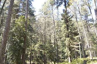
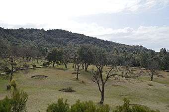
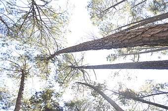
Image Gallery of the Places around Pauri Garhwal
References
- 1 2 3 4 "History". Government of Uttarakhand: Pauri Garhwal. Retrieved 16 September 2018.
- ↑ http://censusindia.gov.in/2011census/dchb/0506_PART_B_DCHB_GARHWAL.pdf
- ↑ http://shodhganga.inflibnet.ac.in/bitstream/10603/14978/10/10_chapter%204.pdf
- ↑ http://dcmsme.gov.in/dips/DIPSR%20-%20PAURI.pdf
- ↑ http://icrier.org/pdf/Working_Paper_217.pdf
- 1 2 "Pauri Garhwal District : Census 2011 data". Census2011.co.in. 2011. Retrieved 29 November 2015.
- ↑ US Directorate of Intelligence. "Country Comparison:Population". Retrieved 2011-10-01.
Equatorial Guinea 668,225 July 2011 est.
- ↑ "2010 Resident Population Data". U. S. Census Bureau. Archived from the original on 1 January 2011. Retrieved 2011-09-30.
North Dakota 672,591
- ↑ "Shoonya Shikhar Ashram". Vihangam Yoga. 2010. Retrieved 30 November 2015.
- ↑ "Swarved". Vihangam Yoga. 2010. Retrieved 30 November 2015.
External links
| Wikimedia Commons has media related to Pauri Garhwal district. |
Places adjacent to Pauri Garhwal district | |
|---|---|