Parkside Avenue (BMT Brighton Line)
Parkside Avenue | |||||||
|---|---|---|---|---|---|---|---|
|
| |||||||
 | |||||||
| Station statistics | |||||||
| Address |
Parkside Avenue & Ocean Avenue Brooklyn, NY 11225 | ||||||
| Borough | Brooklyn | ||||||
| Locale | Prospect Lefferts Gardens | ||||||
| Coordinates | 40°39′19″N 73°57′42″W / 40.65535°N 73.961651°WCoordinates: 40°39′19″N 73°57′42″W / 40.65535°N 73.961651°W | ||||||
| Division | B (BMT) | ||||||
| Line | BMT Brighton Line | ||||||
| Services |
Q | ||||||
| Transit connections |
| ||||||
| Structure | Open-cut | ||||||
| Platforms | 2 side platforms | ||||||
| Tracks | 4 | ||||||
| Other information | |||||||
| Opened | before 1895 | ||||||
| Rebuilt | current station: 1919 | ||||||
| Station code | 043[1] | ||||||
| Former/other names | Woodruff Avenue | ||||||
| Traffic | |||||||
| Passengers (2017) |
1,953,704[2] | ||||||
| Rank | 249 out of 425 | ||||||
| Station succession | |||||||
| Next north |
Prospect Park: Q | ||||||
| Next south |
Church Avenue: Q | ||||||
| |||||||
| |||||||
| |||||||


Parkside Avenue is a local station on the BMT Brighton Line of the New York City Subway. Located at Parkside Avenue and Ocean Avenue in Flatbush, Brooklyn, it is served by the Q train at all times.[3]
History
This station was originally built sometime before 1895 by the Brooklyn and Brighton Beach Railroad as Flatbush station. Through a series of mergers and acquisitions, it was acquired by the Brooklyn Rapid Transit Company, and reopened in 1907 as a two-track station named Woodruff Avenue.
This portion of the line was rebuilt from a two-track open cut to a four-track open cut in 1919.
After August 1, 1920, through service was shifted from the current BMT Franklin Avenue Line to a new subway alignment under Flatbush Avenue, which permitted direct access to Manhattan via the Manhattan Bridge and the Montague Street Tunnel.[4]
During the 1964–1965 fiscal year, the platforms at Parkside Avenue, along with those at six other stations on the Brighton Line, were lengthened to 615 feet to accommodate a ten-car train of 60-foot IND cars, or a nine-car train of 67-foot BMT cars.[5]
Station layout
| G | Street level | Station building, entrance/exit, station agent, MetroCard vending machines |
| P Platform level |
Side platform, doors will open on the right | |
| Northbound local | ← | |
| Northbound express | ← | |
| Southbound express | | |
| Southbound local | | |
| Side platform, doors will open on the right | ||
This station currently has four tracks and two side platforms. The two center express tracks are used by the B train when it operates on weekdays.[6]
The original southern two-thirds of the platforms are in a tunnel underneath cross streets and buildings, while the remaining northern one third is in an open cut. The extreme north ends of the platforms, which were extensions built in the 1960s, have no canopies and curve to the north. The southbound platform has its concrete wall painted beige while the northbound one is carved within the Earth's crust. Here, the station signs are the standard black plates in white lettering. The rest of the open cut has a concrete canopy with red columns. The remainder of the platforms in the tunnel has red columns and a red trim line and mosaic name tablets reading "PARKSIDE AVE." in gold Times New Roman font surrounded by diamonds.
The 1994 artwork here is called Brighton Clay Re-Leaf by Susan Tunick. It features ceramic tiles portraying leaves in the station house within fare control. This artwork can also be found at the Prospect Park station.
Exits
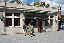
The station's main entrance/exit is a street level station house on the northern end of the tunnel above the platforms and tracks. Two staircases from each platform go up to a waiting area/crossover, where a turnstile bank provides entrance/exit from the system. Outside fare control, there is a token booth and two sets of doors, one leading to Parkside Avenue and Ocean Avenue and the other to the southern entrance of Prospect Park.[7]
The Coney Island-bound platform has an exit-only at the extreme south end. A single platform-level turnstile leads to a short tunnel, where a staircase goes up to the southwest corner of Woodruff and Ocean Avenues. The extreme south end of the Manhattan-bound platform has an employee-only facility.[7]
References
- ↑ "Station Developers' Information". Metropolitan Transportation Authority. Retrieved June 13, 2017.
- ↑ "Facts and Figures: Annual Subway Ridership 2012–2017". Metropolitan Transportation Authority. July 12, 2018. Retrieved July 12, 2018.
- ↑ "Q Subway Timetable, Effective June 24, 2018" (PDF). Metropolitan Transportation Authority. Retrieved June 24, 2018.
- ↑ "New Subways Add Seven More Miles to BRT on Aug 1". Brooklyn Daily Eagle. July 25, 1920. Retrieved August 19, 2016 – via newspapers.com.
- ↑ Annual Report 1964–1965. New York City Transit Authority. 1965.
- ↑ Dougherty, Peter (2006) [2002]. Tracks of the New York City Subway 2006 (3rd ed.). Dougherty. OCLC 49777633 – via Google Books.
- 1 2 "MTA Neighborhood Maps: Crown Heights" (PDF). mta.info. Metropolitan Transportation Authority. 2015. Retrieved January 1, 2017.
External links
| Wikimedia Commons has media related to Parkside Avenue (BMT Brighton Line). |
- nycsubway.org – BMT Brighton Line: Parkside Avenue
- Station Reporter — Q Train
- The Subway Nut — Parkside Avenue Pictures
- MTA's Arts For Transit — Parkside Avenue (BMT Brighton Line)
- Parkside Avenue entrance from Google Maps Street View
- Ocean Avenue exit only stair from Google Maps Street View
- Tunnel part from Google Maps Street View
- Open-cut part from Google Maps Street View
Broadway Express/ Brighton Local |
|
|---|---|
| |
| Brighton Line |
|
|---|---|
| |