New Zealand State Highway 6
| ||||
|---|---|---|---|---|
 | ||||
| Route information | ||||
| Maintained by NZ Transport Agency | ||||
| Length | 1,162 km (722 mi) | |||
| Tourist routes |
Southern Scenic Route | |||
| Major junctions | ||||
| North end |
| |||
| South end |
| |||
| Location | ||||
| Primary destinations | Nelson, Murchison, Inangahua Junction, Runanga, Greymouth, Hokitika, Haast, Wanaka, Cromwell, Queenstown, Lumsden, Winton | |||
| Highway system | ||||
| ||||

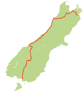
State Highway 6 is a major New Zealand state highway. It extends from the northeastern corner of the South Island across the top of the island, then down the length of the island, initially along the West Coast and then across the Southern Alps through inland Otago and finally across the Southland Plains to the island's south coast. Distances are measured from north to south.
The highway is the longest single highway in the country, though it is shorter than the combined totals of the two highways that comprise State Highway 1, SHs 1N and 1S.
For most of its length SH6 is a two-lane single carriageway, except for 5.4 km of dual carriageway in Invercargill, and passing lanes in Invercargill and Nelson, with at-grade intersections and property accesses, both in rural and urban areas. Roundabouts are common in major towns, with traffic signals only found in Invercargill, Queenstown, Richmond, and Nelson, with signals also controlling the Kawarau Bridge in Queenstown and Fern Arch near Westport. NZTA classified the highway as an arterial route, except for two sections between Blenheim (SH 1) and Richmond (SH 60) and between Cromwell (SH 8B) and Five Rivers (SH 97) where SH 6 is classified as a regional strategic route.[1]
Route
Nelson/Marlborough
The highway leaves SH1 at Blenheim, initially heading northeastward across the rugged hills at the base of the Marlborough Sounds. it reaches the sounds briefly at Havelock, then heads inland up the valley of the Pelorus River. At Pelorus Bridge the highway again turns north, then tends southwest as it approaches the coast of Tasman Bay. The highway travels through the city of Nelson and nearby town of Richmond, continuing southwest across the plains of the Wairoa and Motueka Rivers.
From these plains, the road ascends rapidly to the 634-metre Hope Saddle. From here, the highway heads generally westward, along the valley of the Buller River and its tributaries. Beyond Murchison, this valley narrows to become the scenic Buller Gorge, and the highway twists its way high above the waters of the river.
West Coast

The highway leaves the river as its valley broadens, turning south six kilometres from Westport, where the river reaches the sea. From here, the highway keeps close to the Tasman coast from Charleston for over 100 kilometres, turning inland only briefly near Runanga. This 100-kilometre stretch includes two of the coast's larger towns, Greymouth and Hokitika.
From Hokitika, the highway moves away from the coast, though still generally keeps within five kilometres of the sea. The highway continues south past Ross and Harihari, moving through state forests as it crosses several fast-moving rivers. Seventy kilometres south of Harihari, the highway skirts Lake Mapourika and reaches the tourist settlement of Franz Josef Glacier. The glacier itself, one of two within easy walking distance of the highway, lies nearby in the Southern Alps, which here come very close to the Tasman coast. The second glacier, Fox Glacier is located some 20 kilometres further south. The highway again briefly touches the coast at Bruce Bay before heading inland past Lake Paringa, before reemerging on the Tasman coast at Knights Point. The 30 km stretch of highway from here south to Haast is noted for its rugged scenery. After crossing the Haast River, the highway turns eastward and inland up the river's valley, climbing past the Gates of Haast and crossing the 563-metre Haast Pass, the southernmost of the three main road passes across the Southern Alps.
Otago
From here, the highway again turns south, following the Makarora River valley to the northern tip of Lake Wanaka. The highway skirts the eastern coast of the lake before crossing The Neck, a saddle in the mountains that lie between Lakes Wanaka and Hāwea. The highway continues along the western shore of Hāwea, then south along the Cardrona River to Albert Town, close to the tourist centre of Wanaka.


Ten kilometres from Wanaka, the highway is met by SH 8A, a spur of SH 8 skirting the shore of Lake Dunstan. SH 6 continues south along the western shore of the Lake, paralleling SH 8 which lies on the eastern shore. Close to Cromwell, a second spur, SH 8B, connects the two highways. From here, SH6 turns west, following the narrow and twisting Kawarau Gorge, emerging close to the wine-producing area of Gibbston.
At the western end of the Kawarau Gorge, midway between Cromwell and Queenstown, the highway passes the Nevis Bluff, a steep schist rock outcrop rising 100 m above the Kawarau River. The highway has a history of being disrupted and closed at this point due to instability and rock falls from the bluff. The first road around the bluff was constructed in 1866, opening access to the Wakatipu goldfields.[2] Significant slips occurred at the bluff on 1940-02-20,[3] and blocking SH6 in June 1975.[4] On 17 September 2000, a large-scale rock fall buried the highway at the bluff, and several motorists narrowly avoided being killed. The fall was caught on video and showed a volume of 10,000 m³ for the main fall; the resulting dust cloud was seen 5 km away.[5][6] Transit New Zealand conducted stabilisation drilling and blasting at the bluff twice in 2006 and again in 2007.[7]
From the Nevis Bluff, the highway continues west, reaching Frankton, close to the shore of Lake Wakatipu. The highway turns south to follow the southeastern shore of the lake, skirting the foot of The Remarkables and the Hector Mountains. This stretch of the highway is in part tortuously winding, and rises and falls over a stretch known as "The Devil's Staircase".
Southland
The highway leaves the lake's shore at Kingston, continuing south to Garston, where, the highway briefly follows the course of the infant Mataura River before heading across rolling hill country to the upper reaches of the Oreti River near Lowther. The highway continues to follow the Oreti south across the Southland Plains, past the towns of Lumsden and Winton before reaching its terminus at a junction with SH 1 in central Invercargill.
State Highway 6 spurs
SH6 has one spur, designated ![]()
![]()
Engineering features
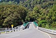
- Hawk's Crag is a single-lane half tunnel blasted out of a solid rock bluff in the Buller Gorge. It was constructed in 1869.[8]
- The highway featured a number of combined road-rail bridges, but several have now been replaced.
- The Haast River bridge (km 750.0) is now the longest single-lane bridge in the country, with two passing bays.[9]
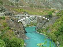
- A two-lane bridge was built at Kawarau Falls just south of Frankton. This superseded the one-lane bridge that was up until then the highway crossing.[10] This opened in 2017.[11]
Route changes
SH 6 in Nelson City previously went through Stoke between Annesbrook Drive and the Richmond Deviation via Main Road. In 2003, SH 6 shifted to the newly constructed Whakatu Drive, bypassing much of the residential areas.[12]
Major junctions
| Territorial authority | Location | km | jct | Destinations | Notes |
|---|---|---|---|---|---|
| Malborough District | Blenheim | 0 | SH 6 begins | ||
| Renwick | 10 | ||||
| 14 | |||||
| 15 | Wairau River | ||||
| Pelorus Bridge | 59 | Pelorus River | |||
| Nelson City | District contains no major junctions | ||||
| Tasman District | Richmond | 129 | |||
| Kohatu | 169 | Motueka Valley Highway – Tapawera, Motueka | Former SH 61 | ||
| 196 | Hope Saddle (634 m) | ||||
| Kawatiri | 209 | ||||
| Longford | 238 | Longford Bridge (Buller River) | |||
| Ariki | 255 | ||||
| O'Sullivan's Bridge (Buller River) | |||||
| Buller District | Lyell | 282 | Iron Bridge (Buller River) | ||
| Inangahua Junction | 297 | ||||
| Westport | 328 | ||||
| Grey District | Greymouth | 430 | |||
| Camerons | 445 | Taramakau River Bridge Hokitika Line | Combined road-rail bridge | ||
| Westland District | |||||
| Kumara Junction | 448 | Hokitika Line | Rail line bisects roundabout | ||
| Harihari | 541 | Wanganui River | |||
| Franz Josef | 610 | Waiho River | |||
| Fox Glacier | 634 | Fox River | |||
| 639 | Cook River | ||||
| Karangarua | 659 | Karangarua River | |||
| Paringa | 695 | Paringa River | |||
| Haast | 750 | Haast River Bridge | |||
| Mt Aspiring National Park | 815 | Haast Pass (564 m) | |||
| Queenstown-Lakes District | |||||
| Albert Town | 891 | Clutha River | |||
| Mt Iron | 893 | ||||
| Luggate | 901 | via Lindis Pass | |||
| Central Otago District | Cromwell | 942 | |||
| Queenstown-Lakes District | Arrow Junction | 983 | Crown Range Road – Cardrona, Wanaka | Former SH 89 | |
| Frankton | 996 | SH 6/Southern Scenic Route concurrency begins | |||
| 997 | Kawarau Falls Bridge (Kawarau River) | Bridge was replaced in 2017 | |||
| Southland District | Athol | 1061 | Black Bridge (Mataura River) | ||
| Five Rivers | 1082 | SH 6/Southern Scenic Route concurrency ends | |||
| Lumsden | 1093 | SH 6/SH 94 concurrency begins | |||
| 1095 | SH 6/SH 94 concurrency ends | ||||
| Winton | 1143 | SH 6/SH 96 concurrency begins | |||
| 1145 | SH 6/SH 96 concurrency ends | ||||
| Invercargill City | Lorneville | 1168 | SH 6/Southern Scenic Route concurrency begins | ||
| Invercargill | 1176 | SH 6 ends | |||
See also
| Wikimedia Commons has media related to State Highway 6 (New Zealand). |
- List of New Zealand state highways
- List of roads and highways, for notable or famous roads worldwide
- Nelson - Blenheim notional railway; between 1957 and 1979,for the purpose of subsidising passenger and freight rates, the Nelson - Blenheim section of SH6 was deemed by law to be a railway.
References
- ↑ "One Network Road Classification: South Island State Highways" (PDF). New Zealand Transport Agency. Retrieved 6 March 2016.
- ↑ "Otago Goldfields Heritage Trail - Queenstown". New Zealand South. Archived from the original on 8 February 2012. Retrieved 8 May 2008.
- ↑ "Transactions and Proceedings of the Royal Society of New Zealand 1868-1961". Retrieved 2008-05-08.
- ↑ Brown, Ian; Hittinger, Marc; Goodman, Richard (March 1980). "Finite element study of the Nevis Bluff (New Zealand) rock slope failure". Rock Mechanics and Rock Engineering. 12 (3–4): 231. doi:10.1007/bf01251027. Retrieved 2008-05-08.
- ↑ "Motorists lucky to flee slip near Queenstown". New Zealand Herald. 18 September 2000. Retrieved 2008-05-08.
- ↑ Hailliday, G.S.; McKelvey, R.J. (2004). "Video-analysis of an extremely rapid rockslope failure". Landslides: Evaluation and Stabilization. Taylor & Francis. p. 1355. ISBN 0-415-35665-2. Retrieved 2008-05-08.
- ↑ "SH 6 Nevis Bluff ' Traffic Delays". Transit New Zealand. Retrieved 2008-05-08.
- ↑ ca. 1900 photo of Hawk's Crag
- ↑ What is the longest bridge in New Zealand?, Transit New Zealand FAQs. Accessed 2008-06-09.
- ↑ "New two-lane Kawarau Falls Bridge project". NZTA.
- ↑ "Both traffic lanes of new Queenstown Kawarau Falls Bridge open Thursday". NZTA. 9 May 2018. Retrieved 12 May 2018.
- ↑ "Revoking Sections of State Highway and Declaring New Sections of State Highway". NZ Gazette. 11 December 2003. Retrieved 7 July 2016.
External links
| National | ||
|---|---|---|
| North Island |
| |
| South Island | ||
| Former state highways | ||
| Touring routes |
| |