Stoke, New Zealand
Stoke is a suburb of Nelson in New Zealand, located between Richmond and Tahunanui. In 2013 its population was 17,163.[1] Stoke was named by William Songer, the personal servant of Arthur Wakefield, after his birthplace Stoke-by-Nayland in Suffolk.[2] In 2010 it was voted the "Keep New Zealand Beautiful Peoples Choice Best Place in New Zealand".[3]
Attractions
Attractions include:
- Isel Park - A historic park and house, which form part of the legacy left by the Marsden family of Stoke.[4] Isel Park also contains the Isel Park research facility which is part of the Nelson Provincial Museum.
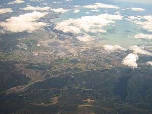
- Monaco – a residential peninsular which juts into the Waimea estuary
- The Stoke Hand – a sculpture outside the Stoke library.
Sport:
- Saxton's Field, an outdoor sports ground which features softball, cricket, football, and hockey fields and also includes a court for netball. There is also an archery programme.
- Saxtons' Stadium, for indoor sports such as futsal, handball, table tennis and volleyball. Home of the basketball team Nelson Giants.
- Nayland Park Pools – include a 50m heated swimming pool and diving pool
Street names
A group of streets in Stoke have been named after famous literary figures. These streets lie between Main Road Stoke and Nayland Road, They include:
Kipling Crescent, Tennyson Crescent, Keats Crescent, Shelley Avenue, Marlowe Street, Browning Crescent, Dickens Street, Homer Street, Coleridge Place
Schools
Primary schools
- Stoke Primary School – founded 1845, the second oldest continuous public school in New Zealand
- Nayland Primary School
- Birchwood Primary School
- Enner Glynn Primary School
Intermediate schools
- Broadgreen Intermediate School
Secondary colleges
- Nayland College.
- a Catholic co-educational secondary school, Garin College, is slightly west of Stoke.
References
- ↑ Stoke Demographics, Nelson City Council. Retrieved 4 September 2015.
- ↑ Reed, A. W. (2010). Peter Dowling, ed. Place Names of New Zealand. Rosedale, North Shore: Raupo. p. 377. ISBN 9780143204107.
- ↑ Goodger, Karen (10 Dec 2010). "Beaut suburb is stoked at being NZ's top place". Nelson Mail. Fairfax New Zealand. Retrieved 2 December 2012.
The Nelson suburb traditionally joked about as being a retirement village is officially New Zealand's favourite place. Stoke was awarded the honour at the Keep New Zealand Beautiful Awards in Parliament last night...
- ↑ Isel House and Park – legacy of the Marsden family The Prow. Retrieved 4 September 2015.
External links
This article is issued from
Wikipedia.
The text is licensed under Creative Commons - Attribution - Sharealike.
Additional terms may apply for the media files.