New Zealand State Highway 2
| ||||
|---|---|---|---|---|
 | ||||
| Route information | ||||
| Maintained by NZ Transport Agency | ||||
| Length | 968 km (601 mi) | |||
| Tourist routes |
Pacific Coast Highway Classic New Zealand Wine Trail | |||
| Major junctions | ||||
| North end |
| |||
|
| ||||
| South end |
| |||
| Location | ||||
| Primary destinations | Paeroa, Waihi, Tauranga, Te Puke, Whakatane, Opotiki, Gisborne, Wairoa, Napier, Hastings, Waipukurau, Dannevirke, Masterton, Carterton, Featherston, Upper Hutt, Lower Hutt | |||
| Highway system | ||||
| ||||

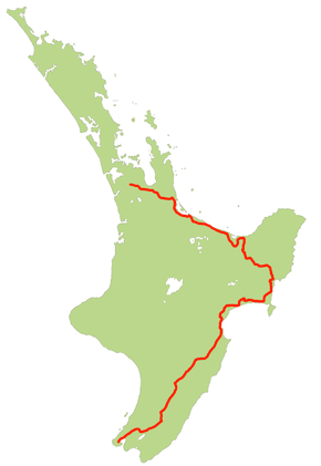
State Highway 2 (SH 2) runs north–south through eastern parts of the North Island of New Zealand from the outskirts of Auckland to Wellington. It runs via Tauranga in the Bay of Plenty, Gisborne, and Napier and Hastings in Hawke's Bay. It is the second-longest highway in the North Island, after State Highway 1, which runs the length of both of the country's main islands.
For most of its length it consists of a two-lane single carriageway, with frequent passing lanes. There are sections of expressway (four lane dual carriageway) at Maramarua, Tauranga and Wellington.
Route

The route that SH 2 took in 2008 is as follows.
SH 2 leaves SH 1 just north of Pokeno, 49 km south of central Auckland. It heads east, crossing the Hauraki Plains before running the length of the Karangahake Gorge, a break in the hills between the Coromandel Peninsula and Kaimai Ranges. From the mining town of Waihi it runs southeast, skirting the edge of Tauranga Harbour, which it crosses on the Tauranga Harbour Bridge before connecting to the 23 km Tauranga Eastern Link, a four lane toll motorway only recently completed. After reaching Paengaroa Junction with SH 33, SH 2 reverts to highway status and follows the coast for a further 34 km, until it reaches the village of Matata.
From Matata it heads slightly inland, crossing the Rangitaiki plain to the south of Whakatane, loops south to Taneatua, through the Waimana gorge and then back north to the coast near Opotiki. After Opotiki it turns inland, ascending southeast along the valley of the Waioeka River, then winding up to the 725-metre Traffords Hill summit. From here it descends into the watershed of the Waipaoa River following the river valley from Te Karaka to Makaraka, just outside Gisborne, to which it is connected by a short stretch of SH 35.
It then turns south, passing the Wharerata Forest and the isthmus of the Mahia Peninsula, turning west to follow the coast of Hawke Bay. Close to the mouth of the Waihua River it heads briefly inland, passing the Mohaka Forest and Lake Tūtira before rejoining the coast not far from the junction with SH 5 at Bay View. It continues south through Napier and turning inland to enter Hastings. From central Hastings it loses its national highway status for seven kilometres as it is cut in two by the Hastings City streets, regaining that status at Pakipaki.
It continues to head inland from Pakipaki, initially southwest to Waipukurau, then briefly west to follow tributaries of the Tukituki River upstream. Close to Norsewood it turns southwest, a direction it maintains for much of the remainder of its journey, crossing undulating country that forms the upper catchment of the Manawatu River. In Woodville, SH 2 meets State Highway 3 at a TOSTO intersection. SH 2 continues south along the Mangatainoka and Makakahi rivers through Pahiatua and Eketahuna, crossing into the Wairarapa valley via the Mount Bruce saddle.
SH 2 follows the Wairarapa valley through the towns of Masterton, Carterton and Greytown to Featherston. The highway then winds through the Remutaka Pass, between the Rimutaka and Tararua Ranges, crossing into the Hutt Valley. SH 2 follows the Hutt River down the valley, passing the cities of Upper Hutt and Lower Hutt to the west, to reach the northern end of Wellington Harbour at Petone. From central Upper Hutt, SH 2 widens to a 2+1 road before widening further to four lanes divided at Silverstream, before finally becoming expressway standard with grade-separated junctions south of Melling. The highway follows the shoreline of Wellington Harbour to Ngauranga and the Ngauranga Interchange, where it terminates onto SH 1.
Although the Ngauranga Interchange is the official end of SH 2, it is signed northbound as far back as the Mount Victoria Tunnel, 8 km before it begins.
Spur sections
SH 2 has one short spur: SH 2B. SH 2B runs for 4.1 km from SH 2 at Napier Airport to SH 50 at Taradale. This forms the northern part of the Hawke's Bay Expressway.
SH 2 used to have an additional spur, SH 2A which ran for 3.8 km from SH 2 through Tauranga, along 15th Avenue and Turret Road, to the junction with SH 29 (now SH 29A) at Maungatapu. This route was once the original route for SH 2 before it was shifted to the newly duplicated Tauranga Harbour Bridge. In August 2015, this state highway lost its full state highway status in conjunction with Takitimu Drive (Route K) Toll Road becoming part of the state highway network.[1]
History
The section of SH 2 through Mangatawhiri had a poor crash record, and the seven-kilometre Mangatawhiri Deviation was opened in December 2008 to improve safety by bypassing it. Passing lanes in both directions provide safe passing opportunities. Grade-separated intersections improve safety for traffic wanting to cross or join the highway.
SH 2 used to follow former SH 2A's route in Tauranga, along 15th Ave, into Turret Road, and across the harbour to Maungatapu, where it joined SH 29, and then headed across the Maungatapu Bridge to Te Maunga. This was changed in 2009 when a second harbour bridge opened next to the current one, providing four lanes of traffic and an overpass from the harbour bridges to the Takitimu Drive expressway. SH 2A became the old section until it was revoked in 2015.
Before August 3, 2015, SH 2 used to travel via Te Puke. The Tauranga Eastern Link, a tolled motorway almost 23 km from Te Maunga Junction to Paengaroa officially opened on July 30, 2015. SH 2 now follows the Tauranga Eastern Link. The new four lane highway was constructed as part of the National government's Roads of National Significance, improving access from the east (Te Puke, Whakatane, Opotiki, Gisborne) and south from Rotorua and Taupo. It is the main route for trucks heading to the Port of Tauranga from Rotorua and the eastern Bay of Plenty, and connects the economically-important central plateau forestry industry with the port for export. This NZTA administered road is tolled at $2.00 for cars and motorcycles and $5.00 for trucks.[2]
SH 2 used to extend into Whakatane, but recently this section was moved inland to pass through Edgecumbe and Awakeri, with SH 30 extended to Whakatane to cover the former route.
SH 2 used to run between Hastings and Pakipaki, but recently has been revoked.
The Rimutaka Hill Road, transversing the Rimutaka Ranges between Featherston and Upper Hutt, has a poor crash record, with many tight 25 and 35 km/h corners, and a lack of safety barriers to prevent vehicles dropping down off the road. The original winding route between Kaitoke and Te Marua was significantly realigned between 2002 and 2006. The tightest and narrowest corner on the road, named Muldoon's Corner after the former Prime Minister's financial stance ("tight and to the right"), is being bypassed with a new wider 55 km/h corner.[3]
River Road, between Maoribank and Silverstream in Upper Hutt, was opened in 1987 to bypass central Upper Hutt. The new route was a two-laned single-carriageway 100 km/h road on the Hutt River's banks, crossing the river at Moonshine, and replaced the 50 km/h route via Fergusson Drive. Most of the road of the road has been widened to three lanes, and median barriers have been installed, with only the Moonshine Bridge and north of Totara Park Drive still having two lanes undivided (Gibbons Street to Totara Park is three lanes undivided).
SH 2's southern terminus has also changed. It formed the southern part of the Wellington Urban Motorway when SH 1 finished at the Aotea Quay off-ramp. In 1996, SH 1 replaced this section.[4]
Future developments
Currently there are several projects to improve SH 2. They include:
- Kopuku Realignment: under investigation to improve to four-lane highway between the Mangatawhiri and Maramarua Deviations. The project is primarily a realignment project aimed at improving road safety and providing passing opportunities.[5]
- Maramarua Deviation: a bypass of Maramarua township, east of the SH 1/2 Pokeno turnoff, to improve road safety, provide passing opportunities and reduce holiday peak congestion in Maramarua township. Design proposals were completed in 2009 but no date had been set for the start of construction. Since 2011 an intermin 90 km/h speed limit has been put in place.[6]
- Waihi to Tauranga Corridor, which consists of four sub-projects:[7]
- Waihi to Omokoroa safety improvements: includes installing run-off barriers and a wide centre line, and improving 26 intersections.
- Katikati Bypass: an investigation is currently being undertaken into the long-standing designation for the bypass to ensure that it will meet the future needs of Katikati, and is consistent with NZTA's overall strategy for long-term management of SH 2.[8]
- Omokoroa to Te Puna Expressway: a 7 km expressway following the existing SH 2 alignment from Omokoroa Road to the Tauranga Northern Link connection at Te Puna. The project includes a grade separated interchange at Omokoroa Road and building parallel local roads to serve existing side roads and driveways.
- Tauranga Northern Link: a 6.8 km deviation bypassing Bethlehem and Te Puna to the south and bisecting SH 29 at the Takitimu Drive Toll Road. The government has pledged funding for secondary investigation work with construction likely to commence in 2018.[9]
- SH2 Wainui Road to Opotiki: Road and roadside safety improvements are proposed from the outskirts of Ohope, along Wainui Road and SH 2 to near Opotiki.[10]
- Motu Bridge Replacement: funding is being fast-tracked to replace the one-lane bridge between Opotiki and Gisborne with a new two-laned bridge.[11]
- Watchman Road intersection: Intersection of SH 2/SH 2B and Watchman Road (a known black spot) is to be upgraded to a roundabout with Watchman Road being extended to provide safer access to Hawke's Bay Airport.[12]
- Melling and Kennedy-Good Bridges and Interchanges: Improved interchanges are planned for the Melling and Kennedy-Good bridges over the Hutt River and the associated interchanges.[13]
Traffic
The busiest section of SH 2 is just north of the Ngauranga Interchange in Wellington, which was measured at km 962 to have an AADT of over 67,000 vehicles both directions.[14] The quietest section of road is near Otoko in the Gisborne District, which was measured at km 390 to have an AADT of fewer than 1000 vehicles.
Major intersections
| Territorial authority | Location | km | jct | Destinations | Notes |
|---|---|---|---|---|---|
| Franklin District | Pokeno | 0 | SH 2 begins | ||
| Waikato District | District contains no major junctions | ||||
| Hauraki District | Mangatarata | 34 | |||
| 37 | |||||
| Paeroa | Waihou River | ||||
| 72 | SH 2/SH 26 concurrency begins | ||||
| 73 | Hamilton, Te Aroha |
SH 2/SH 26 concurrency ends | |||
| Waihi | 93 | SH 2/Pacific Coast Highway concurrency begins | |||
| Western Bay of Plenty District | District west of Tauranga contains no major junctions | ||||
| Tauranga City | |||||
| Tauranga City | 151 | Fifteenth Avenue – Maungatapu, Welcome Bay | Formerly SH 2A. Eastbound exit and westbound entry only. Right-hand exit. | ||
Hamilton, Rotorua |
Westbound exit and eastbound entry only | ||||
| 156 | Tauranga Harbour Bridge | ||||
| Te Maunga | 164 | Tauranga Eastern Link begins | |||
| Papamoa | Domain Road/Te Puke Highway – Papamoa, Te Puke | Toll-free route east via Te Puke Highway | |||
| Western Bay of Plenty District | Rangiuru | Toll point: cars & motorcycles $2.00, heavy vehicles $5.00 | |||
| Paengaroa | 189 | Te Puke Highway – Te Puke |
Tauranga Eastern Link ends Toll-free route west via Te Puke Highway | ||
| Whakatane District | Matata | 223 | Pacific Coast Highway (Arawa Street) – Whakatane, Opotiki | SH 2/Pacific Coast Highway concurrency ends | |
| Hawkens Junction | 232 | ||||
| Edgecumbe | Rangitaiki River | ||||
| Awakeri | 242 | SH 2/SH 30 concurrency begins | |||
| 243 | SH 2/SH 30 concurrency ends | ||||
| Taneatua | 253 | Whakatane River Bridge | |||
| Opotiki District | Kerurutahi | 285 | Pacific Coast Highway (Wainui Road) – Ohope, Whakatane | SH 2/Pacific Coast Highway concurrency begins | |
| Opotiki | 304 | SH 2/Pacific Coast Highway concurrency ends | |||
| Gisborne District | Makaraka | 443 | Pacific Coast Highway (Main Road) – Gisborne, Te Araroa | SH 2/Pacific Coast Highway concurrency begins | |
| Matawhero | 444 | ||||
| Matawhero | 444 | Tiniroto Road – Tiniroto, Wairoa | Former SH 36. | ||
| Wairoa District | North Clyde | 533 | |||
| Hastings District | District north of Napier contains no major junctions | ||||
| Napier City | Bay View | 638 | |||
| Westshore | 647 | ||||
| Watchman Road | |||||
| Napier Central | 649 | SH 2/SH 50 concurrency begins | |||
| 650 | SH 2/SH 50 concurrency ends SH 2/Pacific Coast Highway concurrency ends | ||||
| Hastings District | Karamu | 669 | Kenilworth Road | SH 2 temporarily ends | |
| Pakipaki | 678 | Te Aute Road – Havelock North |
SH 2 resumes | ||
| Central Hawke's Bay District | Waipukurau | 721 | Porangahau Road – Porangahau | Former SH 52 | |
| Takapau | 743 | ||||
| Tararua District | Norsewood | 753 | Manawatu River | ||
| Woodville | 802 | ||||
| Ngawapurua | 808 | Manawatu River | |||
| Masterton District | Lansdowne | 883 | Te Ore Ore Road – Castlepoint, Riversdale Beach | Former SH 52 | |
| Carterton District | District contains no major junctions | ||||
| South Wairarapa District | Greytown | 909 | SH 2/Classic NZ Wine Trail concurrency ends | ||
| Featherston | 921 | SH 2/Classic NZ Wine Trail concurrency begins | |||
| 931 | Remutaka Pass 555 m (1,821 ft) | ||||
| Upper Hutt City | |||||
| Maoribank | 950 | Fergusson Drive – Mangaroa, Upper Hutt City Centre | Hutt Expressway begins | ||
| Hutt City | Manor Park | 962 | [15] | ||
| Wellington City | Ngauranga | 979 | SH 2/Classic NZ Wine Trail concurrency ends | ||
| SH 2 ends Hutt Expressway ends | |||||
SH 2B
| Territorial authority | Location | km | jct | Destinations | Notes |
|---|---|---|---|---|---|
| Napier City | Westshore | 0 | SH 2B begins SH 2B/Hawke's Bay Expressway concurrency begins | ||
| Onekawa | 2.4 | Prebensen Road | |||
| 4.1 | SH 2B ends SH 2B/Hawke's Bay Expressway concurrency ends | ||||
See also
- List of New Zealand state highways
- List of roads and highways, for notable or famous roads worldwide
References
- ↑ "Revoking State Highway and Declaring Sections of State Highway—State Highways 2A and 29, Tauranga". NZ Gazette. 18 June 2015. Retrieved 10 December 2017.
- ↑ "Where the toll roads are". NZTA.
- ↑ "Tight corner on Rimutaka Hill Road consigned to history". New Zealand. 27 June 2011. Retrieved 9 July 2011.
- ↑ "Revoking Section of State Highway State Highway No. 2 and Declaring New Section of State Highway State Highway No. 1". NZ Gazette. Retrieved 12 March 2017.
- ↑ "Kopuku Realignment". NZTA. Retrieved 10 February 2016.
- ↑ "Maramarua Highway Safe System Corridor Project". NZTA. Retrieved 10 February 2016.
- ↑ https://www.nzta.govt.nz/projects/sh2-waihi-to-tauranga-corridor/
- ↑ "SH2 BOP Northern Corridor Safe System project". NZTA. Retrieved 10 February 2016.
- ↑ "$520m bypass for busy Tauranga bottleneck". Bay of Plenty Times. 22 April 2016.
- ↑ "SH2 Wainui Road to Opotiki". NZTA. 3 March 2017.
- ↑ "Motu Bridge replacement confirmed". 27 January 2016.
- ↑ "Sod turned on Watchman Road Intersection Improvement project". Scoop.co.nz. 20 April 2017. Retrieved 23 April 2017.
- ↑ "SH2 Melling to Haywards upgrade". NZTA. 26 April 2015.
- ↑ "State highway traffic volumes 2011-2015" (PDF). NZ Transport Agency. Retrieved 23 April 2016.
- ↑ "Traffic to start using new Haywards interchange from next weekend". Transport for Wellington. 12 April 2017. Retrieved 23 April 2017.
External links
| National | ||
|---|---|---|
| North Island |
| |
| South Island | ||
| Former state highways | ||
| Touring routes |
| |