Bruce Bay
| Bruce Bay | |
|---|---|
| Settlement | |
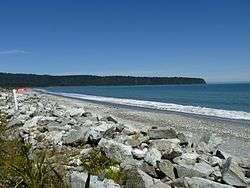 View across Bruce Bay to Heretaniwha | |
 Bruce Bay | |
| Coordinates: 43°36′S 169°34′E / 43.600°S 169.567°E | |
| Country | New Zealand |
| Region | West Coast |
| District | Westland District |
| Electorates |
West Coast-Tasman Te Tai Tonga |
| Population (2013) | |
| • Total | 33 (Bruce Bay to Paringa) |
| Time zone | UTC+12 (NZST) |
| • Summer (DST) | UTC+13 (NZDT) |
| Postcode | 7886 |
| Area code(s) | 03 |
| Local iwi | Ngāi Tahu |
Bruce Bay or Mahitahi is a bay in South Westland, New Zealand on the Tasman Sea. It is south of the mouth of the Mahitahi River, 80 km from Haast Junction and 224 km from Hokitika.[1] The bay is a nesting ground for local penguins, and endemic Hector's dolphins and southern right whales can be observed from shores on occasions.[2] Some of the bush around the bay has been cleared for farming, and quartz stones can be found on the coast.[3]
Bruce Bay was the location of The Hunt's Duffer Gold Rush in 1866. Prospector Albert Hunt who had found gold at Greenstone near Hokitika was granted a claim some 10 km south of the bay and 15 km inland. He was watched by a mob of 500 diggers at Ōkārito who on 26 March forced Hunt to lead them to the claim. He managed to escape, was recaptured and escaped again. By then there were more than 1500 men camped at Bruce Bay. When the angry mob arrived back at the bay, Warden Price was threatened and in the riot that night six makeshift stores were demolished and ransacked.[4][1]
The following day, Price swore in special constables at Ōkārito. The ringleaders William Quinlan and William Ryan were charged at Hokitika for causing damage to the extent of £664 on freehold property, but the case lapsed as the stores were all on leased land. Weld Town, the township at Bruce Bay which had a floating population of over 2000 collapsed as the diggers moved north, although there were still 300 hopefuls there three weeks later.[4][1]
Several claims were later established on the coast and inland from Ōkārito (then Westland's third port and centre) to Bruce Bay, with a total population of over 3000 and a peak output in June 1866 of over 12,000 ounces. The largest townships south of Ōkārito were Five Mile Beach and Gillespies with 40 and 11 stores respectively. But the beach-workings and Ōkārito collapsed in late 1866, after a run on the Bank of New Zealand at Ōkārito and Ross in July.[4][1]
Te Tauraka Waka a Māui Marae opened at Bruce Bay in January 2005.[5][6] It is the marae (tribal meeting ground) of the Kāti Māhaki ki Makaawhio hapū (sub-tribe) of Ngāi Tahu, and includes a wharenui (meeting house) called Kaipō.[7][8]
References
- 1 2 3 4 South Island: Mobil New Zealand Travel Guide by Diana and Jeremy Pope, pages 390-91 (7th edition, 1997; Reed, Wellington)
- ↑ "Bruce Bay Cairns New Zealand". talkingbeatifulstuff.com. Talking Beautiful Stuff.
- ↑ "Bruce Bay". westlanddc.govt.nz. Westland District Council.
- 1 2 3 The West Coast Gold Rushes by Philip Ross May, pages 175-76 & 188-91 (1962, Pegasus Press, Christchurch)
- ↑ Devereux, Monique (22 January 2005). "Large gathering to watch opening of remote marae". New Zealand Herald. Retrieved 18 July 2013.
- ↑ Opening of Te Tauraka Waka a Māui marae. Te Ara Encyclopedia of New Zealand. Retrieved 18 July 2013.
- ↑ "Te Kāhui Māngai directory". tkm.govt.nz. Te Puni Kōkiri.
- ↑ "Māori Maps". maorimaps.com. Te Potiki National Trust.