Kawarau River
| Kawarau River | |
|---|---|
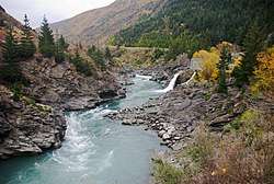 Kawarau River with Roaring Meg hydro station | |
| Country | New Zealand |
| Physical characteristics | |
| Main source | Lake Wakatipu |
| River mouth | Lake Dunstan |
| Length | 60 km (37 mi) |
The Kawarau River drains Lake Wakatipu in northwestern Otago, New Zealand. The river flows generally eastwards for about 60 kilometres (37 mi) and passes through the steep Kawarau Gorge until it joins Lake Dunstan near Cromwell. The Shotover River enters it from the north; the Nevis River enters it from the south. With many rapids and strong currents, the river can be dangerous and has claimed many lives: it is also popular for bungy jumping and kayaking.
A natural bridge, "Whatatorere", where the river narrows to 1.2 metres (3.9 ft), was important first to early Māori and then to goldminers as the only place the Clutha and Kawarau rivers could be crossed without boats. Māori were heading for the Cardrona valley to reach Wanaka, and on to the Haast Pass to seek pounamu. The miners were seeking gold in the Arrow Goldfields.[1]
Now, the main road to Queenstown, SH6, runs through the Kawarau Gorge.
Name
Kawarau is a Māori name meaning many shrubs.[2] However the current shrubs around the river are largely of exotic origin and likely to be different from the original native bushes that the name came from.
The name would normally be pronounced to rhyme approximately with "now" as in "Māori", but is often pronounced by locals as if it were "K'worra", possibly influenced by the southern dialect of Māori. It should not be confused with the Bay of Plenty town of Kawerau.
History
In the 19th century, alluvial gold was extracted from the river. The Goldfields Mining Centre, downstream of the gorge, features a working exhibition of 19th century gold mining techniques.[3] Some of the miners' huts remain today, many of them close to thriving vineyards.
In 1924 a company was formed to drain the river by blocking off Lake Wakatipu, with the intent of then collecting gold from the river bed. Ten massive gates were completed in 1927 and although the river level dropped it was not laid bare as planned. The gates now form part of State Highway 6.[1]
The Roaring Meg Hydro Scheme discharges into the Kawarau just upstream from the Whatatorere narrows.
Water Conservation Order
A Water Conservation Order protects the river for its wild and scenic character, natural characteristics, scientific values and for recreational use. No damming of the river is allowed and the water must be maintained to a specific standard.
The Water conservation Order covers the stretch of river from the Lake Wakatipu control gates to Scrubby Stream.[4] Fish and Game has sought an amendment to the Water Conservation Order to prevent any damming of the Nevis River and to seek conditions on changes to the minimum flows.[5]
Adventure tourism
The first European to visit the area was Nathaniel Chalmers, who was guided inland by Chiefs Reko and Kaikoura in 1853.[6] Reko and Kaikoura showed Chalmers the rock bridge "Whatatorere" at Roaring Meg, which was the only place that the Kawarau River could be crossed,[7] and returned him down the Clutha in a flax reed boat.
| Early adventure tourism? |
|---|
| In 1910, 57 years after the event, Nathanael Chalmers remembered his raft trip through the Cromwell Gorge: ‘I shall never forget the “race” through the gorge … my heart was literally in my mouth, but those two old men seemed to care nothing for the current.’ [8] |
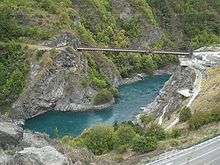
Tourist adventure activities on the river include riverboarding, jet boating, white water rafting, river surfing, and bungy jumping. The Kawarau Gorge Suspension Bridge, 43 metres (141 ft) above the river, and a Category I historic place,[9] is the site of the world's first commercial bungy jumping operation. Eastburn Station gave up the 1.2 square kilometres (300 acres) plus that forms the natural backdrop as a reserve.
The Kawarau is the largest volume river commercially rafted in New Zealand, with an average flow of 216 cubic metres per second (7,600 cu ft/s) at Chards Road measuring station.[10] The four significant commercially used rapids on the river are Smiths Falls, Twin Bridges, Do Little Do Nothing and the 400-metre (1,300 ft) Chinese Dog Leg. Below these are the dangerous Nevis Bluff, Citroen and Roaring Meg sections. Because of the danger Waitiri Station usually declines access.[11]
In popular culture
The Kawarau featured as a setting for the Argonath in the 2001 motion picture, The Lord of the Rings: The Fellowship of the Ring.
Frederick John Cato of the firm Moran & Cato, was a teacher from Invercargill, New Zealand, where he met and married Frances Bethune. They named their expansive home in Tooronga Rd, Hawthorn East, Victoria, Australia; "Kawarau".
On 25 September 2008, a Chinese tourist died in a jet boat accident at the confluence with the Shotover. The Kawarau Jet boat flipped after hitting a sandbar, leaving one passenger trapped underneath, and putting the remaining 21 and driver into the river.[12]
Bridges
Bridges that pass over the Kawarau River are:
- Kawarau Gorge Suspension Bridge
- Kawarau River Bridge
- Kawarau River (Victoria) Bridge
- Kawarau Falls Bridge
- Bridge at the Goldfields Mining Centre
Until it was destroyed in the 19th century, the natural rock bridge "Whatatorere" at Roaring Meg was the only place that the Kawarau River and Clutha River / Mata-Au could be crossed without boats.[7]
See also
| Wikimedia Commons has media related to Kawarau River. |
References
- 1 2 Cromwell Handbook 2nd edition Archived 2007-09-30 at the Wayback Machine.
- ↑ Pires, Dhavidy. "Kawarau River".
- ↑ http://www.goldfieldsmining.co.nz/
- ↑ "WATER CONSERVATION (KAWARAU) ORDER 1997". New Zealand Government. 1997-03-17. Archived from the original (text) on 2008-10-14. Retrieved 2008-07-18.
- ↑ "Application to vary the Water Conservation (Kawarau) Order 1997 in respect of the Nevis River". Ministry for the Environment. Retrieved 2008-12-06.
- ↑ Jock Phillips. "European exploration - Otago and Southland". Te Ara - the Encyclopedia of New Zealand. Retrieved 2017-07-11.
- 1 2 Janet Stephenson, Heather Bauchop, and Peter Petchey (2004). Bannockburn Heritage Landscape Study (PDF). p. 29.
- ↑ Philip Temple (1985). New Zealand explorers: great journeys of discovery. Christchurch: Whitcoulls. p. 110.
- ↑ "Kawarau Gorge Suspension Bridge". Register of Historic Places. Heritage New Zealand. Retrieved 2008-09-23.
- ↑ Otago Regional Council monthly river flow data: http://www.orc.govt.nz/portal.asp?categoryid=98
- ↑ http://www.rafting.com/kawarau-river-rafting.htm
- ↑ "Tourist killed in jetboat crash named". Otago Daily Times. 29 September 2008. Retrieved 2008-09-29.