Wanaka
| Wanaka Wānaka (Māori) | |
|---|---|
| Town | |
 Wanaka Location of Wanaka within New Zealand | |
| Coordinates: 44°42′S 169°09′E / 44.700°S 169.150°ECoordinates: 44°42′S 169°09′E / 44.700°S 169.150°E | |
| Country | New Zealand |
| Region | Otago |
| Territorial authority | Queenstown Lakes District |
| Area | |
| • Total | 28.61 km2 (11.05 sq mi) |
| Elevation | 290 m (950 ft) |
| Population (June 2018)[1] | |
| • Total | 8,890 |
| • Density | 310/km2 (800/sq mi) |
| Time zone | UTC+12 (NZST) |
| • Summer (DST) | UTC+13 (NZDT) |
| Postcode | 9305 |
| Area code | 03 |
| Local iwi | Ngāi Tahu |
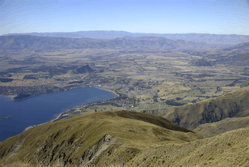
Wanaka /ˈwɒnəkə/ (Māori: Wānaka) is a popular ski and summer resort town in the Otago region of the South Island of New Zealand. At the southern end of Lake Wanaka, it is at the start of the Clutha River and is the gateway to Mount Aspiring National Park.
Wanaka is primarily a resort town with both summer and winter seasons. Its economy is based on the many outdoor opportunities this offers.
Historically, Maori visited the Wanaka area to hunt and fish in summer, or on their way to seek pounamu on the West Coast. Ngai Tahu abandoned their seasonal camps after a raid by a North Island war party in 1836. The current town was founded during the gold rush of the 19th century. Along with the rest of the Queenstown-Lakes District, Wanaka is growing rapidly, with the population increasing by 50% between 2005 and 2015.
History
Wanaka was visited annually by Ngai Tahu who sought greenstone in the mountains above the Haast River and hunted eels and birds over summer, returning to the east coast by descending the Clutha River / Mata-Au in reed boats called mōkihi.[2][3] Ngai Tahu use of the land was ended by attacks by North Island tribes. In 1836, the Ngati Tama chief Te Puoho led a 100-person war party, armed with muskets, down the West Coast and over the Haast Pass: they fell on the Ngai Tahu encampment between Lake Wanaka and Lake Hawea, capturing 10 people and killing and eating two children.[4] Some of the Ngai Tahu fled down the Waitaki river to the coast; Te Puoho took his captives over the Crown Range to Lake Wakatipu and thence to Southland where he was killed and his war party destroyed by the southern Ngai Tahu leader Tuhawaiki.[5]
The first European to visit the area was Nathaniel Chalmers, who was guided inland by Chiefs Reko and Kaikoura in 1853.[6] Reko and Kaikoura showed Chalmers the rock bridge "Whatatorere" at Roaring Meg, which was the only place that the Kawarau River could be crossed,[7] and returned him down the Clutha in a flax reed boat.
European settlement began in the Upper Clutha River Valley in the 1850s, with the establishment of sheep stations by runholders. The first station was at Albert Town, the only place where settlers could ford the Clutha River. The present site of Wanaka was first surveyed in 1863,[8] and settlement increased in Pembroke (the old name for Wanaka) during the 1870s because of timber milling in the Matukituki Valley and the use of Lake Wanaka for transport.
Tourism began in 1867 with the opening of the first hotel, by Theodore Russell, and the world's first sheepdog trials.[9]
The town of Pembroke was renamed Wanaka in 1940.[8] Wanaka proved a very popular tourist destination because of its borderline continental climate and easy access to snow and water.[10]
Geography

The town of Wanaka is situated at the southern end of Lake Wanaka, surrounded by mountains. To the southwest is the Crown Range and town of Queenstown (120 kilometres (75 mi)); to the north the Haast Pass cuts through the Southern Alps near Makarora. To the northeast are the towns of Omarama and Twizel. Very close to Lake Wanaka is Lake Hāwea, in a parallel glacial valley, which has a recently developed settlement of about 1,500 people. To the south of the town lies more of the Southern Alps. The Glendhu Bay motorpark is close to the town, leading into the Matukituki River valley which gives access to the Mount Aspiring National Park.
The centre of the town lies on flat land beside Roy's Bay. Parts of the town have expanded into the hills surrounding the centre and around Roy's Bay in both directions. The lakeside area of the town is prone to occasional flooding in spring, when heavy rain and snowmelt can cause the lake to rise quickly, as in November 1999.[11][12]
Climate
Despite its oceanic climate, Wanaka is one of the few areas in New Zealand to enjoy a semi-continental climate, with four distinct seasons. The weather is fairly dry, with spring (September–December) being the wettest season. Annual rainfall is 682 mm which is half the national average. Wanaka's summers are warm, with temperatures reaching the high 20s and an average summer maximum of 24 °C (75 °F). Wanaka's highest-ever temperature of 35.2 °C (95.4 °F) was recorded in January 2018.[13]
Winter can be extreme by New Zealand standards with temperature mostly in the single digits during the day time followed by cold and frosty nights and frequent snowfalls.
| Climate data for Wanaka | |||||||||||||
|---|---|---|---|---|---|---|---|---|---|---|---|---|---|
| Month | Jan | Feb | Mar | Apr | May | Jun | Jul | Aug | Sep | Oct | Nov | Dec | Year |
| Average high °C (°F) | 23.9 (75) |
23.4 (74.1) |
20.8 (69.4) |
17.3 (63.1) |
12.2 (54) |
8.4 (47.1) |
8.4 (47.1) |
11.0 (51.8) |
14.4 (57.9) |
16.8 (62.2) |
19.8 (67.6) |
21.9 (71.4) |
16.5 (61.7) |
| Average low °C (°F) | 10.8 (51.4) |
10.4 (50.7) |
8.4 (47.1) |
5.1 (41.2) |
1.6 (34.9) |
−0.9 (30.4) |
−1.2 (29.8) |
−0.2 (31.6) |
2.4 (36.3) |
5.0 (41) |
7.3 (45.1) |
9.6 (49.3) |
4.9 (40.7) |
| Average precipitation mm (inches) | 56.9 (2.24) |
50.2 (1.976) |
60.7 (2.39) |
56.4 (2.22) |
62.7 (2.469) |
54.5 (2.146) |
52.2 (2.055) |
52.8 (2.079) |
56.4 (2.22) |
63.1 (2.484) |
54.7 (2.154) |
51.9 (2.043) |
672.5 (26.476) |
| Mean monthly sunshine hours | 231.5 | 201.7 | 182.6 | 164.0 | 135.5 | 120.5 | 126.6 | 155.8 | 172.5 | 193.8 | 202.2 | 212.1 | 2,098.8 |
| Source: http://www.lakewanaka.co.nz/content/library/Weather_data.pdf | |||||||||||||
Wanaka wine sub-region
The area around Wanaka is a formal sub-region of the Central Otago wine region with several top wineries and vineyards. As with other parts of the wine region, the main grape variety in the area is pinot noir.
Attractions
With its lake and mountain views, Wanaka has become a popular tourist resort, considered less commercialised than Queenstown.[14]
Wanaka boasts a growing number of restaurants, cafes and a diverse nightlife. Other attractions in the town include Puzzling World and the Paradiso Cinema. Puzzling World contains a maze, optical illusions and a leaning clocktower.[15] The Paradiso is a classic old cinema, with seating consisting of old couches and an in-theatre Morris Minor.[16] There are a number of wineries in the area. Just out of town next to the Wanaka Airport is the National Transport and Toy Museum.
In winter, Wanaka is an excellent place to see the Southern Lights.[17]
A number of mountains surrounding Wanaka can be climbed, including Roys Peak, Mount Iron, Mount Grand and the Pisa Range, all of which provide views of the surrounding area.
Festivals
- The biennial Warbirds over Wanaka airshow has become a major attraction for national and international guests.
- Wanakafest[18]
- NZ Freeski open
- The biennial New Zealand music Rippon Festival[19]
- Challenge Wanaka Triathlon Festival[20]
- Festival of Colour[21] and Aspiring Conversations. Two festivals organised by the Southern Lakes Arts Festival Trust. The Festival of Colour is a biennial multi disciplinary arts festival featuring theatre, music, dance and visual arts. Aspiring Conversations is an ideas festival. Both are timed for April in alternate years.
- Rhythm and Alps[22]
Film Locations
The Wanaka region has been the setting for many international films, including The Lord of the Rings,[23], The Hobbit,[24], the Legend of S,[25] and A Wrinkle in Time.[26]
Summer
Wanaka is host to outdoor recreation and tourism activities with hiking, mountain biking, mountaineering, rock climbing, fishing, paragliding, kayaking, rafting, jetboating, and environmental activities. Wanaka has a sunny climate and serves as an access point to the highest New Zealand mountain outside of the Mount Cook region: Mount Aspiring/Tititea.
Mount Aspiring National Park is popular for mountaineering and hiking. Tourists enjoy day trips into the park and many tourists go hiking in the park for up to a week at a time. Parts of the Matukituki Valley on the road to the park are popular for rock climbing, and for day walks.
Lake Wanaka itself is popular for waterskiing, wakeboarding and sailing. This along with the local rivers provide many opportunities for fishing. There is a dedicated mountain biking area made by volunteers in a local pine forest.[28] Adjacent to the bike park is an 18-hole disc golf course. All the local ski resorts are open for mountain biking and hiking in the summer.
Winter

Wanaka has the broadest range of snow activity choices of any town in NZ. These include Treble Cone, Cardrona Alpine Resort, Snow Park and Snow Farm, some of New Zealand's premier commercial ski fields. Wanaka is the main accommodation provider for these resorts and so is very busy in high season (July–September).
Treble Cone has good lift-accessed terrain and for this reason has become popular amongst visitors, 'ConeHeads'.[29] It also catches some of the better snow in the area, with its location and orientation getting more snow from NW storms.
Cardrona is more attractive to families and beginners, though an attempt has been made at the park riding population in competition with SnowPark.[30] Snowpark is a dedicated 100% artificial terrain park for advanced riders. Snow Farm is New Zealand's only commercial cross-country ski field.
Cardrona also hosts one of the few Olympic sized halfpipes in the world and has been used for practice for Olympic competition.[31]
People
Wanaka is home to 8,890 people as of June 2018.[1] It is the country's 36th-largest urban area and the fourth-largest urban area in Otago behind Dunedin, Queenstown and Oamaru.
| Historical population | ||
|---|---|---|
| Year | Pop. | ±% p.a. |
| 1996 | 2,600 | — |
| 2001 | 3,450 | +5.82% |
| 2006 | 5,280 | +8.88% |
| 2013 | 6,820 | +3.72% |
| Source: [32] | ||
The 2013 census counted 6,471 permanent residents in the Wanaka urban area, 28.4 percent more than seven years earlier. The median age of residents was 41.1 years; around 16.7% of residents were aged 65 or over and 18.5% were aged 14 or younger. In terms of ethnicity, Wanaka has a largely homogeneous population; 93.5 percent of people identified as European and 5.0 percent as Māori.[33]
52.4% of the town's population had some form of post school qualification, 12.5% above the national average. The unemployment rate was exceptionally low in Wanaka, at 1.9%, compared to 5.1% for New Zealand.[34] Over half (54.1%) of families in Wanaka were couples with no dependent children; couples with dependent children made up 36.9 percent of families, and single parents with dependent children made up 8.8 percent.[33]
Government
Nationally, Wanaka is part of the Waitaki electorate, represented by the New Zealand National Party's Jacqui Dean since 2005.[35]
Wanaka's local governments are the Queenstown-Lakes District Council[36] and the Otago Regional Council.[37]
Education
Wanaka has three schools.
- Holy Family School is a state-integrated Catholic full primary (Year 1–8) school, and has 189 students as of August 2018.[38] The school was established in 2006.
- Mount Aspiring College is a state Year 7–13 secondary school, and has 1009 students as of August 2018.[38] The school was established in 1986 following the split of Wanaka Area School.
- Wanaka Primary School is a state contributing primary (Year 1–6) school, and has 734 students as of August 2018.[38] The school was established in 1986 following the split of Wanaka Area School, and relocated to its current site in October 2010.
Transport
Wanaka is served by the Wanaka Airport as well as by roads over the Crown Range, through the Haast Pass to the West Coast, to Mt Cook via the Lindis Pass to the north, and south through Cromwell by State Highway 6. There are daily bus services to Christchurch, Dunedin, Queenstown, Invercargill and Greymouth.
During the early 20th century an unsuccessful proposal was made for the Otago Central Railway, then terminated at Cromwell, to be extended to Wanaka and onward to Hāwea.[39] The main reason for NZR's reluctance was having to cross the Clutha River twice. A more direct route to Hāwea was planned but dropped due to cost.
References
- 1 2 "Subnational Population Estimates: At 30 June 2018 (provisional)". Statistics New Zealand. 23 October 2018. Retrieved 23 October 2018. For urban areas, "Subnational population estimates (UA, AU), by age and sex, at 30 June 1996, 2001, 2006-18 (2018 boundary)". Statistics New Zealand. 23 October 2018. Retrieved 23 October 2018.
- ↑ Malcolm McKinnon. "Otago region - Māori history and whaling". Te Ara - the Encyclopedia of New Zealand. Retrieved 2017-07-11.
- ↑ Hoturoa Barclay-Kerr. "Waka – canoes - Other types of waka". Te Ara - the Encyclopedia of New Zealand. Retrieved 2017-07-11.
- ↑ S Percy Smith (1910). History and Traditions of the Maoris of the West Coast North Island of New Zealand Prior to 1840. New Plymouth: Polynesian Society.
- ↑ Atholl Anderson (1990). "Te Puoho-o-te-rangi". Te Ara - the Encyclopedia of New Zealand,. 1. Retrieved 2017-07-11.
- ↑ Jock Phillips. "European exploration - Otago and Southland". Te Ara - the Encyclopedia of New Zealand. Retrieved 2017-07-11.
- ↑ Janet Stephenson, Heather Bauchop, and Peter Petchey (2004). Bannockburn Heritage Landscape Study (PDF). p. 29.
- 1 2 "Wanaka Early History". Lake Wanaka Visitor Information Centre. Retrieved 2007-03-24.
- ↑ "World First Recorded Trial". Malborough, New Zealand: DogFind.
- ↑ "Wanaka Information Guide".
- ↑
- ↑
- ↑ Stuff. "Hottest ever recorded temperature in Wanaka".
- ↑
- ↑ "Welcome to Wanaka's Wonderful World of Weirdness!". Puzzling World. Retrieved 2017-01-21.
- ↑ "Cinema Paradiso | Home". Paradiso.net.nz. Retrieved 2017-01-21.
- ↑ "Severe geomagnetic storm lights up sky". Stuff.co.nz. Retrieved 2017-01-21.
- ↑ "Wanakafest 2015 | Wanaka family festival events & live music!". Wanakafest.co.nz. Retrieved 2017-01-21.
- ↑ "Rippon Open Air Festival 2014". Ripponfestival.co.nz. 2014-02-01. Retrieved 2017-01-21.
- ↑ "Challenge Wanaka, Lake Wanaka, New Zealand". Challenge-wanaka.com. 2016-12-19. Retrieved 2017-01-21.
- ↑ "Festival of Colour". Festival of Colour. Retrieved 2017-01-21.
- ↑ "Rhythm & Alps - New Years Music Festival Wanaka, New Zealand". Rhythmandalps.co.nz. Retrieved 2017-01-21.
- ↑ "The Lord of the Rings Location: Tarras & Wanaka".
- ↑ "The Hobbit Trilogy Filming Locations".
- ↑ Otago Daily Times. "Chinese fantasy filming in Wanaka". Retrieved 27 January 2018.
- ↑ "Witherspoon, Winfrey and Kaling in Wanaka and Lake Hawea".
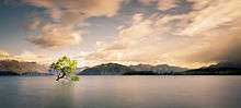
- ↑ "#ThatWanakaTree through the seasons". YouTube. 2015-02-09. Retrieved 2017-01-21.
- ↑ "Lake Wanaka Cycling". 9 June 2008.
- ↑ "Treble Cone, Wanaka, New Zealand". 14 August 2006.
- ↑ "Welcome | Cardrona NZ". Cardrona.com. 2016-04-03. Retrieved 2017-01-21.
- ↑ "Snowboarding at the Cardrona Halfpipe - Video". The New York Times. 40.755978;-73.990396. Retrieved 2017-01-21.
- ↑ "Infoshare; Group: Population Estimates - DPE; Table: Estimated Resident Population for Urban Areas, at 30 June (1996+) (Annual-Jun)". Statistics New Zealand. Retrieved 17 June 2015.
- 1 2 "2013 Census QuickStats about a place: Wanaka". Statistics New Zealand. Retrieved 18 June 2015.
- ↑ 2006 Census figures, taken from Quickstats about Wanaka and compared to national figures at Quickstats about New Zealand
- ↑ "Official Count Results - Waitaki". Electionresults.govt.nz. 2008-11-22. Retrieved 2017-01-21.
- ↑ "Queenstown-Lakes District Council".
- ↑ "Otago Regional Council".
- 1 2 3 "Directory of Schools - as at 13 September 2018". New Zealand Ministry of Education. Retrieved 22 September 2018.
- ↑ Over the Garden Wall : The Story of the Otago Central Railway, James Albert Dangerfield, George West Emerson; New Zealand Railway and Locomotive Society (Otago Branch), 1967