National Register of Historic Places listings in Stafford County, Kansas
Location of Stafford County in Kansas
This is a list of the National Register of Historic Places listings in Stafford County, Kansas. It is intended to be a complete list of the properties and districts on the National Register of Historic Places in Stafford County, Kansas, United States. The locations of National Register properties and districts for which the latitude and longitude coordinates are included below, may be seen in an online map.
There are 9 properties and districts listed on the National Register in the county.
- This National Park Service list is complete through NPS recent listings posted October 4, 2018.[1]
Current listings
| [2] | Name on the Register[3] | Image | Date listed[4] | Location | City or town | Description |
|---|---|---|---|---|---|---|
| 1 | Comanche Archeological Site | September 18, 1978 (#78001290) |
Western edge of the Quivira National Wildlife Refuge Address Restricted |
Stafford | ||
| 2 | Covenanter Church | 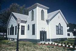 |
June 8, 2005 (#05000544) |
113 N. Green St. 37°57′46″N 98°36′21″W / 37.962778°N 98.605833°W |
Stafford | |
| 3 | Farmers National Bank | 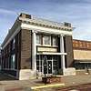 |
May 17, 2006 (#06000392) |
100 N. Main 37°57′43″N 98°35′59″W / 37.961944°N 98.599722°W |
Stafford | |
| 4 | First Methodist Episcopal Church | 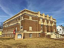 |
October 31, 2002 (#02001264) |
219 W. Stafford 37°57′49″N 98°36′09″W / 37.963611°N 98.6025°W |
Stafford | |
| 5 | William R. Gray Photography Studio and Residence | 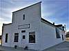 |
January 2, 2013 (#12001121) |
116 N. Main 37°59′59″N 98°45′42″W / 37.999705°N 98.76162°W |
St. John | |
| 6 | Sarah L. Henderson House | 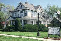 |
July 19, 1996 (#96000763) |
518 W. Stafford St. 37°58′21″N 98°36′18″W / 37.9725°N 98.605°W |
Stafford | |
| 7 | Nora E. Larabee Memorial Library | 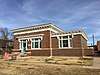 |
May 11, 2006 (#06000391) |
108 N. Union St. 37°57′44″N 98°36′06″W / 37.962234°N 98.601717°W |
Stafford | |
| 8 | Martin Cemetery | October 5, 2015 (#15000692) |
US 50, 1/4 mi. W. of US 281 37°57′22″N 98°46′29″W / 37.9562°N 98.7746°W |
St. John | ||
| 9 | Joseph L. Spickard House | 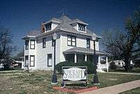 |
June 8, 2005 (#05000546) |
201 N. Green St. 37°57′48″N 98°36′21″W / 37.963333°N 98.605833°W |
Stafford |
See also
References
- ↑ "National Register of Historic Places: Weekly List Actions". National Park Service, United States Department of the Interior. Retrieved on October 4, 2018.
- ↑ Numbers represent an ordering by significant words. Various colorings, defined here, differentiate National Historic Landmarks and historic districts from other NRHP buildings, structures, sites or objects.
- ↑ National Park Service (2010-07-09). "National Register Information System". National Register of Historic Places. National Park Service.
- ↑ The eight-digit number below each date is the number assigned to each location in the National Register Information System database, which can be viewed by clicking the number.
External links
| Wikimedia Commons has media related to National Register of Historic Places in Stafford County, Kansas. |


| Topics | |
|---|---|
| Lists by states |
|
| Lists by insular areas | |
| Lists by associated states | |
| Other areas | |
| |
Municipalities and communities of Stafford County, Kansas, United States | ||
|---|---|---|
| Cities | | |
| Unincorporated communities | ||
This article is issued from
Wikipedia.
The text is licensed under Creative Commons - Attribution - Sharealike.
Additional terms may apply for the media files.