National Register of Historic Places listings in Lincoln County, Kansas
Location of Lincoln County in Kansas
This is a list of the National Register of Historic Places listings in Lincoln County, Kansas.
This is intended to be a complete list of the properties on the National Register of Historic Places in Lincoln County, Kansas, United States. The locations of National Register properties for which the latitude and longitude coordinates are included below, may be seen in a map.[1]
There are 12 properties listed on the National Register in the county.
- This National Park Service list is complete through NPS recent listings posted October 4, 2018.[2]
Current listings
| [3] | Name on the Register[4] | Image | Date listed[5] | Location | City or town | Description |
|---|---|---|---|---|---|---|
| 1 | Archeological Site Number 14LC306 | July 9, 1982 (#82004882) |
Address restricted |
Lincoln | ||
| 2 | Bullfoot Creek Bridge | July 2, 1985 (#85001421) |
4 miles south and 0.9 miles east of Vesper 38°58′25″N 98°15′39″W / 38.973611°N 98.260833°W |
Vesper | ||
| 3 | Cummins Block Building | 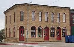 |
March 24, 2000 (#00000268) |
161 E. Lincoln 39°02′24″N 98°08′47″W / 39.039999°N 98.146258°W |
Lincoln | |
| 4 | Danske Evangelist Lutheran Kirke | _from_W_1.JPG) |
September 12, 1991 (#91001154) |
Between Trail and Timber Creeks due east of Denmark 39°05′22″N 98°16′42″W / 39.089407°N 98.278351°W |
Grant Township | Built c.1875-1880; bell tower and steeple added in 1901. |
| 5 | Evangelical Lutheran School | October 2, 2015 (#15000690) |
308 N. Indiana St. 39°00′49″N 98°23′16″W / 39.0137°N 98.3879°W |
Sylvan Grove | ||
| 6 | Lincoln Carnegie Library | 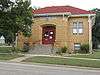 |
June 25, 1987 (#87000957) |
203 S. 3rd 39°02′21″N 98°08′41″W / 39.039167°N 98.144722°W |
Lincoln | |
| 7 | Lincoln County Courthouse | 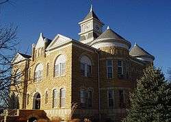 |
July 13, 1976 (#76000825) |
3rd and Lincoln Ave. 39°02′27″N 98°08′41″W / 39.040833°N 98.144722°W |
Lincoln | |
| 8 | Marshall-Yohe House |  |
April 19, 2001 (#01000386) |
316 S. 2nd St. 39°02′15″N 98°08′41″W / 39.037627°N 98.14472°W |
Lincoln | |
| 9 | Nielsen Farm | January 11, 2006 (#05001513) |
1125 E. Pike Dr. 39°05′02″N 98°17′37″W / 39.083889°N 98.293611°W |
Sylvan Grove | ||
| 10 | Salt Creek Truss Leg Bedstead Bridge | May 9, 2003 (#03000368) |
B Rd., 0.6 mile east of its intersection with 24th Rd., 1.0 mile north of Barnard 39°12′17″N 98°02′57″W / 39.204722°N 98.049167°W |
Barnard | ||
| 11 | Spring Creek Tributary Bridge | July 2, 1985 (#85001440) |
8 miles south and 5 miles west of Lincoln 38°54′32″N 98°14′38″W / 38.908889°N 98.243889°W |
Lincoln | ||
| 12 | Sylvan Grove Union Pacific Depot | April 2, 2014 (#14000118) |
131 S. Main St. 39°00′34″N 98°23′34″W / 39.009449°N 98.392871°W |
Sylvan Grove | Part of the Railroad Resources of Kansas MPS |
See also
| Wikimedia Commons has media related to National Register of Historic Places in Lincoln County, Kansas. |
References
- ↑ The latitude and longitude information provided in this table was derived originally from the National Register Information System, which has been found to be fairly accurate for about 99% of listings. For about 1% of NRIS original coordinates, experience has shown that one or both coordinates are typos or otherwise extremely far off; some corrections may have been made. A more subtle problem causes many locations to be off by up to 150 yards, depending on location in the country: most NRIS coordinates were derived from tracing out latitude and longitudes from USGS topographical quadrant maps created under the North American Datum of 1927, which differs from the current, highly accurate WGS84 GPS system used by most on-line maps. Chicago is about right, but NRIS longitudes in Washington are higher by about 4.5 seconds, and are lower by about 2.0 seconds in Maine. Latitudes differ by about 1.0 second in Florida. Some locations in this table may have been corrected to current GPS standards.
- ↑ "National Register of Historic Places: Weekly List Actions". National Park Service, United States Department of the Interior. Retrieved on October 4, 2018.
- ↑ Numbers represent an ordering by significant words. Various colorings, defined here, differentiate National Historic Landmarks and historic districts from other NRHP buildings, structures, sites or objects.
- ↑ National Park Service (2009-03-13). "National Register Information System". National Register of Historic Places. National Park Service.
- ↑ The eight-digit number below each date is the number assigned to each location in the National Register Information System database, which can be viewed by clicking the number.


Municipalities and communities of Lincoln County, Kansas, United States | ||
|---|---|---|
| Cities | | |
| Unincorporated communities | ||
| Ghost towns | ||
This article is issued from
Wikipedia.
The text is licensed under Creative Commons - Attribution - Sharealike.
Additional terms may apply for the media files.