National Register of Historic Places listings in Osage County, Kansas
Location of Osage County in Kansas
This is a list of the National Register of Historic Places listings in Osage County, Kansas.
This is intended to be a complete list of the properties and districts on the National Register of Historic Places in Osage County, Kansas, United States. The locations of National Register properties and districts for which the latitude and longitude coordinates are included below, may be seen in a map.[1]
There are 13 properties and districts listed on the National Register in the county.
- This National Park Service list is complete through NPS recent listings posted October 4, 2018.[2]
Current listings
| [3] | Name on the Register[4] | Image | Date listed[5] | Location | City or town | Description |
|---|---|---|---|---|---|---|
| 1 | Arvonia School | 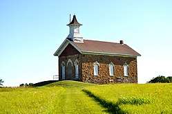 |
July 3, 2012 (#12000387) |
S. Arvonia Rd. 38°28′42″N 95°52′15″W / 38.4783°N 95.8708°W |
Lebo | One of Kansas' earliest architect-designed schools, built in 1872. |
| 2 | Arvonia Township Hall | January 11, 2017 (#100000516) |
S. Arvonia Rd. 38°28′49″N 95°52′10″W / 38.480256°N 95.869463°W |
Lebo | ||
| 3 | Atchison, Topeka, and Santa Fe Pratt Truss Bridge | May 9, 2003 (#03000364) |
SE Pine St., 0.1 miles (0.16 km) south of intersection with E. Emporia St. 38°30′19″N 95°38′07″W / 38.505278°N 95.635278°W |
Melvern | ||
| 4 | Banner Hereford Farm | June 12, 1998 (#98000659) |
19355 S. Berryton Rd. 38°42′56″N 95°38′31″W / 38.715556°N 95.641944°W |
Scranton | ||
| 5 | Calvinistic Methodist Church | July 3, 2012 (#12000388) |
8090 W. 9th St. 38°28′45″N 95°52′12″W / 38.479243°N 95.870059°W |
Lebo | ||
| 6 | Cow-Killer Archeological Site | June 24, 1975 (#75000719) |
Address restricted |
Melvern | ||
| 7 | Samuel Hunt Grave | May 11, 1995 (#95000586) |
K-31, east of crossing of Interstate 335 (the Kansas Turnpike) 38°45′15″N 95°55′32″W / 38.754167°N 95.925556°W |
Burlingame Township | ||
| 8 | Karnes Stone Barn | January 21, 2004 (#03001468) |
4204 E. 129th St. 38°50′02″N 95°35′30″W / 38.833889°N 95.591667°W |
Carbondale | ||
| 9 | Lyndon Carnegie Library | 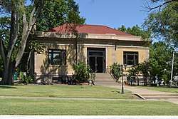 |
June 25, 1987 (#87000965) |
127 E. 6th 38°36′27″N 95°40′58″W / 38.6075°N 95.682778°W |
Lyndon | |
| 10 | Osage City Santa Fe Depot | 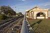 |
May 11, 1989 (#89000386) |
508 Market 38°38′11″N 95°49′38″W / 38.636389°N 95.827222°W |
Osage City | |
| 11 | Osage County Courthouse | 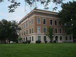 |
April 18, 2007 (#07000320) |
717 Topeka Ave. 38°36′37″N 95°41′00″W / 38.610278°N 95.683333°W |
Lyndon | |
| 12 | Rapp School District No. 50 | 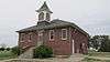 |
July 28, 1995 (#95000944) |
U.S. Route 56, northwest of Osage City 38°39′07″N 95°54′46″W / 38.651944°N 95.912778°W |
Osage City | |
| 13 | Schuyler Grade School | April 15, 2011 (#11000193) |
117 S. Dacotah St. 38°45′12″N 95°50′13″W / 38.753333°N 95.836944°W |
Burlingame |
See also
| Wikimedia Commons has media related to National Register of Historic Places in Osage County, Kansas. |
References
- ↑ The latitude and longitude information provided in this table was derived originally from the National Register Information System, which has been found to be fairly accurate for about 99% of listings. For about 1% of NRIS original coordinates, experience has shown that one or both coordinates are typos or otherwise extremely far off; some corrections may have been made. A more subtle problem causes many locations to be off by up to 150 yards, depending on location in the country: most NRIS coordinates were derived from tracing out latitude and longitudes from USGS topographical quadrant maps created under the North American Datum of 1927, which differs from the current, highly accurate WGS84 GPS system used by most on-line maps. Chicago is about right, but NRIS longitudes in Washington are higher by about 4.5 seconds, and are lower by about 2.0 seconds in Maine. Latitudes differ by about 1.0 second in Florida. Some locations in this table may have been corrected to current GPS standards.
- ↑ "National Register of Historic Places: Weekly List Actions". National Park Service, United States Department of the Interior. Retrieved on October 4, 2018.
- ↑ Numbers represent an ordering by significant words. Various colorings, defined here, differentiate National Historic Landmarks and historic districts from other NRHP buildings, structures, sites or objects.
- ↑ National Park Service (2009-03-13). "National Register Information System". National Register of Historic Places. National Park Service.
- ↑ The eight-digit number below each date is the number assigned to each location in the National Register Information System database, which can be viewed by clicking the number.


Municipalities and communities of Osage County, Kansas, United States | ||
|---|---|---|
| Cities | | |
| CDP | ||
| Unincorporated communities | ||
| Townships |
| |
This article is issued from
Wikipedia.
The text is licensed under Creative Commons - Attribution - Sharealike.
Additional terms may apply for the media files.