National Register of Historic Places listings in Barton County, Kansas
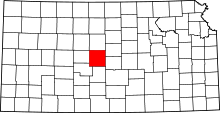
Location of Barton County in Kansas
This is a list of the National Register of Historic Places listings in Barton County, Kansas.
This is intended to be a complete list of the properties on the National Register of Historic Places in Barton County, Kansas, United States. The locations of National Register properties for which the latitude and longitude coordinates are included below, may be seen in a map.[1]
There are 18 properties listed on the National Register in the county. Three properties were once listed, but have since been removed.
- This National Park Service list is complete through NPS recent listings posted October 4, 2018.[2]
Current listings
| [3] | Name on the Register[4] | Image | Date listed[5] | Location | City or town | Description |
|---|---|---|---|---|---|---|
| 1 | Abel House | March 2, 2001 (#01000180) |
2601 Passeo 38°22′39″N 98°46′21″W / 38.3775°N 98.7725°W |
Great Bend | ||
| 2 | A.S. Allen Buildings | January 5, 2018 (#100001944) |
1401 Main St. & 2006 Forest 38°21′56″N 98°45′55″W / 38.365556°N 98.765146°W |
Great Bend | ||
| 3 | Beaver Creek Native Stone Bridge | 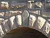 |
April 16, 2008 (#08000296) |
NE. 50 Ave. S. and NE 230 Rd. 38°41′42″N 98°40′58″W / 38.694891°N 98.682733°W |
Beaver | |
| 4 | Bridge No. 218-Off System Bridge | April 16, 2008 (#08000297) |
NE. 60 Ave. S. and NE. 220 Rd. 38°40′53″N 98°39′59″W / 38.681429°N 98.666320°W |
Beaver | ||
| 5 | Bridge No. 222-Off System Bridge | 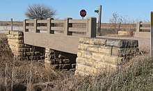 |
July 2, 2008 (#08000608) |
NE. 60 Ave., S. and NE. 210 Rd., 1/8 mile east on 210 Rd. 38°40′01″N 98°39′50″W / 38.666916°N 98.663803°W |
Beaver | |
| 6 | Bridge No. 640-Federal Aid Highway System Bridge |  |
July 2, 2008 (#08000611) |
NE 60 Ave., 1/8 mile north of NE 210 Rd. 38°40′03″N 98°39′51″W / 38.667462°N 98.664105°W |
Beaver | |
| 7 | Crest Theater | 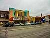 |
February 9, 2005 (#05000003) |
1905 Lakin Ave. 38°21′59″N 98°45′50″W / 38.366389°N 98.763889°W |
Great Bend | |
| 8 | Great Bend Army Air Field Hangar | October 5, 2015 (#15000686) |
9047 6th St. 38°20′50″N 98°51′12″W / 38.347250°N 98.853342°W |
Great Bend | ||
| 9 | Hoisington High School | November 15, 2005 (#05001248) |
218 E. 7th St. 38°31′13″N 98°46′34″W / 38.520326°N 98.776184°W |
Hoisington | ||
| 10 | Manweiler-Maupin Chevrolet | October 9, 2012 (#12000842) |
271 S. Main St. 38°30′43″N 98°46′40″W / 38.511866°N 98.777865°W |
Hoisington | Part of the Roadside Kansas MPS | |
| 11 | Nagel House | 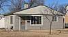 |
March 2, 2001 (#01000181) |
1411 Wilson St. 38°21′58″N 98°47′44″W / 38.366035°N 98.795459°W |
Great Bend | |
| 12 | Norden Bombsight Storage Vaults | October 5, 2015 (#15000687) |
9047 6th St. 38°20′48″N 98°51′10″W / 38.346549°N 98.852837°W |
Great Bend | ||
| 13 | Pawnee Rock | 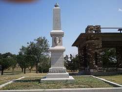 |
December 29, 1970 (#70000247) |
0.2 miles north of Pawnee Rock off U.S. 56 38°16′20″N 98°58′53″W / 38.272222°N 98.981389°W |
Pawnee Rock | |
| 14 | US Post Office-Hoisington | 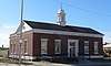 |
October 17, 1989 (#89001642) |
121 E. 2nd St. 38°30′53″N 98°46′35″W / 38.514653°N 98.776419°W |
Hoisington | |
| 15 | Walnut Creek Bridge | January 4, 1990 (#89002178) |
Over Walnut Creek, northwest of Heizer 38°25′54″N 98°53′40″W / 38.431667°N 98.894444°W |
Heizer | ||
| 16 | Walnut Creek Crossing | April 26, 1972 (#72000488) |
Along Walnut Creek above its confluence with the Arkansas River, east of Great Bend[6] 38°21′28″N 98°42′07″W / 38.3578°N 98.7019°W |
Great Bend Township | ||
| 17 | Wolf Hotel | November 7, 2002 (#02001295) |
104 E. Santa Fe 38°21′13″N 98°34′50″W / 38.353611°N 98.580556°W |
Ellinwood | ||
| 18 | Wolf Park Band Shell | August 4, 2003 (#03000706) |
Lots 12 and 13, Block 2, 200 block of N. Main 38°21′23″N 98°34′49″W / 38.356389°N 98.580278°W |
Ellinwood |
Former listings
| [3] | Name on the Register | Image | Date listed | Date removed | Location | City or town | Summary |
|---|---|---|---|---|---|---|---|
| 1 | Bridge No. 650-Federal Aid Highway System Bridge | July 2, 2008 (#08000612) | March 26, 2018 | NE 60 Ave., 1/12 mile south of NE 220 Rd. 38°40′52″N 98°39′51″W / 38.681086°N 98.664264°W |
Beaver | Apparently no longer extant[7] | |
| 2 | Hitschmann Cattle Underpass Bridge | April 16, 2008 (#08000298) | July 7, 2015 | NE. 110 Ave. S. & NE. 190 Rd. 38°38′16″N 98°34′20″W / 38.637778°N 98.572222°W |
Hitschmann | ||
| 3 | Hitschmann Double Arch Bridge | April 16, 2008 (#08000299) | July 7, 2015 | NE. 110 Ave. S. & NE. 190 Rd. 38°38′16″N 98°34′20″W / 38.637778°N 98.572222°W |
Hitschmann |
See also
| Wikimedia Commons has media related to National Register of Historic Places in Barton County, Kansas. |
References
- ↑ The latitude and longitude information provided in this table was derived originally from the National Register Information System, which has been found to be fairly accurate for about 99% of listings. For about 1% of NRIS original coordinates, experience has shown that one or both coordinates are typos or otherwise extremely far off; some corrections may have been made. A more subtle problem causes many locations to be off by up to 150 yards, depending on location in the country: most NRIS coordinates were derived from tracing out latitude and longitudes from USGS topographical quadrant maps created under the North American Datum of 1927, which differs from the current, highly accurate WGS84 GPS system used by most on-line maps. Chicago is about right, but NRIS longitudes in Washington are higher by about 4.5 seconds, and are lower by about 2.0 seconds in Maine. Latitudes differ by about 1.0 second in Florida. Some locations in this table may have been corrected to current GPS standards.
- ↑ "National Register of Historic Places: Weekly List Actions". National Park Service, United States Department of the Interior. Retrieved on October 4, 2018.
- 1 2 Numbers represent an ordering by significant words. Various colorings, defined here, differentiate National Historic Landmarks and historic districts from other NRHP buildings, structures, sites or objects.
- ↑ National Park Service (2009-03-13). "National Register Information System". National Register of Historic Places. National Park Service.
- ↑ The eight-digit number below each date is the number assigned to each location in the National Register Information System database, which can be viewed by clicking the number.
- ↑ Location derived from its NRHP nomination form; the NRIS lists the site as "Address Restricted"
- ↑ See 2017 photos, showing a concrete box at this location.


Municipalities and communities of Barton County, Kansas, United States | ||
|---|---|---|
| Cities | | |
| CDPs | ||
| Unincorporated communities | ||
| Townships | ||
| Footnotes | ‡This populated place also has portions in an adjacent county or counties | |
This article is issued from
Wikipedia.
The text is licensed under Creative Commons - Attribution - Sharealike.
Additional terms may apply for the media files.