National Register of Historic Places listings in Russell County, Kansas
Location of Russell County in Kansas
This is a list of the National Register of Historic Places listings in Russell County, Kansas.
This is intended to be a complete list of the properties on the National Register of Historic Places in Russell County, Kansas, United States. The locations of National Register properties for which the latitude and longitude coordinates are included below, may be seen in a map.[1]
There are 20 properties listed on the National Register in the county.
- This National Park Service list is complete through NPS recent listings posted October 4, 2018.[2]
Current listings
| [3] | Name on the Register[4] | Image | Date listed[5] | Location | City or town | Description |
|---|---|---|---|---|---|---|
| 1 | Archeological Site Number 14RU5 | July 9, 1982 (#82004867) |
Address restricted |
Russell | ||
| 2 | Archeological Site Number 14RU10 | July 9, 1982 (#82004868) |
Address restricted |
Dorrance | ||
| 3 | Archeological Site Number 14RU313 | July 9, 1982 (#82004869) |
Address restricted |
Russell | ||
| 4 | Archeological Site Number 14RU314 | July 9, 1982 (#82004870) |
Address restricted |
Paradise | ||
| 5 | Archeological Site Number 14RU315 | July 9, 1982 (#82004871) |
Address restricted |
Bunker Hill | ||
| 6 | Archeological Site Number 14RU316 | July 9, 1982 (#82004872) |
Address restricted |
Dorrance | ||
| 7 | Archeological Site Number 14RU324 | July 9, 1982 (#82004873) |
Address restricted |
Russell | ||
| 8 | Banks-Waudby Building | 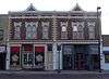 |
December 27, 2006 (#06001172) |
719 N. Main St. 38°53′33″N 98°51′34″W / 38.892576°N 98.85957°W |
Russell | |
| 9 | Deeble Rock Garden | October 4, 2017 (#100001705) |
126 Fairview Ave. 39°03′31″N 98°32′11″W / 39.058505°N 98.53652°W |
Lucas | ||
| 10 | Dorrance State Bank | 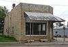 |
August 4, 2011 (#11000507) |
512 Main St. 38°50′45″N 98°35′20″W / 38.845729°N 98.588954°W |
Dorrance | |
| 11 | Dream Theater | _entrance_2.JPG) |
March 8, 2006 (#06000112) |
629 N. Main St. 38°53′30″N 98°51′34″W / 38.891797°N 98.859541°W |
Russell | |
| 12 | First National Bank-Waudby Building | 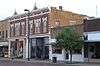 |
December 27, 2006 (#06001174) |
713 N. Main St. 38°53′33″N 98°51′34″W / 38.89251°N 98.859573°W |
Russell | |
| 13 | Garden of Eden | 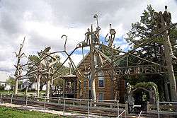 |
April 28, 1977 (#77000595) |
2nd and Kansas Ave. 39°03′33″N 98°32′04″W / 39.059167°N 98.534444°W |
Lucas | |
| 14 | Kennedy Hotel | _from_NW_1.JPG) |
January 17, 2007 (#06001244) |
117 Third St. 39°06′51″N 98°55′00″W / 39.114235°N 98.916646°W |
Paradise | |
| 15 | Mann House | March 2, 2001 (#01000190) |
614 Oakdale 38°53′04″N 98°51′08″W / 38.884413°N 98.852235°W |
Russell | 1949 Lustron dwelling with a Westchester Deluxe Plan.[6] | |
| 16 | Paradise Water Tower | 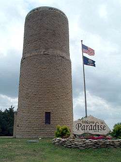 |
January 17, 2007 (#06001242) |
East of intersection of Waldo and Main Sts. 39°07′05″N 98°54′56″W / 39.118056°N 98.915556°W |
Paradise | |
| 17 | Reiff Building | _from_SE_2.JPG) |
March 15, 2007 (#07000140) |
513 Main St. 38°50′45″N 98°35′22″W / 38.845758°N 98.589421°W |
Dorrance | |
| 18 | Russell County Jail and Sheriff's Residence | 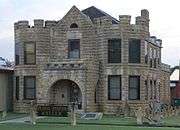 |
February 3, 2012 (#11001080) |
331 N. Kansas St. 38°53′20″N 98°51′30″W / 38.888962°N 98.858256°W |
Russell | |
| 19 | US Post Office-Russell | 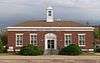 |
October 17, 1989 (#89001649) |
135 W. Sixth St. 38°53′29″N 98°51′39″W / 38.891384°N 98.860758°W |
Russell | |
| 20 | Woelk House | March 2, 2001 (#01000191) |
615 Sunset 38°53′02″N 98°51′07″W / 38.883924°N 98.85204°W |
Russell | 1949 Lustron dwelling with a Westchester Deluxe Plan.[7] |
See also
| Wikimedia Commons has media related to National Register of Historic Places in Russell County, Kansas. |
References
- ↑ The latitude and longitude information provided in this table was derived originally from the National Register Information System, which has been found to be fairly accurate for about 99% of listings. For about 1% of NRIS original coordinates, experience has shown that one or both coordinates are typos or otherwise extremely far off; some corrections may have been made. A more subtle problem causes many locations to be off by up to 150 yards, depending on location in the country: most NRIS coordinates were derived from tracing out latitude and longitudes from USGS topographical quadrant maps created under the North American Datum of 1927, which differs from the current, highly accurate WGS84 GPS system used by most on-line maps. Chicago is about right, but NRIS longitudes in Washington are higher by about 4.5 seconds, and are lower by about 2.0 seconds in Maine. Latitudes differ by about 1.0 second in Florida. Some locations in this table may have been corrected to current GPS standards.
- ↑ "National Register of Historic Places: Weekly List Actions". National Park Service, United States Department of the Interior. Retrieved on October 4, 2018.
- ↑ Numbers represent an ordering by significant words. Various colorings, defined here, differentiate National Historic Landmarks and historic districts from other NRHP buildings, structures, sites or objects.
- ↑ National Park Service (2008-04-24). "National Register Information System". National Register of Historic Places. National Park Service.
- ↑ The eight-digit number below each date is the number assigned to each location in the National Register Information System database, which can be viewed by clicking the number.
- ↑ "Mann Residence". nps.gov. Retrieved 25 September 2015.
- ↑ "Woelk House". nps.gov. Retrieved 25 September 2015.
| Topics | |
|---|---|
| Lists by states |
|
| Lists by insular areas | |
| Lists by associated states | |
| Other areas | |
| |
Municipalities and communities of Russell County, Kansas, United States | ||
|---|---|---|
| Cities | | |
| Unincorporated communities | ||
| Ghost towns | ||
| Townships | ||
| Footnotes | ‡This populated place also has portions in an adjacent county or counties | |
This article is issued from
Wikipedia.
The text is licensed under Creative Commons - Attribution - Sharealike.
Additional terms may apply for the media files.