Stafford, Kansas
| Stafford, Kansas | |
|---|---|
| City | |
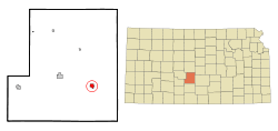 Location within Stafford County and Kansas | |
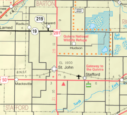 KDOT map of Stafford County (legend) | |
| Coordinates: 37°57′46″N 98°36′4″W / 37.96278°N 98.60111°WCoordinates: 37°57′46″N 98°36′4″W / 37.96278°N 98.60111°W | |
| Country | United States |
| State | Kansas |
| County | Stafford |
| Government | |
| • Type | Mayor–Council |
| Area[1] | |
| • Total | 0.92 sq mi (2.38 km2) |
| • Land | 0.92 sq mi (2.38 km2) |
| • Water | 0 sq mi (0 km2) |
| Elevation | 1,857 ft (566 m) |
| Population (2010)[2] | |
| • Total | 1,042 |
| • Estimate (2016)[3] | 978 |
| • Density | 1,100/sq mi (440/km2) |
| Time zone | UTC-6 (Central (CST)) |
| • Summer (DST) | UTC-5 (CDT) |
| ZIP code | 67578 |
| Area code | 620 |
| FIPS code | 20-67775 [4] |
| GNIS feature ID | 0473592 [5] |
| Website | cityofstaffordks.com |
Stafford is a city in Stafford County, Kansas, United States. As of the 2010 census, the city population was 1,042.[6]
History
Stafford was founded in 1878.[7] Like Stafford County, the city was named for Lewis Stafford, a casualty in the Civil War.[8] Stafford was destroyed by a tornado in 1882, and rebuilt within a year. Stafford was incorporated as a city in 1885.[9]
The city's railroad depot was built in 1911 and demolished in late 2016.[10]
Geography
Stafford is located at 37°57′46″N 98°36′4″W / 37.96278°N 98.60111°W (37.962789, -98.600996).[11] According to the United States Census Bureau, the city has a total area of 0.92 square miles (2.38 km2), all of it land.[1] It is approximately ninety-two miles northwest of Wichita on U.S. Route 50.
Demographics
| Historical population | |||
|---|---|---|---|
| Census | Pop. | %± | |
| 1890 | 640 | — | |
| 1900 | 1,068 | 66.9% | |
| 1910 | 1,927 | 80.4% | |
| 1920 | 1,752 | −9.1% | |
| 1930 | 1,614 | −7.9% | |
| 1940 | 2,011 | 24.6% | |
| 1950 | 2,005 | −0.3% | |
| 1960 | 1,862 | −7.1% | |
| 1970 | 1,414 | −24.1% | |
| 1980 | 1,425 | 0.8% | |
| 1990 | 1,344 | −5.7% | |
| 2000 | 1,161 | −13.6% | |
| 2010 | 1,042 | −10.2% | |
| Est. 2016 | 978 | [3] | −6.1% |
| U.S. Decennial Census | |||
2010 census
As of the census[2] of 2010, there were 1,042 people, 487 households, and 262 families residing in the city. The population density was 1,132.6 inhabitants per square mile (437.3/km2). There were 622 housing units at an average density of 676.1 per square mile (261.0/km2). The racial makeup of the city was 94.3% White, 0.8% African American, 1.7% Native American, 0.1% Asian, 1.5% from other races, and 1.5% from two or more races. Hispanic or Latino of any race were 5.9% of the population.
There were 487 households of which 23.4% had children under the age of 18 living with them, 41.9% were married couples living together, 7.4% had a female householder with no husband present, 4.5% had a male householder with no wife present, and 46.2% were non-families. 42.5% of all households were made up of individuals and 24.1% had someone living alone who was 65 years of age or older. The average household size was 2.04 and the average family size was 2.76.
The median age in the city was 48.2 years. 21.4% of residents were under the age of 18; 6% were between the ages of 18 and 24; 18.5% were from 25 to 44; 27.4% were from 45 to 64; and 26.8% were 65 years of age or older. The gender makeup of the city was 46.8% male and 53.2% female.
2000 census
As of the census[4] of 2000, there were 1,161 people, 525 households, and 305 families residing in the city. The population density was 1,234.3 people per square mile (476.9/km²). There were 640 housing units at an average density of 680.4 per square mile (262.9/km²). The racial makeup of the city was 95.95% White, 0.09% African American, 0.86% Native American, 1.46% from other races, and 1.64% from two or more races. Hispanic or Latino of any race were 3.53% of the population.
There were 525 households out of which 25.1% had children under the age of 18 living with them, 45.7% were married couples living together, 9.5% had a female householder with no husband present, and 41.9% were non-families. 39.4% of all households were made up of individuals and 24.4% had someone living alone who was 65 years of age or older. The average household size was 2.12 and the average family size was 2.83.
In the city, the population was spread out with 23.9% under the age of 18, 5.3% from 18 to 24, 20.4% from 25 to 44, 21.5% from 45 to 64, and 28.9% who were 65 years of age or older. The median age was 45 years. For every 100 females, there were 82.5 males. For every 100 females age 18 and over, there were 76.1 males.
The median income for a household in the city was $27,092, and the median income for a family was $32,383. Males had a median income of $26,307 versus $18,438 for females. The per capita income for the city was $16,032. About 11.2% of families and 16.4% of the population were below the poverty line, including 26.0% of those under age 18 and 9.6% of those age 65 or over.
Education
All students in Stafford attend school in the same building. The district is rated 1A by the state; consequently, its teams play eight-man football.
Notable people
- Neva Egan, American educator, former First Lady of Alaska (1959–1966, 1970–1974).
- Tony Fields, dancer, actor; Fields is best known in his tenure as a Solid Gold Dancer (1979-1984) and his film roles of Alan DeLuca in the 1985 movie version of A Chorus Line and Sammi Curr in the 1986 cult horror film Trick Or Treat.
Gallery
- Historic Images of Stafford, Special Photo Collections at Wichita State University Library
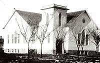 Stafford Reformed Presbyterian Church after its construction in 1913.
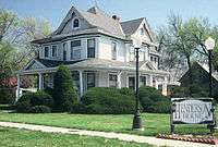 Sarah L. Henderson House (NRHP), 2009.
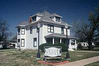 Joseph L. Spickard House, (NRHP), 2009.
See also
References
- 1 2 "US Gazetteer files 2010". United States Census Bureau. Archived from the original on 2012-01-24. Retrieved 2012-07-06.
- 1 2 "American FactFinder". United States Census Bureau. Retrieved 2012-07-06.
- 1 2 "Population and Housing Unit Estimates". Retrieved June 9, 2017.
- 1 2 "American FactFinder". United States Census Bureau. Retrieved 2008-01-31.
- ↑ "US Board on Geographic Names". United States Geological Survey. 2007-10-25. Retrieved 2008-01-31.
- ↑ "2010 City Population and Housing Occupancy Status". U.S. Census Bureau. Retrieved June 30, 2011.
- ↑ Kansas State Historical Society (1916). Biennial Report of the Board of Directors of the Kansas State Historical Society. Kansas State Printing Plant. p. 303.
- ↑ "Profile for Stafford, Kansas". ePodunk. Retrieved 23 June 2014.
- ↑ Blackmar, Frank Wilson (1912). Kansas: A Cyclopedia of State History, Volume 2. Standard Publishing Company. p. 734.
- ↑ Tanner, Beccy (November 16, 2016). "Relic of the past: Kansas' depots slowly fading away". The Wichita Eagle. Retrieved April 28, 2018.
- ↑ "US Gazetteer files: 2010, 2000, and 1990". United States Census Bureau. 2011-02-12. Retrieved 2011-04-23.
External links
| Wikimedia Commons has media related to Stafford, Kansas. |
- City
- Schools
- USD 349, local school district
- Historical
- The Glass Photographic Negatives of William Gray on YouTube, from Hatteberg's People on KAKE TV news
- Maps
- Stafford City Map, KDOT
Municipalities and communities of Stafford County, Kansas, United States | ||
|---|---|---|
| Cities | 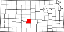 | |
| Unincorporated communities | ||