Montier, Missouri
| Montier, Missouri | |
|---|---|
| Census-designated place | |
 Montier Location within the state of Missouri | |
| Coordinates: 36°59′13″N 91°34′31″W / 36.98694°N 91.57528°WCoordinates: 36°59′13″N 91°34′31″W / 36.98694°N 91.57528°W | |
| Country | United States |
| State | Missouri |
| County | Shannon |
| Township | Montier |
| Elevation | 1,075 ft (328 m) |
| Population (2010) | |
| • Total | 98 |
| • Density | 66/sq mi (106.2/km2) |
| Time zone | UTC-6 (Central (CST)) |
| • Summer (DST) | UTC-5 (CDT) |
| ZIP code | 65546 |
| Area code(s) | 573 |
| FIPS code | 29-49610[1] |
| GNIS feature ID | 722548[2] |
Montier is a census-designated place in southwestern Shannon County, Missouri, United States.[3]
History
A variant name was "Monteer".[4] A post office called Monteer was established in 1889, and the spelling was changed to Montier in 1924.[5] The community has the name of A. N. Montier, a railroad official.[6]
Geography
Montier is located about seven miles east of Mountain View on U.S. Route 60.
References
- ↑ "American FactFinder". United States Census Bureau. Retrieved 2008-01-31.
- ↑ "US Board on Geographic Names". United States Geological Survey. 2007-10-25. Retrieved 2008-01-31.
- ↑ U.S. Geological Survey Geographic Names Information System: Montier Census Designated Place
- ↑ U.S. Geological Survey Geographic Names Information System: Montier
- ↑ "Post Offices". Jim Forte Postal History. Retrieved 25 December 2016.
- ↑ "Shannon County Place Names, 1928–1945". The State Historical Society of Missouri. Archived from the original on June 24, 2016. Retrieved December 25, 2016.
Municipalities and communities of Shannon County, Missouri, United States | ||
|---|---|---|
| Cities | 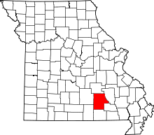 | |
| Townships | ||
| CDP | ||
| Unincorporated communities | ||
| Ghost towns | ||
| Footnotes | ‡This populated place also has portions in an adjacent county or counties | |
This article is issued from
Wikipedia.
The text is licensed under Creative Commons - Attribution - Sharealike.
Additional terms may apply for the media files.