James C. Nance Memorial Bridge
| James C. Nance Memorial Bridge | |
|---|---|
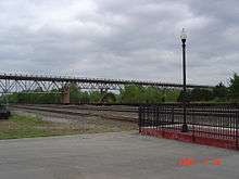 The Nance Bridge as seen from the Purcell train station. | |
| Coordinates |
35°0′51″N 97°21′10″W / 35.01417°N 97.35278°WCoordinates: 35°0′51″N 97°21′10″W / 35.01417°N 97.35278°W |
|
US Highway 77 Bridge at Canadian River | |
  | |
| Location |
|
| Coordinates | 35°0′54″N 97°20′38″W / 35.01500°N 97.34389°W |
| Area | 3.5 acres (1.4 ha) |
| Built | 1938 |
| Architectural style | Other, Deck Truss Bridge |
| NRHP reference # | 03000882[1] |
| Added to NRHP | September 2, 2003 |
| Carries |
2 lanes of |
| Crosses | Canadian River |
| Locale | Purcell-Lexington, Oklahoma |
| Maintained by | Oklahoma Department of Transportation |
| ID number | 06593 |
| Characteristics | |
| Design | Deck truss |
| Total length | 1,110.1 metres (3,642 ft)[2] |
| History | |
| Opened | 1938 |
The James C. Nance Memorial Bridge is a deck truss bridge crossing the Canadian River between Purcell and Lexington, Oklahoma. The bridge carries U.S. Route 77 (US-77) and Oklahoma State Highway 39 (SH-39) from McClain County to Cleveland County. The bridge is named for James C. Nance, longtime newspaper publisher and former member of the Oklahoma Legislature.
The Nance bridge allows travel time from Purcell (west side of the Canadian river) to Lexingon (East side of the river) to be only 3 minutes by car, according to google maps. When the bridge was closed (Emergency Closure, below), the same trip was 43 minutes when re-routed North to the nearest bridge, or 1 hour and 4 minutes when re-routed Southeast to the nearest bridge.
The 1938 construction of this bridge enabled communities from West and Southwest (Byars, Cole, Dibble, Paoli, Pauls Valley, Purcell, Rosedale, and Wayne) side of the river to reach the communities on the East side of the river (Lexington, Slaughterville, and Wanette). Traffic using the bridge allows trade and commerce to freely flow in this retail trade area of southern McClain County, southern Cleveland County, Southern Pottawatomie County, and northern area of Garvin County, and eastern portion of Grady county.
Emergency Closure
On January 31, 2014, the Oklahoma Department of Transportation closed the bridge temporarily until discovered major structural damage and deficiencies due to aging and cracking of the truss system could be evaluated and repaired. The bridge was reopened June 13, 2014, to lighter vehicles once sufficient repairs were made (load limit for trucks); Bridge replacement was estimated to exceed $43 million.[3]
The Oklahoma Transportation Commission awarded a contract on September 5, 2017, to construct a new bridge costing $36 million. Officials say half of the new bridge will be built alongside the existing structure. Then, the old bridge will be removed to make room for the new, four-lane bridge crossing the South Canadian River. Construction is expected to last two years. The contract awarded Tuesday includes $2 million in possible financial incentives if the project is finished early.[4]
A rendering of the new bridge design can be seen on the Oklahoma Department of Transportation (ODOT) website, as well as a photo from the Oklahoma Historical Society of Nance Bridge's opening in 1938: https://www.ok.gov/odot/Purcell_Lexington_Bridge_project.html.
The closure caused substantial economic disruption to the City of Purcell, as the bridge delivers thousands a vehicles a day from southern Cleveland county and points east to Interstate 35 (through Purcell), the major north-south interstate corridor in Oklahoma. Local residents in Lexington and southern Cleveland county could no longer conduct commerce in Purcell, and travelers from points east still passed through Lexington, but instead had to turn north for an additional 15-mile journey through rural Cleveland county to the next available access to Interstate 35 on the south side of Norman.[5]
Municipal Water Source
In 1982, the James C. Nance bridge was structurally reinforced and a large elevated pipeline was attached underneath to carry the bulk of Purcell's water supply which comes from deep water wells that tap into an aquifer east of Lexington.
Historical Notes
The Nance bridge is 1,110.1 meters[2] (3,642 ft) long, making it among the longest in the state.[6]
The bridge was listed in the National Register of Historic Places on 2003-09-02.[2][1]
See also


References
- Oklahoma Highway Department
- State of Oklahoma
- Footnotes
- 1 2 National Park Service (2010-07-09). "National Register Information System". National Register of Historic Places. National Park Service.
- 1 2 3 National Bridge Inventory
- ↑ "Oklahoma Department of Transportation - Purcell/LexingtonBridge". www.ok.gov. Retrieved 2017-09-25.
- ↑ http://okcfox.com/news/local/highway-officials-award-contract-for-new-purcell-lexington-bridge
- ↑ "Bridge connecting Lexington to Purcell closed for all drivers", KOKH-TV, January 31, 2014.
- ↑ Kinsler, Wes. . Oklahoma Bridges. URL accessed 20 January 2008.
Crossings of the Canadian River | ||||
|---|---|---|---|---|
| ||||
| Moore |
| |
|---|---|---|
| Newalla |
| |
| Norman |
| |
| Purcell | ||
| Stella | ||