Eureka Township, Barton County, Kansas
| Eureka Township | |
|---|---|
| Township | |
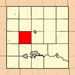 Location in Barton County | |
| Coordinates: 38°28′40″N 098°52′01″W / 38.47778°N 98.86694°WCoordinates: 38°28′40″N 098°52′01″W / 38.47778°N 98.86694°W | |
| Country | United States |
| State | Kansas |
| County | Barton |
| Area | |
| • Total | 36.1 sq mi (93.49 km2) |
| • Land | 36.01 sq mi (93.27 km2) |
| • Water | 0.09 sq mi (0.22 km2) 0.24% |
| Elevation | 1,923 ft (586 m) |
| Population (2010) | |
| • Total | 82 |
| • Density | 2.3/sq mi (0.88/km2) |
| GNIS feature ID | 0475642 |
Eureka Township is a township in Barton County, Kansas, USA. As of the 2010 census, its population was 82.[1]
Eureka Township was organized in 1878.[2]
Geography
Eureka Township covers an area of 36.1 square miles (93 km2) and contains no incorporated settlements. According to the USGS, it contains one cemetery, Walnut Valley.
References
- ↑ "Profile of General Population and Housing Characteristics: 2010 Demographic Profile Data (DP-1): Eureka township, Barton County, Kansas". U.S. Census Bureau, American Factfinder. Archived from the original on September 11, 2013. Retrieved July 12, 2012.
- ↑ History of the State of Kansas: Containing a Full Account of Its Growth from an Uninhabited Territory to a Wealthy and Important State. A. T. Andreas. 1883. p. 762.
External links
Municipalities and communities of Barton County, Kansas, United States | ||
|---|---|---|
| Cities | 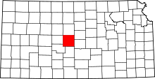 | |
| CDPs | ||
| Unincorporated communities | ||
| Townships | ||
| Footnotes | ‡This populated place also has portions in an adjacent county or counties | |
This article is issued from
Wikipedia.
The text is licensed under Creative Commons - Attribution - Sharealike.
Additional terms may apply for the media files.