South Homestead Township, Barton County, Kansas
| South Homestead Township | |
|---|---|
| Township | |
 Location in Barton County | |
| Coordinates: 38°28′42″N 098°45′23″W / 38.47833°N 98.75639°WCoordinates: 38°28′42″N 098°45′23″W / 38.47833°N 98.75639°W | |
| Country | United States |
| State | Kansas |
| County | Barton |
| Area | |
| • Total | 35.06 sq mi (90.81 km2) |
| • Land | 34.63 sq mi (89.69 km2) |
| • Water | 0.43 sq mi (1.12 km2) 1.23% |
| Elevation | 1,808 ft (551 m) |
| Population (2010) | |
| • Total | 322 |
| • Density | 9.2/sq mi (3.5/km2) |
| GNIS feature ID | 0475510 |
South Homestead Township is a township in Barton County, Kansas, United States. As of the 2010 census, its population was 322.[1]
Geography
South Homestead Township covers an area of 35.06 square miles (90.8 km2). The incorporated city of Hoisington sits on the township's northern border with North Homestead Township. According to the USGS, it contains two cemeteries: Hillcrest Memorial Park and Saint John.
The stream of Deception Creek runs through this township.
References
- ↑ "Profile of General Population and Housing Characteristics: 2010 Demographic Profile Data (DP-1): South Homestead township, Barton County, Kansas". U.S. Census Bureau, American Factfinder. Retrieved July 13, 2012.
External links
Municipalities and communities of Barton County, Kansas, United States | ||
|---|---|---|
| Cities | 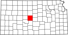 | |
| CDPs | ||
| Unincorporated communities | ||
| Townships | ||
| Footnotes | ‡This populated place also has portions in an adjacent county or counties | |
This article is issued from
Wikipedia.
The text is licensed under Creative Commons - Attribution - Sharealike.
Additional terms may apply for the media files.