Nantun District
Coordinates: 24°8′29.7″N 120°38′15.8″E / 24.141583°N 120.637722°E
| Nantun District 南屯區 | |
|---|---|
| District | |
 | |
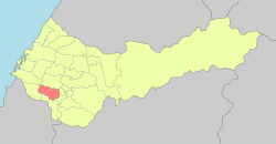 Nantun District in Taichung City | |
| Location | Taichung, Taiwan |
| Area | |
| • Total | 31 km2 (12 sq mi) |
| Population (July 2018) | |
| • Total | 169,707 |
| • Density | 5,500/km2 (14,000/sq mi) |
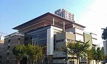
Nantun District Office
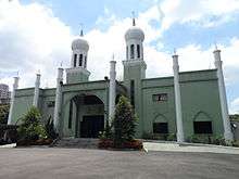
Taichung Mosque
Nantun District (Chinese: 南屯區; pinyin: Nántún Qū) is an urban district in Taichung, Taiwan. It was a part of Taichung before the City and County were amalgamated in 2010.
History
The district used to be part of Taichung provincial city before the merger with Taichung County to form Taichung special municipality on 25 December 2010.
Administrative divisions
Nantun, Fengle, Fengshu, Zhonghe, Zengping, Chunshe, Chunan, Wenshan, Baoshan, Xinsheng, Yongding, Sancuo, Sanyi, Sanhe, Liming, Gouqi, Daye, Huizhong, Tianxin, Xiangxin, Wenxin, Tongxin, Datong, Daxing and Dacheng Village.[1]
Government institutions
Education
Tourist attractions
See also
| Wikimedia Commons has media related to Nantun District, Taichung. |
References
External links
- Nantun District Government Office (in Chinese)
City seat: Xitun | ||
| Urban area | .svg.png) | |
| Coastal area | ||
| Highland area | ||
| Mountain indigenous district | ||
Note: Although Hanyu Pinyin is the national standard; Central, East, South, West, and North District uses English instead. | ||
This article is issued from
Wikipedia.
The text is licensed under Creative Commons - Attribution - Sharealike.
Additional terms may apply for the media files.