Mukteshwar
| Mukteshwar | |
|---|---|
| city | |
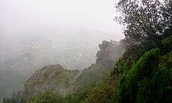 view of Chauli ki jali at Mukteshwar | |
 Mukteshwar Location in Uttarakhand, India  Mukteshwar Mukteshwar (India) | |
| Coordinates: 29°28′20″N 79°38′52″E / 29.4722°N 79.6479°ECoordinates: 29°28′20″N 79°38′52″E / 29.4722°N 79.6479°E | |
| Country |
|
| State | Uttarakhand |
| District | Nainital |
| Elevation | 2,171 m (7,123 ft) |
| Languages | |
| • Official | Hindi |
| Time zone | UTC+5:30 (IST) |
| PIN | 263138 |
| Telephone code | 05942 |
| Vehicle registration | UK |
| Website |
uk |
Mukteshwar is a town and tourist destination in the Nainital district of Uttarakhand, India. It sits high in the Kumaon Hills at an altitude of 2286[1] meters (7500 feet), 51 km from Nainital, 72 km from Haldwani, and 343 km from Delhi.
Local attractions
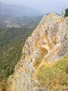
Mukteshwar gets its name from a 350-year-old temple of Shiva, known as Mukteshwar Dham, situated atop the highest point in the town, on the veterinary institute's campus. Close to it lie the overhanging cliffs, locally known as Chauli-ki-Jali, used for rock climbing and rappelling, with an excellent view of the valleys below. The sunrise point is at the government-run PWD guest house. One can also visit the Indian Veterinary Research Institute (IVRI). Mukteshwar is the abode of a saint — Shri Mukteshwar Maharaj ji — who lived at the Top Cottage Temple where his samadhi is. One of his disciples, Swami Sanshudhanand ji, now stays there. The whole temple complex is a Tapovan and an ideal place for meditation. Mukteshwar temple was built by a pandiya king from the Tamil kingdom during the 15th century. This can be confirmed by local guides who have been living there for generations.
The major attractions of this sleepy town are the IVRI laboratories (experiments on tiny rats, gold-plated books, cattle-sheds), orchards of the Central Institutes of Temperate Horticulture-Regional Station, an expansive deodar forest (Himalayan cedar) measuring 15 square miles, 22 pristine snow-peak views, and the adventure of living among wildlife such as tigers and bears are. The charm of visiting Mukteshwar lies in enjoying nature, listening to air gushing through deodar forests, bird watching, meditation, and seeking peace. The cleanliness, solitude and nature attract people escaping urban life.
Mukteshwar is also home to a post office founded in 1905 which finds mention in Jim Corbett's writing.
History

Mukteshwar was previously Muktesar (as mentioned in Jim Corbett's book "The Temple Tiger"); the name changed after 1947. Until 1893 the place was known for its shrines and temple before it was selected for serum production to protect animals from cattle plague.[2] On the recommendation of the Cattle Plague Commission, the Imperial Bacteriological Laboratory had its genesis on 9 December 1889 at Pune and relocated to Mukteshwar in 1893[3] to facilitate segregation and quarantine of highly contagious organisms. Initially the laboratory at Mukteshwar was completed in 1898 but destroyed by fire in 1899. It was resurrected in 1901. Then annual expenditure on research was Rs. 50,000.[2] Later it was developed into the Indian Veterinary Research Institute (IVRI), which later moved its headquarters to Izatnagar. Still Mukteshwar serves as the hill campus of IVRI, including facilities such as an experimental goat farm.[4][5]
The noted Nobel winner scientist Robert Koch visited this place on request of the government of India. The microscope used by him and other historical articles are kept in the museum maintained by IVRI. An hill carved cold room dating back to 1900 once used to store biological materials is now a tourist attraction.
Famous saviour of horror-stricken people from man-eating tigers and writer Jim Corbett visited Mukteshwar. He wrote of Mukteshwar in Man-Eaters of Kumaon.[6] Corbett wrote befitting and thrilling accounts of his experiences in the jungle. His books can be freely downloaded online.[6][7][8][9]
Geography

| Mukteshwar | ||||||||||||||||||||||||||||||||||||||||||||||||||||||||||||
|---|---|---|---|---|---|---|---|---|---|---|---|---|---|---|---|---|---|---|---|---|---|---|---|---|---|---|---|---|---|---|---|---|---|---|---|---|---|---|---|---|---|---|---|---|---|---|---|---|---|---|---|---|---|---|---|---|---|---|---|---|
| Climate chart (explanation) | ||||||||||||||||||||||||||||||||||||||||||||||||||||||||||||
| ||||||||||||||||||||||||||||||||||||||||||||||||||||||||||||
| ||||||||||||||||||||||||||||||||||||||||||||||||||||||||||||
Mukteshwar is located at 29°28′20″N 79°38′52″E / 29.4722°N 79.6479°E.[11] It has an average elevation of 2,286 metres (7,500 feet). Mukteshwar is situated in Nainital district at a distance of 51 km from Nainital, the district's administrative headquarter and 72 km from Haldwani, the largest city in Nainital.
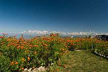
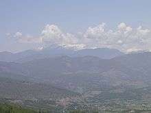
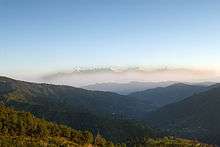
Mukteshwar is rich in scenic beauty, with magnificent views of the Indian Himalayas including India's second-highest peak, Nanda Devi. Because of the hilly topography, agriculture in the area consists chiefly of potato fields and fruit orchards on terraces cut into the hillsides.
Climate

Mukteshwar has a subtropical highland climate (Köppen climate classification Cwb). The pattern of seasons is similar to that in other parts of northern India, with distinct summer, monsoon and winter seasons. However, due to its high elevation, Mukteshwar is spared the intense heat of lower-lying towns and cities. Mukteshwar has cold winters and relatively cool summer with drastically escalated rain, in relation with lower altitudes, and frequent fog. Summers are warm with moderate rainfall, while the monsoon season is slightly cooler and features much heavier rain. Winters can be quite cool, and temperatures below freezing are not unusual. Snowfall occurs occasionally in December and January, though it is sparse, while the heavy rainfall events occurs during the monsoon season stretching from July to September.
| Climate data for Mukteshwar | |||||||||||||
|---|---|---|---|---|---|---|---|---|---|---|---|---|---|
| Month | Jan | Feb | Mar | Apr | May | Jun | Jul | Aug | Sep | Oct | Nov | Dec | Year |
| Record high °C (°F) | 22.8 (73) |
24.0 (75.2) |
26.8 (80.2) |
27.6 (81.7) |
30.3 (86.5) |
30.2 (86.4) |
30.3 (86.5) |
29.0 (84.2) |
26.3 (79.3) |
25.3 (77.5) |
22.4 (72.3) |
22.3 (72.1) |
30.3 (86.5) |
| Average high °C (°F) | 11.6 (52.9) |
12.3 (54.1) |
16.6 (61.9) |
21.5 (70.7) |
23.7 (74.7) |
23.4 (74.1) |
21.1 (70) |
20.5 (68.9) |
20.5 (68.9) |
19.9 (67.8) |
17.0 (62.6) |
13.9 (57) |
18.5 (65.3) |
| Daily mean °C (°F) | 6.4 (43.5) |
7.1 (44.8) |
10.9 (51.6) |
15.4 (59.7) |
17.7 (63.9) |
18.3 (64.9) |
17.2 (63) |
16.9 (62.4) |
16.1 (61) |
14.3 (57.7) |
11.2 (52.2) |
8.4 (47.1) |
13.3 (56) |
| Average low °C (°F) | 1.1 (34) |
1.7 (35.1) |
5.1 (41.2) |
9.3 (48.7) |
11.7 (53.1) |
13.1 (55.6) |
13.4 (56.1) |
13.2 (55.8) |
11.6 (52.9) |
8.8 (47.8) |
5.3 (41.5) |
2.9 (37.2) |
8.1 (46.6) |
| Record low °C (°F) | −6.9 (19.6) |
−6.6 (20.1) |
−6.1 (21) |
0.0 (32) |
2.5 (36.5) |
6.9 (44.4) |
4.4 (39.9) |
9.8 (49.6) |
5.9 (42.6) |
2.5 (36.5) |
−1.4 (29.5) |
−4.1 (24.6) |
−6.9 (19.6) |
| Average precipitation mm (inches) | 44 (1.73) |
57 (2.24) |
66 (2.6) |
40 (1.57) |
70 (2.76) |
151 (5.94) |
313 (12.32) |
281 (11.06) |
197 (7.76) |
43 (1.69) |
10 (0.39) |
29 (1.14) |
1,301 (51.2) |
| Average precipitation days | 4.4 | 5.6 | 6.0 | 4.4 | 7.5 | 11.4 | 18.6 | 18.7 | 12.3 | 3.3 | 0.9 | 2.5 | 95.6 |
| Average relative humidity (%) | 60 | 59 | 54 | 46 | 52 | 72 | 91 | 93 | 85 | 68 | 59 | 52 | 66 |
| Source: NOAA (1971-1990) [12] | |||||||||||||
Kumaon Vani radio service

With the aim to create a common platform for local communities of Supi in Uttarakhand, TERI launched 'Kumaon Vani', a community radio service on 11 March 2010. Uttarakhand governor Margaret Alva inaugurated the radio station, the first in the state. The 'Kumaon Vani' aims to air programmes on environment, agriculture, culture, weather and education in the local language and with the active participation of the communities. The station covers a radius of 10 km reaching out to almost 2000 locals around Mukteshwar.[13]
New development

There is a 'Renewable Park' developed by TERI. The renewable park uses solar electricity for most of its electricity needs. Recently, the town has experienced some construction activity and townships have begun to mushroom in and around Mukteshwar. Many people are buying holiday homes here to escape large chaotic cities.
Transport
The nearest airport is at Pantnagar and the nearest railway head is at Kathgodam, 65 km from the town, from where vehicular transport is easily available from neighbouring towns of Bhimtal, Bhowali, and Nainital.
The other means of road transport in the city include Share taxis, regionally known as Jeeps, on-call metered taxis and tourist taxis.
References
- ↑ "NAINITAL TOURISM 1000 Pages Since 1999 - Mukteshwar | Mukteshwar Tourism | Mukteshwar Temple | Mukteshwar Travel Guide | Mukteshwar Nainital India | Camping In Mukteshwar | How To Reach Mukteshwar | Mukteshwar Weather | Mukteshwar Distance Chart". www.highwaymonks.com. Retrieved 2016-01-27.
- 1 2 Imperial Gazetteer of India, Volume 18, Page 18
- ↑ Mukteshwar Archived 2008-06-21 at the Wayback Machine. Official website of Nainital district
- ↑ Evolution of IVRI Archived 2009-02-08 at the Wayback Machine. Indian Veterinary Research Institute Official website.
- ↑ Campuses Archived 2009-02-01 at the Wayback Machine., Indian Veterinary Research Institute official website.
- 1 2 https://archive.org/details/TheTempleTigerAndMoreMan-eatersOfKumaon1954
- ↑ https://archive.org/details/maneatersofkumao029903mbp
- ↑ https://archive.org/details/JungleLore
- ↑ https://archive.org/details/TheMan-eatingLeopardOfRudraprayag1947
- ↑ "World Weather Information Service". worldweather.wmo.int. Retrieved 16 November 2016.
- ↑ Falling Rain Genomics, Inc - Mukteshwar
- ↑ "Mukteswar/Kumaon Climate Normals 1971-1990". National Oceanic and Atmospheric Administration. Retrieved 21 December 2012.
- ↑ http://news.oneindia.in/2010/03/13/terilaunches-kumaon-vani-community-radio-service.html
External links
| Wikimedia Commons has media related to Mukteshwar. |

- Mukteshwar Hotels
- Budget Nature Resort in Mukteshwar