Alewife station
ALEWIFE | |||||||||||
|---|---|---|---|---|---|---|---|---|---|---|---|
 A Red Line train at Alewife in April 2006 | |||||||||||
| Location |
11 Cambridgepark West Cambridge, Massachusetts | ||||||||||
| Coordinates | 42°23′47″N 71°08′31″W / 42.3964°N 71.142°WCoordinates: 42°23′47″N 71°08′31″W / 42.3964°N 71.142°W | ||||||||||
| Owned by | Massachusetts Bay Transportation Authority | ||||||||||
| Line(s) | |||||||||||
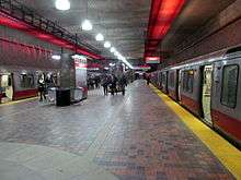
| Platforms | 1 island platform | ||||||||||
| Tracks | 2 | ||||||||||
| Connections |
| ||||||||||
| Construction | |||||||||||
| Parking | 2,733 spaces in garage | ||||||||||
| Bicycle facilities | ~500 spaces in three secured cages | ||||||||||
| Disabled access | Yes | ||||||||||
| History | |||||||||||
| Opened | March 30, 1985[1] | ||||||||||
| Traffic | |||||||||||
| Passengers (2013) | 11,221 (weekday average boardings)[2] | ||||||||||
| Services | |||||||||||
| |||||||||||
Alewife is an intermodal transit station in Cambridge, Massachusetts. It serves the MBTA's Red Line subway system and is an MBTA Bus hub. Alewife is the northern terminus of the Red Line. Alewife station is located in the North Cambridge neighborhood, adjacent to the interchange between Alewife Brook Parkway and the Massachusetts Route 2 freeway, with ramps providing direct access to and from the expressway portion of Route 2. Its facilities include a multi-level parking garage with 2,733 spaces, three secured bicycle cages, a busway with an enclosed shelter serving several MBTA Bus routes, and connections to the Minuteman Bikeway, Cambridge Linear Park, and the Fitchburg Cutoff Path.
Alewife opened on March 30, 1985. Originally only to be a temporary terminus during construction of the Arlington section of the Red Line, Alewife became the regular terminus when the further extension was canceled.[1] The station is named after Alewife Brook, a nearby tributary of the Mystic River, which in turn is named after the alewife fish which inhabits the Mystic River system. Alewife features six pieces of public art which were built as part of the first stage of the Arts on the Line program.
History

Boston transportation planners expected to build an Inner Belt Expressway within the Route 128 corridor in the 1960s.[3] MA Route 2 was designed with eight lanes to carry large volumes of radial traffic, east from Alewife Brook Parkway, through Cambridge and Somerville to the Inner Belt at the border of eastern Somerville and eastern Cambridge. When the Inner Belt was canceled, Route 2 became an overbuilt highway that terminated at what was little more than major city streets.[4] When the westward extension of the Red Line was being designed, building a station near the end of Route 2 with a large parking garage seemed like a way to capitalize on the original Route 2 investment. Until the late 1960s, there was little near the site of the Alewife station besides a largely abandoned industrial park, a chemical factory and a protected wetlands. Following principles that came to be known as transit-oriented development, the City of Cambridge zoned the area immediately near the station for high rise buildings, leading to the construction of the three massive Rindge Towers in 1971. Over the next several decades, a mini-city developed with office and research and development buildings in addition to the high rise housing.
A state law required planning the Red Line Extension so it could later be brought out to Route 128 to Lexington, via Arlington, along the route of the former Lexington and West Cambridge Railroad. The Red Line tracks extend past the station, under Route 2, and terminate in a small underground storage yard. Alewife Station was designed with a future extension of the Red Line to points north in mind, possibly using the MBTA's Lexington Branch right-of-way.
When the adjacent chemical plant eventually closed and was replaced by an office and hotel development, the rail spur to the plant (along a short remaining portion of the Fitchburg Cutoff) was no longer needed and its underpass was converted to an access ramp from the station to Route 2. This design was criticized by local residents, since it forced many pedestrians to cross the fast-moving parkways on foot.[5]
Expansion
In April 2008, the MBTA said that they do not have funds to add two levels to the parking garage to add capacity, which would cost $30 million to $35 million and add about 1300 spaces. The structure was originally designed to have two more levels, but whether the condition of the structure and building codes would allow that today is not clear.[6]
Bus connections
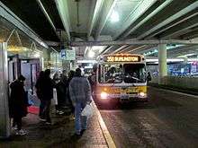
Seven MBTA Bus routes terminate at the ground-level busways at Alewife:
- 62 Bedford V.A. Hospital - Alewife Station via Lexington Center & Arlington Heights
- 67 Turkey Hill - Alewife Station via Arlington Center
- 76 Hanscom/Lincoln Labs - Alewife Station via Lexington Center & Civil Air Terminal
- 79 Arlington Heights - Alewife Station via Massachusetts Avenue
- 84 Arlmont Village - Alewife Station
- 350 North Burlington - Alewife Station via Burlington Mall
- 351 Oak Park/Bedford Woods - Alewife Station via Middlesex Turnpike
The 83 Rindge Avenue - Central Square, Cambridge via Porter Square Station terminates nearby at Russell Field. It is not possible to turn left from Alewife Brook Parkway onto Rindge Avenue, preventing the bus from serving Alewife directly. The bus stop is connected to Alewife by a short spur of the Cambridge Linear Park.
Alewife station is also served by several private-carrier routes:
- The Route 128 Business Council provides daily shuttle bus services from Alewife to many companies along the Route 2 and Route 128 corridor. Five routes are open to all riders: A (Alewife Station - Wyman Street), B (Alewife Station - Prospect Hill/City Point), C (Alewife Station - Winter Street), D (Alewife Station - Winter Street), and The REV (Hartwell Area Shuttle). Two private routes to Windsor Village and Vox on Two are also run.[7]
- Go Bus (formerly World Wide Bus) provides intercity bus service between Alewife, Riverside, and New York City. The service began in October 2010.[8]
Station layout
| G | Street Level | Exits/Entrances |
| M | Mezzanine | Fare control, to Exits/Entrances |
| P Platform level |
Inbound | ← Red Line alighting passengers only → Red Line toward Ashmont/Braintree (Davis) → |
| Island platform, doors will open on the left/right | ||
| Inbound | ← Red Line alighting passengers only → Red Line toward Ashmont/Braintree (Davis) → | |
There is one island platform serving two tracks. The tracks extend past the station to store terminating trains.
Bicycle facilities
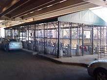
On September 18, 2008, two bike parking cages opened at the Alewife station. The cages can hold up to 150 bikes each. Previously, access to these cages required a free special Bike CharlieCard. Beginning in 2013, the MBTA allowed any CharlieCard to be registered for bike cage access. The cages are covered, enclosed with security fences, and watched by security cameras.[9]
Arts on the Line
As a part of the Red Line Northwest Extension, Alewife was included as one of the stations involved in the Arts on the Line program. Arts on the Line was devised to bring art into the MBTA's subway stations in the late 1970s and early 1980s. It was the first program of its kind in the United States and became the model for similar drives for art across the country.[10]:5
Six of the original twenty artworks are located at Alewife station.[11] These works are:
- Untitled by Richard Fleischner - A 3-acre (12,000 m2) large environmental work containing an artificial pond and large granite blocks
- Untitled by David Davidson - 200 feet (61 m) of abstractly painted, light blue tiles arranged in various ways
- Alewife Cows by Joel Janowitz - A mural of a false exit to the bus terminal with cows grazing in a pasture outside.
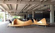
- Untitled (Kiss and Ride) by William Keyser, Jr. - Two sculptural benches for passengers waiting for pick-up at the station's "kiss and ride" automobile entrance
- The End of the Red Line by Alejandro and Moira Sina - 1000 neon art tubes suspended from the ceiling of the station directly over one of the tracks
- Untitled by Nancy Webb - 100 6" square tiles scattered throughout the station lobby with low relief images of plants and animals found in the Alewife Brook Reservation
Notes
- 1 2 Belcher, Jonathan (28 December 2013). "Changes to Transit Service in the MBTA district" (PDF). NETransit. Retrieved 9 February 2014.
- ↑ "Ridership and Service Statistics" (PDF) (14th ed.). Massachusetts Bay Transportation Authority. 2014.
- ↑ Joint Board for the Metropolitan Master Highway Plan (1 February 1948). The Master Highway Plan for the Boston Metropolitan Area.
- ↑ Weingroff, Richard F. (July–August 2013). "Busting the Trust". Public Roads. Federal Highway Administration. 77 (1). Retrieved 17 January 2014.
- ↑ Flint, Anthony (23 February 2003). "GIVING DENSITY A BAD NAME". Boston Globe – via Highbeam Research. (Subscription required (help)).
- ↑ Long, Tom (April 13, 2008). "'T' says it hasn't the funds to expand Alewife garage". The Boston Globe.
- ↑ "Shuttle Schedules". Route 128 Business Council. Retrieved June 30, 2017.
- ↑ Thomas, Sarah (2010-10-19). "NYC-bound buses will roll from Newton, Cambridge". Boston.com. Retrieved 2012-04-05.
- ↑ "Bikes on the T". MBTA. 19 January 2010. Retrieved 5 April 2015.
- ↑ Massachusetts Bay Transportation Authority (3 May 1985). Red Line Northwest Extension. Retrieved 10 August 2015.
- ↑ Arts on the Line:Alewife Station Archived 2011-07-21 at the Wayback Machine.. Cambridge Arts Council. 2002. Accessed May 30, 2010
External links
| Wikimedia Commons has media related to Alewife (MBTA station). |