Abbottabad District
| Abbottabad District ایبٹ آباد | |
|---|---|
| District | |
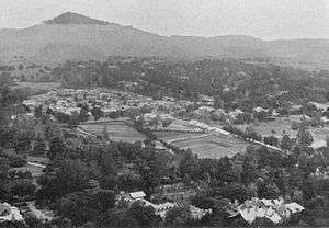 A picture of Abbottabad city taken in 1907 | |
 | |
| Coordinates: 34°00′N 73°00′E / 34.000°N 73.000°ECoordinates: 34°00′N 73°00′E / 34.000°N 73.000°E | |
| Country |
|
| Province | Khyber Pakhtunkhwa |
| Headquarters | Abbottabad |
| Area[1] | |
| • Total | 1,967 km2 (759 sq mi) |
| Population (2017)[2] | |
| • Total | 1,332,912 |
| • Density | 680/km2 (1,800/sq mi) |
| Time zone | UTC+5 (PKT) |
| Number of union councils | 51 |
| Number of Tehsils | 2 |
| Website |
www |
Abbottabad District (Urdu: ایبٹ آباد) is located in Khyber Pakhtunkhwa province of Pakistan. The district covers an area of 1,969 km2, with the city of Abbottabad being the principal town.[3] Neighbouring districts are Mansehra to the north, Muzaffarabad to the east, Haripur to the west, and Rawalpindi to the south.[4]
History
Origin of name
The district is named after Major James Abbott, the first deputy commissioner of Hazara (1849–1853).[4]
Hazara
During British rule Abbottabad became the capital of Hazara division, which was named after and contained the Hazara valley, a small valley in the outermost Himalayas, between the Indus in the west and Kashmir in the east.[5]
The current Abbottabad District was originally a tehsil of Hazara, the Imperial Gazetteer of India described it as follows:
| “ | Tahsīl of Hazāra District, North-West Frontier Province, lying between 33°49' and 34° 22' N. and 72°55' and 73° 31' E., with an area of 715 square miles (1,850 km2). It is bounded on the east by the Jhelum, which divides it from Pūnch and the Punjab District of Rawalpindi; and it comprises part of the mountain valleys drained by the Dor and Harroh rivers, together with the hill country eastward. The hill-sides to the north and north-east are covered with timber forest. The population in 1901 was 194,632, compared with 175,735 in 1891. It contains the towns of ABBOTTABAD (population, 7,764), the tahsil and District headquarters, and NAWASHAHR (4,114); and 359 villages. The land revenue and cesses amounted in 1903-4 to Rs. 97,000.[6] | ” |
In 1976 the tehsils of Mansehra and Battagram were separated into the new Mansehra District, while the tehsil of Haripur became a separate district in 1991.[7]:8
Demography
The population counted in 1998 census was 881,000.[1] According to an estimate this had risen to 1.05 million in 2008.[8] according to the old Hazara gazetteers the main tribes here are the Karlal , Turks, Dhund Abbasis, Tanolis, Tareen's, Awans, Sulemankhel, Jadoons, Qureshi, Mughals, Gujjars, Syeds and Sattis.[9]
The major language of the area is Hindko, which in the 1981 census was the mother tongue of 95% of households.[10] The variety spoken in the city of Abbottabad has formed the basis of a literary language.[11] It is very close to the Hindko varieties of Mansehra: the two share 86% of their basic basic vocabulary.[12] In the Galliat region in the southeast of the district, the language is still known as Hindko but becomes more different and gradually transitions into the core dialects of Pahari.[13] Other languages are overall more common in urban areas: in the 1998 census, 2.3% of the population reported their language as Punjabi (rising to 10.8% in urban areas), while the share of Pashto was 2.2% (8.4% in urban areas) and that of Urdu – 1.1% (5.1% in urban areas).[7]:18
Parks and protected areas
Under the Khyber Pakhtunkhwa Wildlife (Protection, Preservation, Conservation and Management) Act of 1975, two areas have been designated with the district: Ayubia National Park and Qalanderabad game reserve.[14] Both areas cover only 6% of the landed area of the district.[14]
The Ayubia National Park was established in 1984, this park covers an area of over 3,312 ha.[14]
The Qalanderabad game reserve was established in 1980 with an area of 8,940ha.[14]
Subdivisions
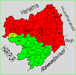
Abbottabad district is divided into two tehsils, Abbottabad Tehsil and Havelian Tehsil as well as one urban administration area – Nawanshehr. There are fifty-one Union Councils in the district, 38 in Abbottabad tehsil and 13 in Havelian.
Election 2008
With the announcement by the Election commission of Pakistan that elections would be held on 8 January 2008[15] more than a dozen candidates filed their nomination papers in Abbottabad.[16]
Political campaigns
Abbottabad was the centre of the Sooba Hazara movement that started after national assembly passed 18th amendment to change the name of province from North West Frontier Province (NWFP) to Khyber Pakhtunkhwa. The former governor of the province has been vocal in this opposition to the new name[17]
Provincial assembly
The district is represented in the provincial assembly by four elected MPAs (PK-36 to PK-39):[18]
Education
According to the Alif Ailaan Pakistan District Education Rankings 2015, Abbottabad is ranked 31 out of 148 districts in terms of education. For facilities and infrastructure, the district is ranked 72 out of 148.[19]
See also
References
| Wikimedia Commons has media related to Abbottabad District. |
- 1 2 "Abbottabad District at a Glance". Islamabad: Population Census Organization. Archived from the original on January 2, 2012. Retrieved 3 March 2012.
- ↑ "DISTRICT WISE CENSUS RESULTS CENSUS 2017" (PDF). www.pbscensus.gov.pk. Archived from the original (PDF) on 2017-08-29. Retrieved 2017-09-01.
- ↑ Geography of District Abbottabad Archived November 29, 2007, at the Wayback Machine.
- 1 2 IUCN Pakistan (2004). Abbottabad – State of the environment and Development. IUCN Pakistan and Khyber Pukhtoonkhwa: Karachi, p. 2.
- ↑ Hazara – Nordisk familjebok
- ↑ Imperial Gazetteer of India, v. 5, p. 1
- 1 2 1998 District census report of Abbottabad. Census publication. 32. Islamabad: Population Census Organization, Statistics Division, Government of Pakistan. 1999.
- ↑ District Profile: Northern Khyber Pakhtunkhwa – Abbottabad Archived May 16, 2008, at the Wayback Machine.
- ↑ ELECTIONS 2002 (Hazara Division) – Daily times Pakistan Archived June 6, 2011, at the Wayback Machine.
- ↑ 1981 District Census report of Abbottabad. District Census Report. 24. Islamabad: Population Census Organization, Statistics Division, Government of Pakistan. 1983. p. 76. The data is specifically for Abbottabad Tehsil; the only other tehsil of the district has since been promoted into the separate district of Haripur.
- ↑ Rahman, Tariq (1996). Language and politics in Pakistan. Oxford University Press. pp. 211–14. ISBN 978-0-19-577692-8.
- ↑
The figure is from:
- Lothers, Michael; Lothers, Laura (2010). Pahari and Pothwari: a sociolinguistic survey (Report). SIL Electronic Survey Reports. 2010-012. p. 24.
- Rensch, Calvin R. (1992). "The Language Environment of Hindko-Speaking People". In O'Leary, Clare F.; Rensch, Calvin R.; Hallberg, Calinda E. Hindko and Gujari. Sociolinguistic Survey of Northern Pakistan. Islamabad: National Institute of Pakistan Studies, Quaid-i-Azam University and Summer Institute of Linguistics. p. 56. ISBN 969-8023-13-5.
- ↑ Lothers & Lothers 2010, pp. 2, 5, 24ff.
- 1 2 3 4 IUCN Pakistan (2004). Abbottabad – State of the environment and Development. IUCN Pakistan and Khyber Pakhtunkhwa: Karachi, p. 50.
- ↑ 2008 Elections – ELECTION COMMISSION OF PAKISTAN Archived 2008-01-17 at the Wayback Machine.
- ↑ Election campaign starts in Abbottabad – Associated press of Pakistan
- ↑ Complete strike on riots anniversary: Hazara to get separate identity soon: Baba
- ↑ PF-48 (Abbottabad-V) Result: Announced Archived 2012-11-15 at the Wayback Machine.
- ↑ "Individual district profile link, 2015". Alif Ailaan. Archived from the original on 2016-01-08. Retrieved 2015-05-07.
Provincial capital: Peshawar | ||
| Divisions | Districts |  |
| Bannu | ||
| Dera Ismail Khan | ||
| Hazara | ||
| Kohat | ||
| Malakand | ||
| Mardan | ||
| Peshawar | ||