Mount Canobolas
| Mount Canobolas | |
|---|---|
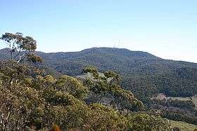 Mount Canobolas from the Pinnacle. | |
| Highest point | |
| Elevation | 1,397 m (4,583 ft) [1] |
| Coordinates | 33°20′39″S 148°58′56″E / 33.344253°S 148.982309°ECoordinates: 33°20′39″S 148°58′56″E / 33.344253°S 148.982309°E [2] |
| Geography | |
 Mount Canobolas Location in New South Wales | |
| Location | Central Tablelands, New South Wales, Australia |
| Parent range | Main Range, Great Dividing Range |
| Topo map | Cudal |
| Geology | |
| Mountain type | Extinct volcano |
| Climbing | |
| First ascent | 1835 – Major Thomas Mitchell (European) |
| Easiest route | Drive |
Mount Canobolas, a mountain on a spur of the Great Dividing Range, is located in the Central Tablelands region of New South Wales, Australia.
With an elevation of 1,390 metres (4,560 ft) above sea level,[1] Mount Canobolas, an extinct volcano, is the highest mountain in the region. Situated 13 kilometres (8.1 mi) southwest of the city of Orange, it is about 250 kilometres (155 mi) west of Sydney.
The northern slopes of the mountain, with fertile volcanic soil, are popular cold-climate wine producing area.
Etymology
The name comes from two Aboriginal words, "Gaahna Bula". This means "two shoulders" which refers to the summits of Mount Canobolas and Young Man Canobolas.
Description
There is a 360 degree view from the summit, which is often snow-capped in winter. The mountain is now part of a 15-square-kilometre (5.8 sq mi) area controlled by the NSW National Parks & Wildlife Service, which offers various walks: to Bald Hill; to Young Man Canobolas; Federal Falls to Mount Towac, and other locations.[3] The volcanic peaks give wide views and there are some attractive waterfalls.
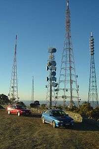
The top of the mountain is now dominated by numerous towers used for television and radio transmissions across large areas of central New South Wales. These transmitters include towers for Airservices Australia, Royal Australian Air Force, Prime7, WIN Television, Australian Broadcasting Corporation and Southern Cross Nine.
Each year the Orange Community runs the Great Volcanic Mountain Challenge, an 11-kilometre (6.8 mi) walk and fun run from the Pinnacle to the Summit of Mount Canobolas by the volcanic plugs of Mount Towac and Young Man Canobolas.[4] The inaugural event was held in 2006.[5]
Mount Canobolas is an extinct volcanic complex which erupted in several phases between 13 and 11 million years ago, making the mountain a relatively recent geological feature. Earlier eruptions were less violent with free flowing lavas reaching a maximum coverage extent of approximately. Later eruptions became more violent, and producing increasingly viscous lavas with less extensive coverage.
The contemporary landscape of Mount Canobolas exhibits erosional features dominated by several remnant peaks. Additional volcanic features are present within the zone of volcanic influence, including vents, dykes, peaks, domes and plugs.
The mountain's geologic history has yielded a variety of landforms which provide a range of environmental habitats, and notably rocky outcrops harbouring rare species of lichens. There are cliff features with waterfalls, such as the popular recreation locality, Federal Falls. Mount Canobolas was listed on the Register of the National Estate because of its geological significance before its closure in 2007.[6]
Indigenous use
Mount Canobolas is significant to the indigenous Wiradjuri people of the area. On the peak and nearby there are several significant sites, including rock carving, an ax grinding site and campsites.
Highest point claims
Mount Canobolas is not, as is sometimes claimed in tourism brochures,[7] the highest point between Australia's Great Dividing Range and Africa, with both Mount Zeil in Australia's Northern Territory and Mount Woodroffe in South Australia being higher, at 1,531 metres (5,023 ft) and 1,435 metres (4,708 ft), respectively. This would in any case be an insignificant claim to fame, since many of the tallest peaks in the Great Dividing Range are in fact further west than Mount Canobolas is. For example, Mount Bogong in Victoria at 1,986 metres (6,516 ft) and 36°44′S 147°18′E / 36.733°S 147.300°E is 591 metres (1,939 ft) higher and almost a degree and a half longitude further west. This translates to a difference of around 125 kilometres (78 mi) using the degree length formula.
The islands of Réunion and Madagascar also have higher peaks and are between the Ging Range and Africa.
Fires on the mountain
A bushfire affected most of the northern area of Mount Canoloblas in February 2018. All areas of this park except for the summit of Mount Canobolas are closed due to the effects of bushfire. The park experienced a major bushfire in February 2018 and there is a danger of falling trees and branches over the coming months. In addition a large amount of walking track infrastructure has been damaged. It will take some time to improve visitor safety and repair walking track infrastructure. While visitors are welcome at the summit of Mount Canobolas, they are reminded not to enter burnt areas of the park including the walking tracks.[8]
Wild fire frequency is poorly recorded, however it is believed to be quite low. The floristic composition suggests that the vegetation has evolved largely in the absence of regular intense fire.
A major fire in 1967 affected 415 ha in the northern section of the Conservation area. One major wildfire affected 414 ha in the western part of the Conservation area in 1982 and another major fire to the south in 1985. Information from local land holders indicates that the mountain was subjected to annual low intensity burning by previous occupiers to maintain fresh feed for their stock during the 1940s and 1950s.[9]
See also
References
- 1 2 "Map of Mount Canobolas, NSW". Bonzle Digital Atlas of Australia. Retrieved 27 May 2015.
- ↑ "Mount Canobolas". Geographical Names Register (GNR) of NSW. Geographical Names Board of New South Wales. Retrieved 27 May 2015.
- ↑ "Mount Canobolas State Conservation Area". Department of Environment and Climate Change NSW. Retrieved 5 May 2007.
- ↑ "Great Volcanic Mountain Challenge".
- ↑ "Runners facing uphill challenge - Course as tough as ever: Davis". Central Western Daily. 24 March 2007. Retrieved 5 May 2007.
- ↑ "Mount Canobolas State Conservation Area". NSW Government. Retrieved 9 June 2014.
- ↑ "Orange Museum" (PDF).
- ↑ "National Parks - Mount Canobolas State Conservation Area".
- ↑ NSW National Parks and Wildlife Service (October 2003). "Canobolas State Conservation Area Management Plan" (PDF).