Montmajor
| Montmajor | |||
|---|---|---|---|
| Municipality | |||
 Market square, Montmajor | |||
| |||
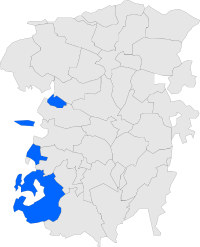 Map showing location within Berguedà | |||
 Montmajor Location in Catalonia  Montmajor Montmajor (Spain) | |||
| Coordinates: 42°01′08″N 1°44′10″E / 42.019°N 1.736°ECoordinates: 42°01′08″N 1°44′10″E / 42.019°N 1.736°E | |||
| Country |
| ||
| Community |
| ||
| Province | Barcelona | ||
| Comarca | Berguedà | ||
| Government | |||
| • Mayor | Maria Teresa Marmí Figols (2015)[1] (CiU) | ||
| Area[2] | |||
| • Total | 76.5 km2 (29.5 sq mi) | ||
| Elevation | 756 m (2,480 ft) | ||
| Population (2014)[1] | |||
| • Total | 476 | ||
| • Density | 6.2/km2 (16/sq mi) | ||
| Demonym(s) | Montmajorenc, montmajorenca | ||
| Website |
montmajor | ||

Montmajor is a municipality in the comarca of Berguedà, Catalonia.
Geography
Montmajor is made up of four distinct enclaves, quite separated from one another. The principal area of the municipality lies east of the town of Navès, which is in the comarca of Solsonès. The northernmost enclave is Catllarí (5.45 km²), which is surrounded by the municipalities of Fígols, Castellar del Riu, and Guixers. Comesposades (8.01 km²), is separated from the main town by L'Espunyola. Valielles (3.20 km²), meanwhile, is an enclave completely surrounded by Solsonès.
References
- 1 2 "Ajuntament de Montmajor". Generalitat of Catalonia. Retrieved 2015-11-13.
- ↑ "El municipi en xifres: Montmajor". Statistical Institute of Catalonia. Retrieved 2015-11-23.
External links
- Town Website
- Government data pages (in Catalan)
Places adjacent to Montmajor | |
|---|---|
.svg.png)
This article is issued from
Wikipedia.
The text is licensed under Creative Commons - Attribution - Sharealike.
Additional terms may apply for the media files.