Sant Julià de Cerdanyola
| Sant Julià de Cerdanyola | |||
|---|---|---|---|
| Municipality | |||
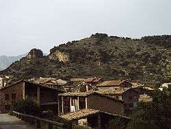 View of the town | |||
| |||
 Sant Julià de Cerdanyola Location in Catalonia  Sant Julià de Cerdanyola Sant Julià de Cerdanyola (Spain) | |||
| Coordinates: 42°13′32″N 1°53′38″E / 42.22556°N 1.89389°ECoordinates: 42°13′32″N 1°53′38″E / 42.22556°N 1.89389°E | |||
| Country |
| ||
| Community |
| ||
| Province | Barcelona | ||
| Comarca | Berguedà | ||
| Government | |||
| • Mayor | Agustí Elias Cunill (2015)[1] (Cerdanyola-AM) | ||
| Area[2] | |||
| • Total | 11.8 km2 (4.6 sq mi) | ||
| Elevation | 650 m (2,130 ft) | ||
| Population (2014)[1] | |||
| • Total | 239 | ||
| • Density | 20/km2 (52/sq mi) | ||
| Demonym(s) | Cerdanyolenc, cerdanyolenca | ||
| Website |
www | ||


Sant Julià de Cerdanyola is a town and municipality in the comarca of Berguedà, in Catalonia.
Geography
The town is located in a high hollow in the Pyrenees of Berguedà, at 1000 meters above sea level. The main access road to the town is a steep, winding highway coming from the town of Guardiola de Berguedà, in the Valley of the Llobregat below.
Celebrations
The town festival is celebrated on 5 December. On Christmas Eve, the inhabitants of the town also celebrate the Fia-Faia, a pre-Christian commemoration of the solstice where bundles of Cephalaria leucanta, called faies, are brought from a bonfire outside town to Plaça Catalunya in the center of town.
References
- 1 2 "Ajuntament de Sant Julià de Cerdanyola". Generalitat of Catalonia. Retrieved 2015-11-13.
- ↑ "El municipi en xifres: Sant Julià de Cerdanyola". Statistical Institute of Catalonia. Retrieved 2015-11-23.
External links
- Town website (in Catalan)
- Government data pages (in Catalan)
Places adjacent to Sant Julià de Cerdanyola | ||||||||||
|---|---|---|---|---|---|---|---|---|---|---|
| ||||||||||
.svg.png)
This article is issued from
Wikipedia.
The text is licensed under Creative Commons - Attribution - Sharealike.
Additional terms may apply for the media files.