Sant Esteve Sesrovires
| Sant Esteve Sesrovires | |
|---|---|
| Municipality | |
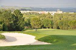 Barcelona Golf Club, with Sant Esteve Sesrovires behind | |
 Sant Esteve Sesrovires Location in Catalonia  Sant Esteve Sesrovires Sant Esteve Sesrovires (Catalonia)  Sant Esteve Sesrovires Sant Esteve Sesrovires (Spain) | |
| Coordinates: 41°29′42″N 1°52′28″E / 41.49500°N 1.87444°ECoordinates: 41°29′42″N 1°52′28″E / 41.49500°N 1.87444°E | |
| Country |
|
| Community |
|
| Province | Barcelona |
| Comarca | Baix Llobregat |
| Government | |
| • Mayor | Carme Rallo Casanovas (2015)[1] |
| Area[2] | |
| • Total | 18.6 km2 (7.2 sq mi) |
| Elevation | 183 m (600 ft) |
| Population (2014)[1] | |
| • Total | 7,542 |
| • Density | 410/km2 (1,100/sq mi) |
| Demonym(s) | Sesrovirenc/-a |
| Website |
sesrovires |
Sant Esteve Sesrovires (Catalan pronunciation: [ˈsant əsˈteβə səzruˈβiɾəs]; Old Catalan for "Saint Stephen the-Oak-Woods") is a municipality in the comarca of the Baix Llobregat in Catalonia, Spain. It is situated on the left bank of the Anoia river, and is served by the FGC railway line R6 from Barcelona and Martorell to Igualada and by the road from Martorell to Capellades.
Demography
| 1900 | 1930 | 1950 | 1970 | 1986 | 2002 |
|---|---|---|---|---|---|
| 839 | 910 | 859 | 1084 | 1708 | 5783 |
References
- 1 2 "Ajuntament de Sant Esteve Sesrovires". Generalitat of Catalonia. Retrieved 2015-11-13.
- ↑ "El municipi en xifres: Sant Esteve Sesrovires". Statistical Institute of Catalonia. Retrieved 2015-11-23.
External links
- Government data pages (in Catalan)
Places adjacent to Sant Esteve Sesrovires | ||||||||||
|---|---|---|---|---|---|---|---|---|---|---|
| ||||||||||
| Autoritat del Transport Metropolità Ferrocarrils de la Generalitat de Catalunya | ||||
|---|---|---|---|---|
| Line R6 | ||||
| Barcelona (Plaça d'Espanya) |
↔ | Sant Esteve Sesrovires | ↔ | Igualada |
.svg.png)
This article is issued from
Wikipedia.
The text is licensed under Creative Commons - Attribution - Sharealike.
Additional terms may apply for the media files.