Borredà
| Borredà | ||
|---|---|---|
| Municipality | ||
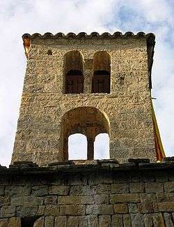 Belfry of Sant Sadurní de Rotgers | ||
| ||
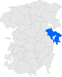 Location in Berguedà | ||
 Borredà Location in Catalonia  Borredà Borredà (Spain) | ||
| Coordinates: 42°8′17″N 1°59′46″E / 42.13806°N 1.99611°ECoordinates: 42°8′17″N 1°59′46″E / 42.13806°N 1.99611°E | ||
| Country |
| |
| Community |
| |
| Province | Barcelona | |
| Comarca | Berguedà | |
| Government | ||
| • Mayor | Joan Roma Cunill (2015)[1] (CP) | |
| Area[2] | ||
| • Total | 43.4 km2 (16.8 sq mi) | |
| Elevation | 854 m (2,802 ft) | |
| Population (2014)[1] | ||
| • Total | 540 | |
| • Density | 12/km2 (32/sq mi) | |
| Demonym(s) | Borredanès, borredanesa | |
| Website |
borreda | |
Borredà (Catalan pronunciation: [burəˈða]) is a municipality in the comarca of the Berguedà in Catalonia, Spain. It is situated in the upper valley of the Margençol river in the east of the comarca. There are several notable houses from the 17th and 18th centuries. The Romanesque church of Sant Sadurní de Rotgers, a protected historico-artistic monument, can be reached by a mountain track. The village is served by the C-149 road between Berga and Sant Quirze de Besora. The municipality surrounds an exclave of Les Llosses.
Demography
| 1900 | 1930 | 1950 | 1970 | 1986 | 2007 |
|---|---|---|---|---|---|
| 837 | 1090 | 863 | 597 | 445 | 571 |
References
- 1 2 "Ajuntament de Borredà". Generalitat of Catalonia. Retrieved 2015-11-13.
- ↑ "El municipi en xifres: Borredà". Statistical Institute of Catalonia. Retrieved 2015-11-23.
External links
- Official website (in Catalan)
- Government data pages (in Catalan)
Places adjacent to Borredà | |
|---|---|
.svg.png)
This article is issued from
Wikipedia.
The text is licensed under Creative Commons - Attribution - Sharealike.
Additional terms may apply for the media files.