Pallejà
| Pallejà | ||
|---|---|---|
| Municipality | ||
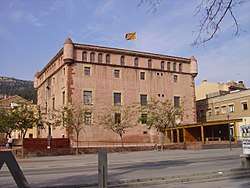 Castell de Pallejà | ||
| ||
 Pallejà Location in Catalonia  Pallejà Pallejà (Spain) | ||
| Coordinates: 41°25′27″N 1°59′52″E / 41.42417°N 1.99778°ECoordinates: 41°25′27″N 1°59′52″E / 41.42417°N 1.99778°E | ||
| Country |
| |
| Community |
| |
| Province | Barcelona | |
| Comarca | Baix Llobregat | |
| Government | ||
| • Mayor | Ascensión Ratia Checa (2015)[1] | |
| Area[2] | ||
| • Total | 8.3 km2 (3.2 sq mi) | |
| Elevation | 41 m (135 ft) | |
| Population (2014)[1] | ||
| • Total | 11,253 | |
| • Density | 1,400/km2 (3,500/sq mi) | |
| Website |
palleja | |

Pallejà is a municipality in the comarca of the Baix Llobregat in Catalonia, Spain. It is situated on the right bank of the Llobregat river, on the main N-II road. The main rail lines of the Llobregat corridor pass through the town: the station is served by the FGC services S4, S7 and S8. Pallejà castle was built in the seventeenth century on the site of an older fortress: it currently houses library.
Demography
| 1900 | 1930 | 1950 | 1970 | 1986 | 2005 |
|---|---|---|---|---|---|
| 656 | 1022 | 1065 | 4081 | 5919 | 10339 |
References
- 1 2 "Ajuntament de Pallejà". Generalitat of Catalonia. Retrieved 2015-11-13.
- ↑ "El municipi en xifres: Pallejà". Statistical Institute of Catalonia. Retrieved 2015-11-23.
External links
- Government data pages (in Catalan)
Places adjacent to Pallejà | |
|---|---|
.svg.png)
This article is issued from
Wikipedia.
The text is licensed under Creative Commons - Attribution - Sharealike.
Additional terms may apply for the media files.