Olesa de Bonesvalls
| Olesa de Bonesvalls | |||
|---|---|---|---|
| Municipality | |||
 | |||
| |||
 Olesa de Bonesvalls Location in Catalonia  Olesa de Bonesvalls Olesa de Bonesvalls (Spain) | |||
| Coordinates: 41°21′N 1°51′E / 41.350°N 1.850°ECoordinates: 41°21′N 1°51′E / 41.350°N 1.850°E | |||
| Country |
| ||
| Community |
| ||
| Province | Barcelona | ||
| Comarca | Alt Penedès | ||
| Government | |||
| • Mayor | Josep Ma. Tillo Bages (2015)[1] | ||
| Area[2] | |||
| • Total | 30.8 km2 (11.9 sq mi) | ||
| Elevation | 265 m (869 ft) | ||
| Population (2014)[1] | |||
| • Total | 1,735 | ||
| • Density | 56/km2 (150/sq mi) | ||
| Demonym(s) | Olesà, olesana | ||
| Website |
www | ||


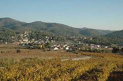
Olesa de Bonesvalls is a village and municipality in the Alt Penedès comarca in Catalonia, Spain. Until 1990 it was included in Garraf comarca.
It is located in the Garraf natural park, and includes its highest peak Montau, at 653m.[3] The land is stony karst with many caves, notably "Avenc de l'Esquerrà" at 348 m,[3] the deepest in Spain.
Its most notable building is Hospital de Cervelló, a fortified hostel complex for travellers dating from 1262, which has remained in good condition.[3]
Its economy is based mainly around agriculture, predominantly vineyards and orchards, and small local industry.
Its population was 1,735 in 2014.[1] The municipality is traversed by the road between the towns of Avinyonet del Penedès and Gavà.
Demography
| 1900 | 1930 | 1950 | 1970 | 1986 | 2014 |
|---|---|---|---|---|---|
| 643 | 513 | 389 | 372 | 329 | 1735 |
References
- 1 2 3 "Ajuntament d'Olesa de Bonesvalls". Generalitat of Catalonia. Retrieved 2015-11-13.
- ↑ "El municipi en xifres: Olesa de Bonesvalls". Statistical Institute of Catalonia. Retrieved 2015-11-23.
- 1 2 3 "Olesa de Bonesvalls". Gran Enciclopèdia Catalana. Retrieved 2017-12-24.
External links
- Official website (in Catalan)
- Government data pages (in Catalan)
Places adjacent to Olesa de Bonesvalls | ||||||||||
|---|---|---|---|---|---|---|---|---|---|---|
| ||||||||||
.svg.png)
This article is issued from
Wikipedia.
The text is licensed under Creative Commons - Attribution - Sharealike.
Additional terms may apply for the media files.