Mirabel, Tarn-et-Garonne
| Mirabel | ||
|---|---|---|
| Commune | ||
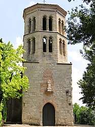 The church of Notre-Dame-des Misères, in Mirabel | ||
| ||
 Mirabel Location within Occitanie region  Mirabel | ||
| Coordinates: 44°08′41″N 1°25′15″E / 44.1447°N 1.4208°ECoordinates: 44°08′41″N 1°25′15″E / 44.1447°N 1.4208°E | ||
| Country | France | |
| Region | Occitanie | |
| Department | Tarn-et-Garonne | |
| Arrondissement | Montauban | |
| Canton | Quercy-Aveyron | |
| Intercommunality | Quercy caussadais | |
| Government | ||
| • Mayor (2008–2014) | Jacques Pautric | |
| Area1 | 32.07 km2 (12.38 sq mi) | |
| Population (2006)2 | 968 | |
| • Density | 30/km2 (78/sq mi) | |
| Time zone | UTC+1 (CET) | |
| • Summer (DST) | UTC+2 (CEST) | |
| INSEE/Postal code | 82110 /82440 | |
| Elevation |
79–217 m (259–712 ft) (avg. 150 m or 490 ft) | |
|
1 French Land Register data, which excludes lakes, ponds, glaciers > 1 km2 (0.386 sq mi or 247 acres) and river estuaries. 2 Population without double counting: residents of multiple communes (e.g., students and military personnel) only counted once. | ||
.svg.png)
Mirabel is a commune in the Tarn-et-Garonne department in the Occitanie region in southern France.
See also
References
| Wikimedia Commons has media related to Mirabel (Tarn-et-Garonne). |
This article is issued from
Wikipedia.
The text is licensed under Creative Commons - Attribution - Sharealike.
Additional terms may apply for the media files.