Castanet, Tarn-et-Garonne
| Castanet | |
|---|---|
| Commune | |
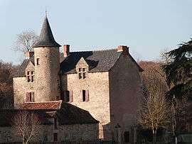 The Château of Cambayrac, in Castanet | |
 Castanet Location within Occitanie region  Castanet | |
| Coordinates: 44°16′03″N 1°57′03″E / 44.2675°N 1.9508°ECoordinates: 44°16′03″N 1°57′03″E / 44.2675°N 1.9508°E | |
| Country | France |
| Region | Occitanie |
| Department | Tarn-et-Garonne |
| Arrondissement | Montauban |
| Canton | Quercy-Rouergue |
| Intercommunality | Quercy Rouergue et des gorges de l'Aveyron |
| Government | |
| • Mayor (2001–2008) | René Gibergues |
| Area1 | 22.07 km2 (8.52 sq mi) |
| Population (2006)2 | 239 |
| • Density | 11/km2 (28/sq mi) |
| Time zone | UTC+1 (CET) |
| • Summer (DST) | UTC+2 (CEST) |
| INSEE/Postal code | 82029 /82160 |
| Elevation |
252–506 m (827–1,660 ft) (avg. 450 m or 1,480 ft) |
|
1 French Land Register data, which excludes lakes, ponds, glaciers > 1 km2 (0.386 sq mi or 247 acres) and river estuaries. 2 Population without double counting: residents of multiple communes (e.g., students and military personnel) only counted once. | |
Castanet is a commune in the Tarn-et-Garonne department in the Occitanie region in southern France.
See also
References
| Wikimedia Commons has media related to Castanet (Tarn-et-Garonne). |
This article is issued from
Wikipedia.
The text is licensed under Creative Commons - Attribution - Sharealike.
Additional terms may apply for the media files.