Bouloc-en-Quercy
| Bouloc-en-Quercy | |
|---|---|
| Commune | |
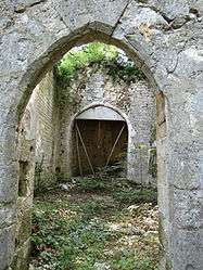 The remains of the chapel of Saint-Caprais, in Bouloc | |
 Bouloc-en-Quercy Location within Occitanie region  Bouloc-en-Quercy | |
| Coordinates: 44°18′01″N 1°07′38″E / 44.3003°N 1.1272°ECoordinates: 44°18′01″N 1°07′38″E / 44.3003°N 1.1272°E | |
| Country | France |
| Region | Occitanie |
| Department | Tarn-et-Garonne |
| Arrondissement | Castelsarrasin |
| Canton | Pays de Serres Sud-Quercy |
| Intercommunality | Quercy Pays de Serres |
| Government | |
| • Mayor (2008–2014) | Daniel Bonnemaison |
| Area1 | 14.81 km2 (5.72 sq mi) |
| Population (2006)2 | 215 |
| • Density | 15/km2 (38/sq mi) |
| Time zone | UTC+1 (CET) |
| • Summer (DST) | UTC+2 (CEST) |
| INSEE/Postal code | 82021 /82110 |
| Elevation |
116–265 m (381–869 ft) (avg. 240 m or 790 ft) |
|
1 French Land Register data, which excludes lakes, ponds, glaciers > 1 km2 (0.386 sq mi or 247 acres) and river estuaries. 2 Population without double counting: residents of multiple communes (e.g., students and military personnel) only counted once. | |
Bouloc-en-Quercy (before 2017: Bouloc)[1] is a commune in the Tarn-et-Garonne department in the Occitanie region in southern France.
Geography
The Séoune forms parts of the commune's western border. The Barguelonnette forms parts of the commune's southern border.
See also
References
- ↑ Décret n° 2017-149 7 February 2017 (in French)
| Wikimedia Commons has media related to Bouloc (Tarn-et-Garonne). |
This article is issued from
Wikipedia.
The text is licensed under Creative Commons - Attribution - Sharealike.
Additional terms may apply for the media files.