Cazes-Mondenard
| Cazes-Mondenard | ||
|---|---|---|
| Commune | ||
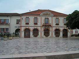 Cazes-Mondenard town hall | ||
| ||
 Cazes-Mondenard Location within Occitanie region  Cazes-Mondenard | ||
| Coordinates: 44°13′40″N 1°12′11″E / 44.2278°N 1.2031°ECoordinates: 44°13′40″N 1°12′11″E / 44.2278°N 1.2031°E | ||
| Country | France | |
| Region | Occitanie | |
| Department | Tarn-et-Garonne | |
| Arrondissement | Castelsarrasin | |
| Canton | Pays de Serres Sud-Quercy | |
| Government | ||
| • Mayor (2008–2014) | Hervé Andrieu | |
| Area1 | 58.23 km2 (22.48 sq mi) | |
| Population (2006)2 | 1,216 | |
| • Density | 21/km2 (54/sq mi) | |
| Time zone | UTC+1 (CET) | |
| • Summer (DST) | UTC+2 (CEST) | |
| INSEE/Postal code | 82042 /82110 | |
| Elevation |
93–253 m (305–830 ft) (avg. 143 m or 469 ft) | |
|
1 French Land Register data, which excludes lakes, ponds, glaciers > 1 km2 (0.386 sq mi or 247 acres) and river estuaries. 2 Population without double counting: residents of multiple communes (e.g., students and military personnel) only counted once. | ||
.svg.png)
Cazes-Mondenard is a commune in the Tarn-et-Garonne department in the Occitanie region in southern France.
Geography
The Barguelonne flows southwestward through the northern part of the commune.
See also
References
| Wikimedia Commons has media related to Cazes-Mondenard. |
This article is issued from
Wikipedia.
The text is licensed under Creative Commons - Attribution - Sharealike.
Additional terms may apply for the media files.