Le Pin, Tarn-et-Garonne
| Le Pin | |
|---|---|
| Commune | |
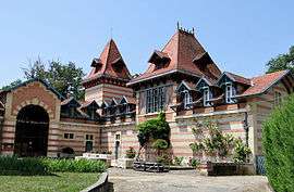 The Château Saint-Roch, in Le Pin | |
 Le Pin Location within Occitanie region  Le Pin | |
| Coordinates: 44°02′10″N 0°58′08″E / 44.0361°N 0.9689°ECoordinates: 44°02′10″N 0°58′08″E / 44.0361°N 0.9689°E | |
| Country | France |
| Region | Occitanie |
| Department | Tarn-et-Garonne |
| Arrondissement | Castelsarrasin |
| Canton | Garonne-Lomagne-Brulhois |
| Intercommunality | Deux Rives |
| Government | |
| • Mayor (2001–2008) | Renée Larochette |
| Area1 | 4.71 km2 (1.82 sq mi) |
| Population (2006)2 | 122 |
| • Density | 26/km2 (67/sq mi) |
| Time zone | UTC+1 (CET) |
| • Summer (DST) | UTC+2 (CEST) |
| INSEE/Postal code | 82139 /82340 |
| Elevation |
69–137 m (226–449 ft) (avg. 132 m or 433 ft) |
|
1 French Land Register data, which excludes lakes, ponds, glaciers > 1 km2 (0.386 sq mi or 247 acres) and river estuaries. 2 Population without double counting: residents of multiple communes (e.g., students and military personnel) only counted once. | |
Le Pin is a commune in the Tarn-et-Garonne department in the Occitanie region in southern France.
See also
References
| Wikimedia Commons has media related to Le Pin (Tarn-et-Garonne). |
This article is issued from
Wikipedia.
The text is licensed under Creative Commons - Attribution - Sharealike.
Additional terms may apply for the media files.