Castelsagrat
| Castelsagrat | ||
|---|---|---|
| Commune | ||
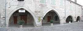 The square in Castelsagrat | ||
| ||
 Castelsagrat Location within Occitanie region  Castelsagrat | ||
| Coordinates: 44°11′06″N 0°56′52″E / 44.185°N 0.9478°ECoordinates: 44°11′06″N 0°56′52″E / 44.185°N 0.9478°E | ||
| Country | France | |
| Region | Occitanie | |
| Department | Tarn-et-Garonne | |
| Arrondissement | Castelsarrasin | |
| Canton | Valence | |
| Intercommunality | Deux Rives | |
| Government | ||
| • Mayor (2001–2008) | André Braman | |
| Area1 | 22.5 km2 (8.7 sq mi) | |
| Population (2006)2 | 552 | |
| • Density | 25/km2 (64/sq mi) | |
| Time zone | UTC+1 (CET) | |
| • Summer (DST) | UTC+2 (CEST) | |
| INSEE/Postal code | 82032 /82400 | |
| Elevation |
69–203 m (226–666 ft) (avg. 86 m or 282 ft) | |
|
1 French Land Register data, which excludes lakes, ponds, glaciers > 1 km2 (0.386 sq mi or 247 acres) and river estuaries. 2 Population without double counting: residents of multiple communes (e.g., students and military personnel) only counted once. | ||
.svg.png)
Castelsagrat is a commune in the Tarn-et-Garonne department in the Occitanie region in southern France.
Geography
The Séoune forms most of the commune's northern border. The Barguelonne forms all of the commune's south-eastern border.
See also
References
| Wikimedia Commons has media related to Castelsagrat. |
This article is issued from
Wikipedia.
The text is licensed under Creative Commons - Attribution - Sharealike.
Additional terms may apply for the media files.