Villebrumier
| Villebrumier | ||
|---|---|---|
| Commune | ||
 The town hall of Villebrumier | ||
| ||
 Villebrumier Location within Occitanie region  Villebrumier | ||
| Coordinates: 43°54′27″N 1°27′14″E / 43.9075°N 1.4539°ECoordinates: 43°54′27″N 1°27′14″E / 43.9075°N 1.4539°E | ||
| Country | France | |
| Region | Occitanie | |
| Department | Tarn-et-Garonne | |
| Arrondissement | Montauban | |
| Canton | Tarn-Tescou-Quercy vert | |
| Intercommunality | Terroir Grisolles Villebrumier | |
| Government | ||
| • Mayor (2001–2008) | Étienne Astoul | |
| Area1 | 11.38 km2 (4.39 sq mi) | |
| Population (2006)2 | 1,208 | |
| • Density | 110/km2 (270/sq mi) | |
| Time zone | UTC+1 (CET) | |
| • Summer (DST) | UTC+2 (CEST) | |
| INSEE/Postal code | 82194 /82370 | |
| Elevation |
75–201 m (246–659 ft) (avg. 90 m or 300 ft) | |
|
1 French Land Register data, which excludes lakes, ponds, glaciers > 1 km2 (0.386 sq mi or 247 acres) and river estuaries. 2 Population without double counting: residents of multiple communes (e.g., students and military personnel) only counted once. | ||
.svg.png)
Villebrumier is a commune in the Tarn-et-Garonne department in the Occitanie region in southern France.
Monuments
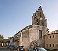 St. Theodard's church
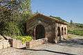 Laundry (1862)
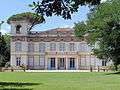 Castle of Villebrumier
See also
References
| Wikimedia Commons has media related to Villebrumier. |
This article is issued from
Wikipedia.
The text is licensed under Creative Commons - Attribution - Sharealike.
Additional terms may apply for the media files.