Manyara Region
| Manyara Region Mkoa wa Manyara (Swahili) | |
|---|---|
| Region | |
 | |
 Location in Tanzania | |
| Country | Tanzania |
| Zone | Northern |
| Capital | Babati |
| Government | |
| • Regional Commissioner | Elaston Mbwilo |
| Area | |
| • Total | 44,522 km2 (17,190 sq mi) |
| Population (2012) | |
| • Total | 1,425,131 |
| • Density | 32/km2 (83/sq mi) |
| Time zone | UTC+3 (EAT) |
| Postcode | 27xxx |
| Area code(s) | 027 |
| Website |
www |
Manyara Region is one of Tanzania's 31 administrative regions. The regional capital is the town of Babati. According to the 2012 national census, the region had a population of 1,425,131, which was lower than the pre-census projection of 1,497,555.[1]:page 2 For 2002-2012, the region's 3.2 percent average annual population growth rate was tied for the third highest in the country.[1]:page 4 It was also the 22nd most densely populated region with 32 people per square kilometre.[1]:page 6
Lake Manyara is in the northern part of the region. It is bordered to the north by the Arusha Region, to the northeast by the Kilimanjaro Region, to the east by the Tanga Region, to the south by the Dodoma Region, to the southwest by the Singida Region, and to the northwest by the Simiyu Region. The highest mountain in the Manyara Region is Mount Hanang.
Demographics
.jpg)
Manyara Region is inhabited by various ethnolinguistic groups and communities. The latter include the Assa people, Gorowa, Kw'adza, Mbugwe, Datooga, Maasai and Barabaig.
Administration
The regional commissioner of the Manyara Region is Elaston J. Mbwilo.[2]
Economy
Residents of the Manyara Region are mostly farmers. The region's economy is based on the mining of Tanzanite gems on the Mererani Hills in north on the border with the Arusha Region. Other sources of income are from tourism to the Tarangire National Park, which is entirely located in the region, and Lake Manyara National Park.
Transport
One paved road passes through the western part of Manyara Region. Paved trunk road T14 from Singida connects with trunk road T5 in Babati town. Trunk road T5 from Dodoma to Arusha passes through the region; it is paved from Babati up to Arusha.[3]
Districts
The region is administratively divided into six districts:
| Districts of Manyara Region | ||||||
|---|---|---|---|---|---|---|
| Map | District | Population (2012) | ||||
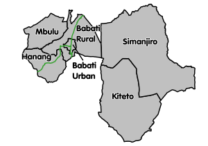 |
Babati Rural | 312,392 | ||||
| Babati Urban | 93,108 | |||||
| Hanang | 275,990 | |||||
| Kiteto | 244,669 | |||||
| Mbulu | 320,279 | |||||
| Simanjiro | 178,693 | |||||
| Total | 1,425,131 | |||||
See also
References
- 1 2 3 Population Distribution by Administrative Units, United Republic of Tanzania, 2013 Archived 2013-06-12 at the Wayback Machine.
- ↑ Kitabu cha Mawasiliano Serikalini, Tanzania Government Directory, 2012, page 170
- ↑ "Manyara Roads Network" (PDF). Tanroads. Archived from the original (PDF) on 20 December 2016. Retrieved 14 December 2016.
External links
| Wikimedia Commons has media related to Manyara Region. |
- "Manyara Region Road Network" (PDF). July 2008. Archived from the original (PDF) on 2012-09-01. Retrieved 2012-09-01.
| Mainland | ||
|---|---|---|
| Zanzibar | ||