Mbulu District
| Mbulu District | |
|---|---|
| District | |
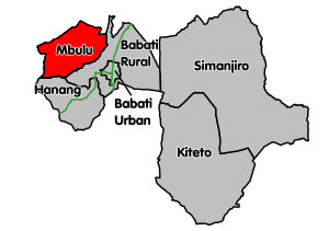 Mbulu District's location within Manyara Region. | |
| Country | Tanzania |
| Region | Manyara Region |
| Population (2012) | |
| • Total | 320,279 |
Mbulu District is one of the six districts of the Manyara Region of Tanzania. It is bordered to the north by the Arusha Region and Lake Eyasi, to the east by the Babati Rural District, to the south by the Hanang District, and to the west by the Singida Region.
According to the 2002 Tanzania National Census, Mbulu District had a population of 237,882 inhabitants.[1] According to the 2012 Tanzania National Census, the population of Mbulu District was 320,279.[2]
The District Commissioner is Chelestino Mofugo.[3] Mbulu District is, since the 2015 general election, divided into two election counties: Mbulu Mjini and Mbulu Vijijini.
The 2015-2020 members of parliaments are Zacharias Isaay (CCM) and Flatei Massay (CCM), for Mbulu Mjini and Mbulu Vijijini respectively.
The District is inhabited by people of different ethnic affiliations, especially the Iraqw people who are some of the earliest agro-pastoralists to migrate to what is now the Republic of Tanzania. Other native tribes are the Wahatzabeti living in Yaeda Chini, living a primitive life, and the Datooga people living in Mbulu Vijijini. People engage mainly in agriculture, keeping livestock and farming activities. There is plantation of onions in Bashay and wheat in many places.
The Mbulu District is decorated by mountains like Mount Guwang which is one of the attractive feature for tourists. There's also a hot spring in Hhaynu. The Manyara National Park is partly in Mbulu region where tourists can come and visit. There is a Sanu Parking longe in Mbulu town where guest can get accommodation.
Mbulu town has the Nyerere Stadium in Sanu Mbulu, the biggest stadium in whole Manyara Region for football and marathon. One of biggest hospitals in northern Tanzania is found in Mbulu: the Haydom Lutheran Hospital.
Administrative subdivisions
As of 2012, Mbulu District was administratively divided into 32 wards.[2]
Wards
|
|
|
|
The district headquarters at Mbulu is said to have started in 1905.
References
- ↑ Census, www.tanzania.go.tz
- 1 2 "Census 2012". National Bureau of Statistics. Retrieved 21 July 2016.
- ↑ "Archived copy". Archived from the original on January 25, 2006. Retrieved January 29, 2006.
External links
- Mbulu District Homepage for the 2002 Tanzania National Census
- Tanzanian Government Directory Database
Coordinates: 3°51′S 35°33′E / 3.85°S 35.55°E
| Authority control |
|---|