Mbeya Region
| Mbeya Region Mkoa wa Mbeya (Swahili) | |
|---|---|
| Region | |
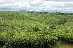 Tea fields in Tukuyu | |
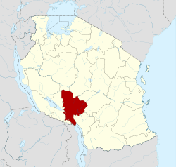 Location in Tanzania | |
| Country | Tanzania |
| Zone | Southern Highlands |
| Capital | Mbeya |
| Government | |
| • Regional Commissioner | Amos Gabriel Makalla |
| Area[1] | |
| • Total | 35,954 km2 (13,882 sq mi) |
| • Land | 35,493 km2 (13,704 sq mi) |
| • Water | 461 km2 (178 sq mi) |
| Population (2012) | |
| • Total | 2,707,410 |
| • Density | 75/km2 (200/sq mi) |
| Time zone | UTC+3 (EAT) |
| Postcode | 53xxx |
| Area code(s) | 025 |
| Website | Regional website |
Mbeya Region is one of Tanzania's 31 administrative regions. It is located in the country's southwest. The regional capital is the city of Mbeya. According to the 2012 national census, the region had a population of 2,707,410, which was lower than the pre-census projection of 2,822,396.[2]:page 2 For 2002-2012, the region's 2.7 percent average annual population growth rate was tied for the tenth highest in the country.[2]:page 4 It was also tied for the eighteenth most densely populated region with 45 people per square kilometre.[2]:page 6
In 2016, the town of Tunduma and the districts of Ileje, Mbozi, Momba and Songwe (created from the western part of Chunya District[3]) were split from Mbeya Region to create Songwe Region.[4][5] Mbeya Region is now bordered to the northwest by Tabora Region, to the northeast by Singida Region, to the east by Iringa Region, to the south by Songwe Region and Malawi, and to the west by Songwe Region.[6] Prior to the creation of Songwe Region, Mbeya Region covered an area of 62,420 square kilometres (24,100 sq mi).[7] It now covers an area of 35,954 square kilometres (13,882 sq mi).[1]
The commissioner for Mbeya Region is Amos Gabriel Makalla.[8]
Districts
In 2012, the region was administratively divided into eight districts:
| Districts of Mbeya Region in 2012 | |||||||
|---|---|---|---|---|---|---|---|
| Map | District | Population (2012) | |||||
 |
Chunya | 290,478 | |||||
| Ileje | 124,451 | ||||||
| Kyela | 221,490 | ||||||
| Mbarali | 300,517 | ||||||
| Mbeya | 690,598 | ||||||
| Mbozi | 446,339 | ||||||
| Momba | 294,380 | ||||||
| Rungwe | 339,157 | ||||||
| Total | 2,707,410 | ||||||
After the 2016 reorganization, Mbeya now comprises seven districts: Busokelo, Chunya, Kyela, Mbarali, Mbeya City, Mbeya Rural, and Rungwe.[6]
Geology
It was announced in February 2012 that the collapsed volcano approximately 200 km north of Mbeya, Mount Ngualla, contained one of the largest rare earth oxide deposits in the world.[9]
Writers from Mbeya Region
- Godfrey Mwakikagile
- Christopher Mwashinga
- Fadhy Mtanga
- Christopher Zacharia Lameck
References
- 1 2 "Mbeya Regional Profile" (PDF). Mbeya Regional Commissioner's Office. 2016. Retrieved 1 December 2017.
- 1 2 3 Population Distribution by Administrative Units, United Republic of Tanzania, 2013 Archived 2 May 2013 at the Wayback Machine.
- ↑ "History". Songwe District Council. Retrieved 1 December 2017.
- ↑ "History". Songwe Regional Commissioner's Office. Retrieved 1 December 2017.
- ↑ Mwakyusa, Alvar (4 February 2016). "Songwe is new region - with four districts". Daily News. Archived from the original on 5 February 2016. Retrieved 21 February 2017.
- 1 2 "Welcome to Mbeya Region". Mbeya Regional Commissioner Office. Archived from the original on 22 February 2017. Retrieved 21 February 2017.
- ↑ Statistical Abstract 2011, Tanzania National Bureau of Statistics Archived 5 November 2013 at the Wayback Machine.
- ↑ Kitabu cha Mawasiliano Serikalini, Tanzania Government Directory, 2012, page 173
- ↑ Peak Resources - Maiden Resource, Ngualla Rare Earth Project, ASX Announcement, 29 February 2012
| Mainland | ||
|---|---|---|
| Zanzibar | ||