Radohima
| Radohima | |
|---|---|
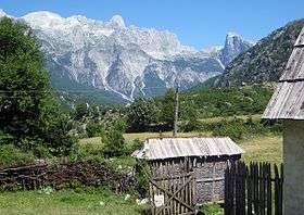 Radohima seen from Theth | |
| Highest point | |
| Elevation | 2,568 m (8,425 ft) [1][2] |
| Listing | Ultra |
| Coordinates | 42°25′38″N 19°43′33″E / 42.42722°N 19.72583°ECoordinates: 42°25′38″N 19°43′33″E / 42.42722°N 19.72583°E |
| Geography | |
| Location | Kukës, Albania |
| Parent range | Albanian Alps |
| Geology | |
| Age of rock | Triassic |
| Mountain type | Limestone |
Radohima (Albanian: Maja e Radohimës) is a mountain within the Albanian Alps in northern Albania.
Radohima rises between the Shala and Cem Valley. The massif of the Radohima has several other peaks with Maja e Radohimës at 2,568 metres (8,425 ft) being the highest peak of the massif. To the east, the mountain drops steeply over 1,500 metres into the valley of River Shala. The other peaks of the Radohima massif include Maja Tat 2,543 metres (8,343 ft), Maja Visens 2,517 metres (8,258 ft), Maja Reshkullit 2,496 metres (8,189 ft), and Maja Kuc 2,496 metres (8,189 ft).[3]
 View from Theth |
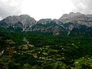
 Gropat e Radohimes |
 View from Theth |
See also
| Wikimedia Commons has media related to Radohima. |
References
- ↑ "ALBANIAN ALPS GEOTOPES" (PDF). lib.icimod.org. p. 8.
- ↑ "TREGUES SIPAS QARQEVE INDICATORS BY PREFECTURES" (PDF). Archived from the original (PDF) on 2011-07-24. Retrieved 2011-01-12.
- ↑ "Maja Radohines". summitpost.org.
This article is issued from
Wikipedia.
The text is licensed under Creative Commons - Attribution - Sharealike.
Additional terms may apply for the media files.