Kukës County
| Kukës County Qarku Kukës | ||
|---|---|---|
| County | ||
| ||
 | ||
| Coordinates: 42°N 20°E / 42°N 20°E | ||
| Country |
| |
| Municipality(s) | 3 | |
| Villages | 187 | |
| Seat | Kukës | |
| Government | ||
| • Council chairman | Abedin Oruçi | |
| Area | ||
| • Total | 2,374 km2 (917 sq mi) | |
| Area rank | 7th | |
| Population (2016) | ||
| • Total | 84,035[1] | |
| • Rank | 11th | |
| Time zone | UTC+1 (CET) | |
| • Summer (DST) | UTC+2 (CEST) | |
| NUTS Code | AL013 | |
| Website | Official Website | |

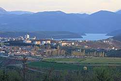
Kukës County (Albanian pronunciation: [ku:kəs]; Albanian: Qarku i Kukësit) is a landlocked county in northeastern Albania, with the capital in Kukës. The county spans 2,374 square kilometres (917 sq mi) and had a total population of 84,035 people as of 2016. The county borders on the counties of Dibër, Lezhë and Shkodër and the countries of Kosovo[lower-alpha 1] and the Republic of Macedonia. It is divided into three municipalities, including Has, Kukës and Tropojë.[2][3] The municipalities are further subdivided into 290 towns and villages in total.
The human presence in the lands of modern Kukës County can be traced back to the Bronze Ages, when ancient Illyrians, Dardanians and Romans established settlements in the region.[4] Several Illyrian tombs were discovered in the villages of Këneta and Kolsh close to Kukës.[5]
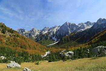
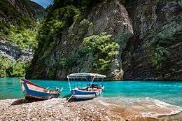
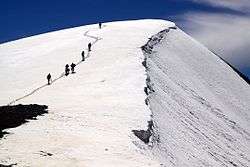
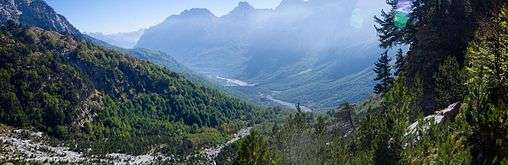
Kukës is predominantly mountainous and framed by mountain ranges including the Albanian Alps in the northwest which is typified by karst topography. The northeast is dominated by the mountains of Gjallica, Koritnik and Pashtrik, while the southeastern bound is mostly formed by the Korab and Sharr Mountains.[6] At 2,694 metres (8,839 ft), Maja Jezercë is the county's highest peak, and the second highest peak of Albania. Karst topography predominates in the county, resulting in specific landforms and hydrology because of the interaction of the karst and the region's watercourses. It is crossed and drained by the Drin river. The county is also home to the sources of rivers such as the Valbona, which originates south of Maja Jezercë and Gashi a notable tributary of Valbona.
Located in the north of Albania, the climate is alpine and continental.[7][8] Mean monthly temperature ranges between 11 °C (52 °F) (in January) and 25 °C (77 °F) (in July). Mean annual precipitation ranges between 900 millimetres (35 inches) and 3,000 millimetres (120 inches) depending on geographic region and prevailing climate type.
According to the last national census from 2011 this county has 85,292 inhabitants. They are mostly Muslim and a significant Catholic Christian minority are present. They speak the Gheg dialect.
Geography
Kukës is one of 12 counties of Albania, located in the north and northeast of the Northern Region. The county area is 2,374 km2 (917 sq mi) and the seventh largest county by area in Albania and the third largest in the Northern Region, behind Shkodër County and Dibër County. It is limited to the counties of Shkodër County in the west, Dibër County in the south, Lezhë County in the southeast, the countries of Kosovo in the east and northeast and Montenegro in the north and northwest. The county lies between latitudes 42° N, and longitudes 20° E. Its northernmost point is Çerem point at 42° 29' 52" northern latitude; the southernmost is Kalis point at 41° 50' 0" northern latitude; the westernmost point is Rrogam at 19° 50' 24" eastern longitude; and the easternmost point is Shishtavec at 20° 36' 0" eastern longitude.
The terrain of the county consists of small plains and high mountains. Elevations here range between 250 m (0.16 mi) and 2,200 m (1.4 mi).[9] The Albanian Alps are a high mountain range running through Tropojë across the northwest of the county. The northeast contain high and steep peaks including Gjallica, Koritnik and Pashtrik. Between these mountains are mostly narrow valleys, canyons and ravines. From southeast, the county is crossed by the Sharr and Korab Mountains.
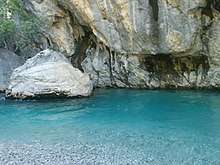
Hydrologically, the county lies almost entirely within the basin of the Drin and its tributaries. The river flows into the Adriatic Sea after crossing the county territory from the confluence of Black Drin and White Drin. On their way, its basin and zone of influence naturally correspond to the areas destined for agricultural use. Lake Fierza and Koman lies in the county and are fed and drained by rivers Black Drin and White Drin. Other notable rivers include Gashi and Valbona.
Phytogeographically, the county falls within the Dinaric Mountains mixed forests and Balkan mixed forests terrestrial ecoregion of the Palearctic Temperate broadleaf and mixed forest. The Balkan mixed forests occupy the eastern portion of the county. Inside the county, there are a national parks, a nature park and a nature reserve, which include the Valbonë Valley National Park, Korab-Koritnik Nature Park and the Gashi River Nature Reserve. The northern and eastern bound of the county forms a part of the European Green Belt, which serves as a retreat for endangered mammal and plant species.[10][11] Furthermore, the Gashi River was declared a UNESCO World Heritage Site as part of the Primeval beech forests of the Carpathians and other regions of Europe.[12]
Demography
With an estimated total population of around 85,292 people as of the INSTAT census of 2011, Dibër is the 11th most populous county in Albania.[13] The population density is 36 inhabitants per square kilometre (93/sq mi). Compared to 2001, the county had approximately 112,000 people. It has lost almost a quarter of its population in the last ten years. Kukës has the highest total fertility rate of Albania with 2.29 children per woman (compared to the national number of 1.54 children per woman).
The county is inhabited mostly by Albanians (84,31%) and is ethnically a homogeneous county in Albania. Minority groups include Macedonians (0.85%), Greeks (0.01%), Aromanians (0.01%) and Egyptians (0.00%).[14]
According to the 2011 census, 83.81% of the Albanian population within the county identify as Muslims. Although Christianity is the second largest religion in Kukës. 2.72 identify themselves as Christians; of these, Roman Catholics make up the largest group, accounting for 2.62% of the population, after which follows Eastern Orthodoxy (0.03%), Evangelism (0.03%) and other Christianity (0.04%). 0.33% of the population describes themselves as non-religious.[14]
Gallery

 Source of Gashi
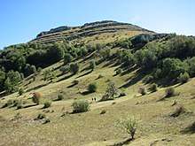
See also
| Wikimedia Commons has media related to Kukës County. |
Notes
- ↑ Kosovo is the subject of a territorial dispute between the Republic of Kosovo and the Republic of Serbia. The Republic of Kosovo unilaterally declared independence on 17 February 2008, but Serbia continues to claim it as part of its own sovereign territory. The two governments began to normalise relations in 2013, as part of the Brussels Agreement. Kosovo has received formal recognition as an independent state from 113 out of 193 United Nations member states.
References
- ↑ "Popullsia e Shqipërisë" (PDF). instat.gov.al (in Albanian). 19 February 2016. Archived from the original (PDF) on 12 April 2016.
- ↑ Law nr. 115/2014
- ↑ Law nr. 115/2014 Archived 2015-09-24 at the Wayback Machine.
- ↑ Bulletin of the Institute of Archaeology, 30-31, University of London. Institute of Archaeology, 1991, pp. 11–14
- ↑ Boardman, Edwards, John ,I. E. S. (1982). The Cambridge Ancient History. Cambridge University Press. p. 235. Retrieved 10 January 2016.
- ↑ "STRATEGJIA TERRITORIALE E NJËSISË VENDORE KUKËS" (PDF). kukesi.gov.al. p. 14.
- ↑ "PLANI I ZHVILLIMIT I BASHKISE KUKES" (PDF). rasp.org.al (in Albanian). p. 14. Archived from the original (PDF) on 2017-10-14.
- ↑ "Zona Funksionale Tropojë" (PDF). km.dldp.al (in Albanian). p. 5.
- ↑ "Resurset kryesore te Qarkut te Kukesit". kqk.gov.al (in Albanian).
- ↑ European Green Belt. "Brezi i Gjelbër Evropian" (PDF). europeangreenbelt.org (in Albanian). p. 2.
- ↑ Euronatur. "BEECH FORESTS ALONG THE GREEN BELT ALBANIA" (PDF). euronatur.org. p. 2.
- ↑ "PËRSHKRIMI I RRJETIT AKTUAL TË ZONAVE TË MBROJTURA" (PDF). mjedisi.gov.al (in Albanian). p. 2.
PËRSHKRIMI I RRJETIT AKTUAL TË ZONAVE TË MBROJTURA
- ↑ INSTAT. "Population and Housing Census" (PDF). instat.gov.al (in Albanian). p. 20. Archived from the original (PDF) on 2016-03-04.
- 1 2 INSTAT. "Population and Housing Census" (PDF). instat.gov.al (in Albanian). p. 39. Archived from the original (PDF) on 2016-03-04.
| |||||||||||||||||||||||||||