Shala (river)
| Shala | |
|---|---|
 | |
| Physical characteristics | |
| Main source |
Okol, Theth Shkodër County 950 m (3,120 ft) 42°25′18″N 19°45′29″E / 42.42167°N 19.75806°E |
| River mouth |
Lake Koman 175 m (574 ft) 42°12′5″N 19°49′1″E / 42.20139°N 19.81694°ECoordinates: 42°12′5″N 19°49′1″E / 42.20139°N 19.81694°E |
| Length | 36 km (22 mi) |
| Basin features | |
| Progression | Drin→ Adriatic Sea |
| Basin size | 269 km2 (104 sq mi) |
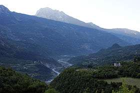
The Shalë (definite Albanian form: Shala) is a river flowing inside the Albanian Alps in northern Albania. Its source is in the Albanian Alps, near the village Theth, close to the border with Montenegro. The Shalë flows generally south through the municipal units Shalë, Shosh and Temal. It flows into the Koman Reservoir, fed and drained by the river Drin, near the village Telum.
See also
| Wikimedia Commons has media related to Shala. |
References
This article is issued from
Wikipedia.
The text is licensed under Creative Commons - Attribution - Sharealike.
Additional terms may apply for the media files.