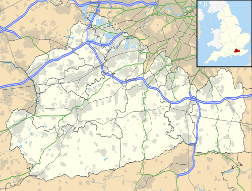
Stanwell
| Stanwell | |
|---|---|
 Parish Church of St Mary the Virgin | |
 Stanwell Stanwell shown within Surrey | |
| Area | 5.13 km2 (1.98 sq mi) |
| Population | 11,279 (2011 census)[1] |
| • Density | 2,199/km2 (5,700/sq mi) |
| OS grid reference | TQ055735 |
| District | |
| Shire county | |
| Region | |
| Country | England |
| Sovereign state | United Kingdom |
| Post town | Staines-upon-Thames |
| Postcode district | TW19 |
| Dialling code | 01784 |
| Police | Surrey |
| Fire | Surrey |
| Ambulance | South East Coast |
| EU Parliament | South East England |
| UK Parliament | |
Stanwell is an urban and suburban village in the Surrey borough of Spelthorne, 16 miles (26 km) WSW of Charing Cross and centred 1⁄2 mile (800 m) from the southern boundary of London Heathrow Airport, adjoining its cargo depot. It is the northernmost settlement in Surrey.
The semi-rural neighbourhood of Stanwell Moor has its own village association and is separated from the village centre by a field, large reservoir and dual carriageway, and includes most of the remaining village farms. However, it is included within a ward and parish of Stanwell. In common, both localities have large areas of reservoir and are within 2 miles (3 km) of a junction of the M25 London Orbital Motorway. To the west of the village proper stretch further areas of open land, much of which is part of the Metropolitan Green Belt and is important primarily for fish and bird life, including the Staines Moor SSSI and the Colne Valley regional park.
Stanwell lost land to a fraction of the adjoining airport and to Berkshire in the mid and late 20th century respectively. Its main industrial and business area, Poyle, was detached and added to Colnbrook, Berkshire, in 1995 due to the completion of the M25 London Orbital Motorway. Stanwell is adjoined by two towns and includes Ashford Hospital and the Staines Reservoirs named after these. The largest of its neighbours is Staines upon Thames which is a retail, entertainment, dining and leisure venue and has corporate offices. The nearest railway station is centred 1 mile (1.6 km) south, or 1 1⁄2 miles (2.4 km) south of the conservation area which has a partly medieval parish church, village green and brief winding section of street with buildings from the 17th to early 19th centuries, some with earlier elements.
History
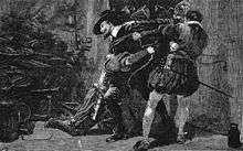
He arrested Guy Fawkes in the cellar of the Houses of Parliament when Fawkes was planting explosives to kill King James VI and I and was convicted of high treason, while rough justice was dispensed on others alleged to have conspired. Knyvet's actions, and those of a Roman Catholic peer who was forewarned, and of Edward Doubleday in preventing this plot from succeeding, are celebrated annually on Bonfire Night.
Knyvet often stayed at his earlier acquisition at Stanwell Manor, Stanwell, and rented Knyvett House, on the site of what later became 10, Downing Street, Westminster.
There are two theories regarding the origin of the name Stanwell. One is that it was named after St Ann(e)'s well in the village but the parish church has been dedicated according to all known records to St Mary. The second is that it means 'stone well' in turn referring to stony soil or the adjoining street to the south. The first few letters of the name are the same as in the name of neighbouring Staines-upon-Thames, which also is said to mean 'stones', in the same way as the Great Vowel Shift failed to influence the spelling and pronunciation of the contemporaneously pronounced Stane Streets (i.e. stone streets), the Old English for many of the stone-laid Roman roads in Britain.
The Domesday Book of 1086 records 'Stanwelle' held by Walter, son of Othere, Anglo Saxon names. Its domesday assets were: 15 hide, 4 mills worth £3 10s 0d and 375 eels, 3 weirs worth 1000 eels, 10 ploughs, meadow for 12 ploughs and woodland worth 12 hogs. It rendered £14 per year to its feudal system overlords. The fruitful watercourse was the western border of the village and of Middlesex, the River Colne[2] West Bedfont may have been a hamlet of Stanwell in 1086 however the dividing line between West Bedfont hamlet in Stanwell parish and East Bedfont in the parish of Bedfont (now in Greater London) may not have been drawn before the 11th or 12th century. In the Middle Ages the parish was mostly open fields[3]
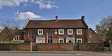
In 1603, Thomas Knyvet was granted the manor of Stanwell. Knyvet was the man who arrested Guy Fawkes in his attempt to blow up the Houses of Parliament. In 1607 he was created Lord Knyvet, and in his will he left money to found a free school in Stanwell, which was established in 1624.[4] The building is no longer a school and now belongs to a housing association. It is Grade II* listed.[5]
James VI and I's infant daughter Mary died at Stanwell, while in the care of the Knyvet household. Several members of the aristocracy lived there in the 17th and 18th centuries. The Cox's Orange Pippin was first grown c. 1830 by Richard Cox in his garden on the Bath Road within the parish, see Colnbrook which now has this piece of land.[3]
In 1838 an unknown species of rose was found in a local garden and given the name of Stanwell Perpetual.
Until 1792 Hounslow Heath extended over the area north of Bedfont Road, and a strip of moorland (Borough Green and Spout Moor) along the present Spout Lane joined it to Hither Moor and Farther Moor, which stretched towards Staines Moor. There were lammas lands in the far east and elsewhere and meadows along many of the river banks, particularly in the north, but the remainder of the parish was largely arable land. Nearly all the land west of Stanwell Moor's clustered centre and that around Hammonds Farm was enclosed by the mid-18th century. Borough Field, to the north and west of the manor-house, and another small field nearby were inclosed in 1771 by the lord of the manor. Most of the area south of Stanwell and West Bedfont villages remained open until 1792 on their enclosure.[3]
By the 18th century, the remaining common land was generally known as Stanwell Field or Town Field before its enclosure. Orchards and market gardens began to spread over the parish in the second half of the 19th century. In 1884 the Staines and West Drayton Railway (now closed) was opened, with Colnbrook railway station in Stanwell parish at Poyle, after the then neighbouring village. The streets of small houses behind the southwest Crooked Billet roundabout (named after a demolished pub) were built in the 1880s. As a community, they formed part of Staines and were transferred to it officially in 1896.
The Staines Union Workhouse was built on the London Road in the mid-19th century. Together with a former boys' home and a former isolation hospital, both opened about 1913, it became Ashford Hospital. Two cemeteries were opened near the A30 between 1895 and 1910. The Staines Reservoirs were completed in 1902 and started supplying water to London in 1904. Between them they cover 440 acres (180 ha).
The two old settlements grew slightly, notably by the building of council housing estates in Stanwell in 1919 and in Stanwell Moor in 1930. A private motor-bus served the village by 1926 and London Transport buses began in 1932. Poyle Halt on the defunct railway opened in 1927 and Poyle Industrial Estate Halt in 1953. After the Second World War, housing society and council house building began including 300 pre-fabricated homes. From 1930, having formed part of a 19th-century Sanitary District then Rural District, Stanwell was administered by an urban district of Middlesex until its 1974 dissolution. In 1965[6] were it not for special provision Stanwell would have seceded with the rest of Middlesex to London: the Staines, Sunbury and Potters Bar Urban Districts transferred variously to Surrey and Hertfordshire, the most distant parts of the county from London.[3]
On Heathrow's construction
In the northwest of the parish, off Spout Lane, Middlesex County Council established 24 small holdings in the early 1930s: Burrows Hill Close estate and Bedfont Court. In 1948 the part of Stanwell New Road north of Park Road opened as a main north-south route. In 1949 most of the former Hounslow Heath land to the north-east, predominantly in Harmondsworth, became London Airport. The east end of the local road to Bedfont was diverted, and the roads running north turned over, together with the eastern half of Spout Lane, where houses were demolished.[3]
In 2004 the village of Stanwell won a Bronze Medal in the national Britain in Bloom[7] competition, in the urban community category.
Notable buildings

Parish church
The Church of England parish church of St Mary the Virgin[8] is a Norman building with a 14th-century Gothic chancel and 15th-century Perpendicular Gothic west tower. The tower has a spire with wood shingles. Inside the church are monuments to members of the Knyvet(t) family who bought Staines manor after their foiling of the planting of the gunpowder and Fawkes.
The church was restored in 1862 under the direction of Samuel Sanders Teulon, and restored again in 1903. The building is Grade I listed.[9]
Stanwell Place
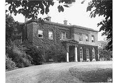
Stanwell Place was a grand manor house from the 17th century 0.5 miles (0.80 km) west of the village church, north of Park Road.[10] The Gibbons family owned the manorial rights from 1754 to 1933,[3][11] and slowly sold off the estate from the 1800s. Sold to John Watson Gibson in 1933, four years later 330 acres (1.3 km2) were sold off to the Metropolitan Water Board for the development of the King George VI Reservoir, now in Staines. After Gibson's death in 1947, Stanwell Place was sold to King Faisal II of Iraq who owned it until his assassination in 1958.[11] The estate was then purchased for gravel extraction, and despite local attempts to prevent it, the house was allowed to become derelict, and demolished in the 1960s.
Economy
What was the north of the parish is a major industrial, distribution and headquarters zone, bound up now in the broad expression 'the M4 corridor'. There was little building in the parish before World War I. The first factory/warehouse at Poyle appeared before 1914 another at West Bedfont in the 1920s. By 1956 there were between 70 and 80 at Poyle, and several at West Bedfont. During the 1920s and 1930s ribbon development spread along the main roads: on the A4 Bath Road Colnbrook remains mainly residential. Garages and a few small factories (now motor manufacturer garages and offices) had been built by the 1950s and remain along the A30 London Road,[3] including Del Monte, Ford and Suzuki.
At one time British Mediterranean Airways was headquartered at the Cirrus House within the post town but in the London Borough of Hounslow,[12][13] near Stanwell.[14]
Demography and housing
| Output area | Detached | Semi-detached | Terraced | Flats and apartments | Caravans/temporary/mobile homes | Shared between households[1] |
|---|---|---|---|---|---|---|
| Stanwell[1] | 332 | 1,602 | 1,257 | 1,316 | 5 | 36 |
The average level of accommodation in the region composed of detached houses was 28%, the average that was apartments was 22.6%.
| Output area | Population | Households | % Owned outright | % Owned with a loan | hectares[1] |
|---|---|---|---|---|---|
| Stanwell[1] | 11,279 | 4,548 | 22.4 | 33.0 | 513 |
The proportion of households in the settlement who owned their home outright compares to the regional average of 35.1%. The proportion who owned their home with a loan compares to the regional average of 32.5%. The remaining % is made up of rented dwellings (plus a negligible % of households living rent-free).
Notable residents
- Thomas Knyvet, 1st Baron Knyvet, Member of Parliament in 1601, was granted the manor of Stanwell for uncovering the Gunpowder Plot in 1603
- Nicholas Hilliard, painter, leased Poyle Manor
- James Nares, English organist and composer, was born in Stanwell in 1715 and married Teresa Costello[15]
- Richard Cox, British horticulturist, created Cox's Orange Pippin apple, first grown in his garden on the Bath Road
- Sir John Watson Gibson, civil engineer, lived in Stanwell Lodge and then Stanwell Place between the 1920s and his death in 1947[16] Since 2015, one of the town's pubs has borne his name[17]
- Sir Allen Lane, the founder of Penguin Books, lived at Silverbeck, Stanwell Moor[18]
- King Faisal II of Iraq owned Stanwell Place from 1948 until his assassination in 1958[11]
- Gary Numan, singer, was raised in Stanwell and attended Abbotsford School
- Pete Shaw, author and theatrical producer, was raised in Short Lane, Stanwell
- Vonn Ströpp, surrealist painter born in Stanwell in 1962
See also
- Middlesex
- Stanwell Park, New South Wales
References
- 1 2 3 4 5 Key Statistics; Quick Statistics: Population Density United Kingdom Census 2011 Office for National Statistics Stanwell makes up 2011 lower output areas Spelthorne 001 and 001 with suffixes A, B and C. Note: the towns and villages in Spelthorne have one ward each which covers part of a neighbouring town or village. For example, Ashford is two wards and part of a third ward (see Government). Retrieved 21 November 2013
- ↑ Surrey Domesday Book Archived 15 July 2007 at the Wayback Machine.
- 1 2 3 4 5 6 7 Stanwell: Introduction Reynolds 1962, pp. 33–36
- ↑ Stanwell: Scoools Reynolds 1962, pp. 49–50
- ↑ Historic England. "Lord Knyvett's Adult Education Centre (Grade II*) (1204896)". National Heritage List for England. Retrieved 15 April 2017.
- ↑ London Government Act 1963
- ↑ RHS Britain in Bloom Results 2004 Archived 9 February 2007 at the Wayback Machine.
- ↑ Archbishops' Council. "St Mary the Virgin, Stanwell, Stanwell". A Church Near You. Church of England. Retrieved 15 December 2013.
- ↑ Historic England. "Church of St Mary (Grade I) (1187042)". National Heritage List for England. Retrieved 15 December 2013.
- ↑ Google. "Location of Stanwell Place" (Map). Google Maps. Google.
- 1 2 3 Stanwell: Manors Reynolds 1962, pp. 36–41
- ↑ "Contact." British Mediterranean Airways. 10 December 2004. Retrieved on 21 November 2011. "BMED Cirrus House, Bedfont Road London Heathrow Airport Staines, Middlesex TW19 7NL, UK "
- ↑ "FAQ's -> How can I find out about employment opportunities with BMed?." British Mediterranean Airways. 12 February 2004. Retrieved on 21 November 2011. "Please write to us at : British Mediterranean Airways Human Resources Manager Cirrus House Bedfont Road London Heathrow Airport Staines Middlesex TW19 7NL England"
- ↑ "Reference to Planning Application – 10/03822/LB regarding the same site Archived 25 April 2012 at the Wayback Machine.." London Borough of Croydon. Retrieved on 21 November 2011. "Amey Built Environment Cirrus House Bedfont Road Stanwell Middlesex TW19 7NL"
- ↑ The American History and Encyclopedia of Music
- ↑

|access-date=requires|url=(help) - ↑ "Sir John Gibson, Stanwell". What Pub?. Campaign for Real Ale. Retrieved 6 March 2016.
- ↑ "Penguin Special Archive highlights". Archive Project. University of Bristol. Archived from the original on 8 March 2010.
Sources
- Reynolds, Susan, ed. (1962). A History of the County of Middlesex. Victoria County History. III. London: Oxford University Press for the Institute of Historical Research. pp. 33–50.