Lenvik
| Lenvik kommune Leaŋgáviika suohkan | |||
|---|---|---|---|
| Municipality | |||
 View of Finnsnes | |||
| |||
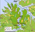
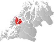 Lenvik within Troms | |||
| Coordinates: 69°23′01″N 17°58′03″E / 69.38361°N 17.96750°ECoordinates: 69°23′01″N 17°58′03″E / 69.38361°N 17.96750°E | |||
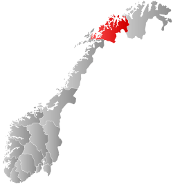
| Country | Norway | ||
| County | Troms | ||
| District | Midt-Troms | ||
| Established | 1 Jan 1838 | ||
| Administrative centre | Finnsnes | ||
| Government | |||
| • Mayor (2011) | Geir-Inge Sivertsen (H) | ||
| Area | |||
| • Total | 892.69 km2 (344.67 sq mi) | ||
| • Land | 848.88 km2 (327.75 sq mi) | ||
| • Water | 43.81 km2 (16.92 sq mi) 5% | ||
| Area rank | #126 in Norway | ||
| Population (2017) | |||
| • Total | 11,697 | ||
| • Rank | #100 in Norway | ||
| • Density | 13.8/km2 (36/sq mi) | ||
| • Change (10 years) | 6.1% | ||
| Demonym(s) | Lenvikværing[1] | ||
| Time zone | UTC+01:00 (CET) | ||
| • Summer (DST) | UTC+02:00 (CEST) | ||
| ISO 3166 code | NO-1931 | ||
| Official language form | Neutral | ||
| Website |
lenvik | ||
Lenvik (Northern Sami: Leaŋgáviika) is a municipality in Troms county, Norway. The municipality is partly situated on the mainland, partly on the island of Senja. The administrative centre is the town of Finnsnes, where the Gisund Bridge connects Senja to the mainland on Norwegian County Road 86. Other villages in the municipality include Aglapsvik, Gibostad, Botnhamn, Fjordgård, Finnfjordbotn, Husøy, Langnes, Laukhella, Silsand, and Rossfjordstraumen. The lake Lysvatnet is located on Senja island, west of Gibostad.
The 893-square-kilometre (345 sq mi) municipality is the 126th largest by area out of the 422 municipalities in Norway. Lenvik is the 100th most populous municipality in Norway with a population of 11,697. The municipality's population density is 13.8 inhabitants per square kilometre (36/sq mi) and its population has increased by 6.1% over the last decade.[2]
General information
The large municipality of Lenvik was established on 1 January 1838 (see formannskapsdistrikt). In 1848, most of the mainland parts of Lenvik (population: 2,616) was separated to form the new Målselv Municipality, leaving Lenvik with 3,029 residents. Then in 1855, the northern part of Lenvik (population: 811) was separated to form the new municipality of Hillesøy. This left Lenvik with 2,757 inhabitants. On 1 January 1871, a small part of Lenvik (population: 70) was transferred to the neighboring municipality of Malangen.
During the 1960s, there were many municipal mergers across Norway due to the work of the Schei Committee. On 1 January 1964, many several neighboring areas were merged into Lenvik:[3]
- the part of Sørreisa Municipality on the island of Senja (population: 129)
- the Hellemo, Paulsrud, Johnsgård, and Stormo farms in Tranøy Municipality (population: 106)
- the part of Hillesøy Municipality on the island of Senja and the whole island of Hekkingen (population: 1,159)
These areas joined to old areas of Lenvik to form a new, larger municipality of Lenvik with a total population of 10,219.
In March 2017, the Parliament of Norway voted to merge the municipalities of Berg, Torsken, Lenvik, and Tranøy. The new municipality will encompass the whole island of Senja plus part of the mainland located between the Gisundet strait and the Malangen fjord. The new municipality will be established on 1 January 2020 and it will be called Senja Municipality.[4][5]
Name
The municipality (originally the parish) is named after the old Lenvik farm (Old Norse: Lengjuvík), since the first Lenvik Church was built there. The first element is the genitive case of the river name Lengja and the last element is vík which means "cove" or "wick". The river name is derived from the word langr which means "long". From 1889-1908, the name was spelled Lenviken.[6]
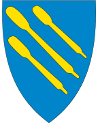
Coat of arms
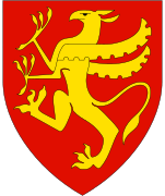
The coat of arms is from modern times; they were granted on 22 August 1986. The arms show three gold oars on a blue background. The oars and color blue are a symbol for the fishing and sailing in the municipality. To distinguish the arms from those from many other fishing towns, the oar was chosen as a symbol.[7]
Churches
The Church of Norway has one parish (sokn) within the municipality of Lenvik. It is part of the Senja prosti (deanery) in the Diocese of Nord-Hålogaland.
| Parish (Sokn) | Church Name | Location of the Church | Year Built |
|---|---|---|---|
| Lenvik | Finnsnes Church | Finnsnes | 1979 |
| Lenvik Church | Bjorelvnes | 1879 | |
| Rossfjord Church | Rossfjordstraumen | 1822 | |
| Fjordgård Chapel | Fjordgård | 1976 | |
| Gibostad Chapel | Gibostad | 1939 | |
| Husøy Chapel | Husøy i Senja | 1957 | |
| Lysbotn Chapel | Lysnes | 1970 | |
| Sandbakken Chapel | Sandbakken | 1974 |
History
The first church was built around 1150 at Bjorelvnes, and for a century, this was the northernmost church in the world. Important villages in the past include Klauva and Gibostad. Gibostad was the administrative centre until the 1960s, when the administration was moved to Finnsnes. In 2000, Finnsnes was declared a town.
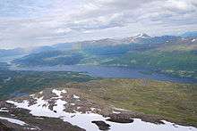
Geography
The municipality of Lenvik lies partly on the island of Senja and also on the mainland of Norway. The Malangen fjord flows along the northern boundary and the Solbergfjorden lies on the southern boundary. The Gisundet strait runs north-south through the center of the municipality with only one road crossing, the Gisund Bridge. The municipalities of Berg and Tranøy border the municipality to the west, the municipality of Tromsø is to the north (across the Malangen fjord), the municipalities of Balsfjord and Målselv are to the east, and the municipalities of Sørreisa and Dyrøy are to the south.
Climate
| Climate data for Gibostad, Lenvik | |||||||||||||
|---|---|---|---|---|---|---|---|---|---|---|---|---|---|
| Month | Jan | Feb | Mar | Apr | May | Jun | Jul | Aug | Sep | Oct | Nov | Dec | Year |
| Average high °C (°F) | −1.9 (28.6) |
−1.8 (28.8) |
0.2 (32.4) |
3.6 (38.5) |
8.4 (47.1) |
12.9 (55.2) |
15.0 (59) |
14.6 (58.3) |
10.5 (50.9) |
5.8 (42.4) |
1.5 (34.7) |
−0.7 (30.7) |
5.7 (42.3) |
| Daily mean °C (°F) | −4.4 (24.1) |
−4.2 (24.4) |
−2.3 (27.9) |
1.0 (33.8) |
5.5 (41.9) |
9.7 (49.5) |
12.3 (54.1) |
11.6 (52.9) |
7.5 (45.5) |
3.3 (37.9) |
−0.8 (30.6) |
−3.2 (26.2) |
3.0 (37.4) |
| Average low °C (°F) | −7.1 (19.2) |
−7.0 (19.4) |
−5.5 (22.1) |
−2.1 (28.2) |
2.5 (36.5) |
6.8 (44.2) |
9.1 (48.4) |
8.3 (46.9) |
5.1 (41.2) |
1.3 (34.3) |
−3.1 (26.4) |
−5.8 (21.6) |
0.2 (32.4) |
| Average precipitation mm (inches) | 85 (3.35) |
80 (3.15) |
60 (2.36) |
54 (2.13) |
39 (1.54) |
47 (1.85) |
62 (2.44) |
71 (2.8) |
91 (3.58) |
119 (4.69) |
94 (3.7) |
98 (3.86) |
900 (35.43) |
| Average precipitation days (≥ 1 mm) | 13.4 | 12.4 | 11.5 | 10.7 | 9.2 | 10.6 | 13.2 | 12.4 | 14.3 | 16.0 | 14.7 | 15.6 | 154.0 |
| Source: Norwegian Meteorological Institute[8] | |||||||||||||
Government
All municipalities in Norway, including Lenvik, are responsible for primary education (through 10th grade), outpatient health services, senior citizen services, unemployment and other social services, zoning, economic development, and municipal roads. The municipality is governed by a municipal council of elected representatives, which in turn elect a mayor.[9] The municipality falls under the Senja District Court and the Hålogaland Court of Appeal.
Municipal council
The municipal council (Kommunestyre) of Lenvik is made up of 31 representatives that are elected to four year terms. Currently, the party breakdown is as follows:[10]
| Party Name | Name in Norwegian | Number of representatives | |
|---|---|---|---|
| Labour Party | Arbeiderpartiet | 8 | |
| Progress Party | Fremskrittspartiet | 4 | |
| Conservative Party | Høyre | 7 | |
| Christian Democratic Party | Kristelig Folkeparti | 2 | |
| Centre Party | Senterpartiet | 3 | |
| Socialist Left Party | Sosialistisk Venstreparti | 2 | |
| Liberal Party | Venstre | 1 | |
| Local Lists | Lokale lister | 4 | |
| Total number of members: | 31 | ||
Media gallery
 Lenvik includes part of the mainland and eastern part of Senja
.jpg) View from Gibostad village on Senja island towards Kistefjellet mountain on the mainland
View from Gibostad village on Senja island towards Kistefjellet mountain on the mainland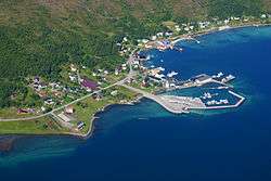 View of Botnhamn
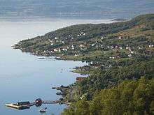 View of Trollvik
References
- ↑ "Navn på steder og personer: Innbyggjarnamn" (in Norwegian). Språkrådet. Retrieved 2015-12-01.
- ↑ Statistisk sentralbyrå (2017). "Table: 06913: Population 1 January and population changes during the calendar year (M)" (in Norwegian). Retrieved 2017-09-09.
- ↑ Jukvam, Dag (1999). "Historisk oversikt over endringer i kommune- og fylkesinndelingen" (PDF) (in Norwegian). Statistisk sentralbyrå.
- ↑ "Senja kommune 2020" (in Norwegian). Retrieved 2017-09-09.
- ↑ Vermes, Thomas (2017-03-29). "Stortingsflertallet gjør fire Senja-kommuner til én". ABC Nyheter (in Norwegian). Retrieved 2017-09-09.
- ↑ Rygh, Oluf (1911). Norske gaardnavne: Troms amt (in Norwegian) (17 ed.). Kristiania, Norge: W. C. Fabritius & sønners bogtrikkeri. p. 90.
- ↑ "Civic heraldry of Norway - Norske Kommunevåpen". Heraldry of the World. Retrieved 2018-08-25.
- ↑ "eKlima Web Portal". Norwegian Meteorological Institute. Archived from the original on 2004-06-14.
- ↑ Hansen, Tore, ed. (2016-05-12). "kommunestyre". Store norske leksikon (in Norwegian). Kunnskapsforlaget. Retrieved 2018-08-25.
- ↑ "Table: 04813: Members of the local councils, by party/electoral list at the Municipal Council election (M)" (in Norwegian). Statistics Norway.
External links
- Municipal fact sheet from Statistics Norway (in Norwegian)


| |||||||||
| |||||||||
| |||||||||
| Authority control |
|---|