Sørreisa
| Sørreisa kommune Ráisavuona suohkan | |||
|---|---|---|---|
| Municipality | |||
| |||
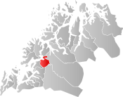 Sørreisa within Troms | |||
| Coordinates: 69°05′31″N 18°11′37″E / 69.09194°N 18.19361°ECoordinates: 69°05′31″N 18°11′37″E / 69.09194°N 18.19361°E | |||
| Country | Norway | ||
| County | Troms | ||
| District | Midt-Troms | ||
| Established | 1 Sept 1886 | ||
| Administrative centre | Sørreisa | ||
| Government | |||
| • Mayor (2015) | Jan-Eirik Nordahl (Ap) | ||
| Area | |||
| • Total | 361.17 km2 (139.45 sq mi) | ||
| • Land | 346.91 km2 (133.94 sq mi) | ||
| • Water | 14.26 km2 (5.51 sq mi) 4% | ||
| Area rank | #255 in Norway | ||
| Population (2017) | |||
| • Total | 3,496 | ||
| • Rank | #247 in Norway | ||
| • Density | 10.1/km2 (26/sq mi) | ||
| • Change (10 years) | 5.5% | ||
| Demonym(s) | Sørreisværing[1] | ||
| Time zone | UTC+01:00 (CET) | ||
| • Summer (DST) | UTC+02:00 (CEST) | ||
| ISO 3166 code | NO-1925 | ||
| Official language form | Neutral | ||
| Website |
sorreisa | ||
Sørreisa (Northern Sami: Ráisavuona suohkan) is a municipality in Troms county, Norway. The administrative centre of the municipality is the village of Sørreisa. Other villages include Grunnreisa, Skøelva, and Smørsgård.
The 361-square-kilometre (139 sq mi) municipality is the 255th largest by area out of the 422 municipalities in Norway. Sørreisa is the 247th most populous municipality in Norway with a population of 3,496. The municipality's population density is 10.1 inhabitants per square kilometre (26/sq mi) and its population has increased by 5.5% over the last decade.[2]
General information

The municipality of Sørreisen was established on 1 September 1886 when the large Tranøy Municipality was divided into three: Tranøy (population: 1,239) in the west, Dyrøy (population: 1,281) in the south, and Sørreisen (population: 1,361) in the east. Later, the spelling was changed to Sørreisa. During the 1960s, there were many municipal mergers across Norway due to the work of the Schei Committee. On 1 January 1964, the part of Sørreisa across the Reisafjorden on the island of Senja (population: 129) was transferred to Lenvik Municipality.[3]
Name
The municipality is named after the Reisafjorden (originally Reisa), which again is named after the Reisaelva (the "Reisa river" - originally Reisa). The river name is derived from the verb rísa which means "raise" (referring to flooding). The first element Sør ("south") was added to distinguish the municipality from Nordreisa Municipality (located further to the north in the same county). The municipality was originally named Sørreisen.[4]
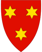
Coat of arms
The coat of arms is from modern times; they were granted on 7 September 1984. The arms show three gold stars on a red background. It was derived from the oldest known seal in the municipality, a 17th-century seal of Jacob Hansen Kinapel, who was a police sergeant in Sørreisa from 1715 to 1748.[5]
Churches
The Church of Norway has one parish (sokn) within the municipality of Sørreisa. It is part of the Indre Troms prosti (deanery) in the Diocese of Nord-Hålogaland.
| Parish (Sokn) | Church Name | Location of the Church | Year Built |
|---|---|---|---|
| Sørreisa | Sørreisa Church | Tømmervika | 1992 |
| Skøelv Chapel | Skøelva | 1966 | |
| Straumen Chapel | Sørreisa | 1973 |
Geography
Sørreisa is located on the western coast of Norway, along the Reisafjorden, just east of the large island of Senja. The 363-square-kilometre (140 sq mi) municipality is mostly populated along the shoreline. The municipality of Dyrøy lies to the west, Salangen and Bardu to the south, Målselv to the east, and Lenvik to the north.
Climate
| Climate data for Sørreisa | |||||||||||||
|---|---|---|---|---|---|---|---|---|---|---|---|---|---|
| Month | Jan | Feb | Mar | Apr | May | Jun | Jul | Aug | Sep | Oct | Nov | Dec | Year |
| Daily mean °C (°F) | −4.5 (23.9) |
−4.3 (24.3) |
−2.3 (27.9) |
1.0 (33.8) |
5.9 (42.6) |
10.2 (50.4) |
12.7 (54.9) |
11.5 (52.7) |
7.4 (45.3) |
3.4 (38.1) |
−0.8 (30.6) |
−3.1 (26.4) |
3.1 (37.6) |
| Average precipitation mm (inches) | 97 (3.82) |
86 (3.39) |
67 (2.64) |
56 (2.2) |
39 (1.54) |
50 (1.97) |
66 (2.6) |
74 (2.91) |
92 (3.62) |
122 (4.8) |
103 (4.06) |
103 (4.06) |
955 (37.6) |
| Source: Norwegian Meteorological Institute[6] | |||||||||||||
Government
All municipalities in Norway, including Sørreisa, are responsible for primary education (through 10th grade), outpatient health services, senior citizen services, unemployment and other social services, zoning, economic development, and municipal roads. The municipality is governed by a municipal council of elected representatives, which in turn elect a mayor.[7] The municipality falls under the Senja District Court and the Hålogaland Court of Appeal.
Municipal council
The municipal council (Kommunestyre) of Sørreisa is made up of 15 representatives that are elected to four year terms. Currently, the party breakdown is as follows:[8]
| Party Name | Name in Norwegian | Number of representatives | |
|---|---|---|---|
| Labour Party | Arbeiderpartiet | 7 | |
| Progress Party | Fremskrittspartiet | 1 | |
| Conservative Party | Høyre | 2 | |
| Centre Party | Senterpartiet | 1 | |
| Local Lists | Lokale lister | 4 | |
| Total number of members: | 15 | ||
References
- ↑ "Navn på steder og personer: Innbyggjarnamn" (in Norwegian). Språkrådet. Retrieved 2015-12-01.
- ↑ Statistisk sentralbyrå (2017). "Table: 06913: Population 1 January and population changes during the calendar year (M)" (in Norwegian). Retrieved 2017-09-09.
- ↑ Jukvam, Dag (1999). "Historisk oversikt over endringer i kommune- og fylkesinndelingen" (PDF) (in Norwegian). Statistisk sentralbyrå.
- ↑ Rygh, Oluf (1911). Norske gaardnavne: Troms amt (in Norwegian) (17 ed.). Kristiania, Norge: W. C. Fabritius & sønners bogtrikkeri. p. 62.
- ↑ "Civic heraldry of Norway - Norske Kommunevåpen". Heraldry of the World. Retrieved 2018-08-26.
- ↑ "eKlima Web Portal". Norwegian Meteorological Institute. Archived from the original on 2004-06-14.
- ↑ Hansen, Tore, ed. (2016-05-12). "kommunestyre". Store norske leksikon (in Norwegian). Kunnskapsforlaget. Retrieved 2018-08-25.
- ↑ "Table: 04813: Members of the local councils, by party/electoral list at the Municipal Council election (M)" (in Norwegian). Statistics Norway.
External links
- Municipal fact sheet from Statistics Norway (in Norwegian)


| |||||||||
| |||||||||
| |||||||||
| Authority control |
|---|