Senja
| Senja kommune | ||
|---|---|---|
| Municipality | ||
| ||
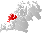 Senja within Troms | ||
| Coordinates: 69°04′50″N 16°48′11″E / 69.0806°N 16.8031°ECoordinates: 69°04′50″N 16°48′11″E / 69.0806°N 16.8031°E | ||
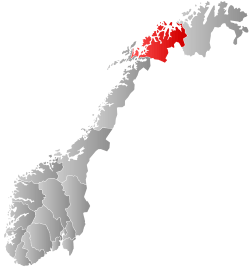
| Country | Norway | |
| County | Troms | |
| District | Hålogaland | |
| Established | 1 Jan 2020 | |
| Administrative centre | Finnsnes | |
| Area | ||
| • Total | 1,953.87 km2 (754.39 sq mi) | |
| • Land | 1,859.79 km2 (718.07 sq mi) | |
| • Water | 94.08 km2 (36.32 sq mi) 4.8% | |
| Population (2017) | ||
| • Total | 15,072 | |
| • Density | 7.7/km2 (20/sq mi) | |
| Demonym(s) |
Senjaværing Senjeværing[1] | |
| Time zone | UTC+01:00 (CET) | |
| • Summer (DST) | UTC+02:00 (CEST) | |
| ISO 3166 code | NO-5421 | |
| Website |
senja2020 | |
Senja is a future municipality in Troms county, Norway. It is going to be established on 1 January 2020 when the municipalities of Berg, Lenvik, Torsken, and Tranøy are merged into one municipality. It is located in the traditional district of Hålogaland. The administrative centre of the municipality will be the town of Finnsnes. The municipality will include all of the island of Senja, the smaller surrounding islands, and part of the mainland between the Gisundet strait and the Malangen fjord.[2]
General information
In March 2017, the Parliament of Norway voted to merge the municipalities of Berg, Torsken, Lenvik, and Tranøy. The new municipality will be established on 1 January 2020 as Senja Municipality (Norwegian: Senja kommune).[3][4]
Name
The Old Norse form of the name must also have been Senja or perhaps Sændja. The meaning of the name is unknown, but it might be related to the verb sundra which means to "tear" or "split apart", possibly because the west coast of the island is torn and split by numerous small fjords. It might also be derived from a Proto-Norse form of the word Sandijōn meaning "(area) of sand" or "sandy island".[5][2]
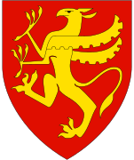
Coat of arms
The coat of arms is going to be blue with a white outline of the Okshornan mountain with a green depiction of the northern lights above the mountain.[6]
Geography
The island of Senja is located along the Troms county coastline with Finnsnes as the closest town. Senja is connected to the mainland by the Gisund Bridge. The municipalities located on Senja are Lenvik (part of which is on the mainland), Berg, Torsken, and Tranøy.[2]
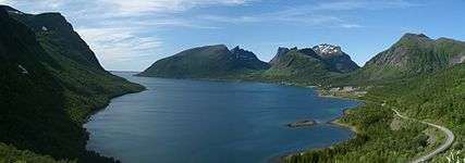
The northern coasts of Senja faces the open sea, the western coast faces the islands of Andøya and Krøttøya, the southern coast faces the islands of Andørja and Dyrøya. On the western coast, steep and rugged mountains rise straight from the sea, with some fishing villages (like Gryllefjord, Husøy) tucked into the small lowland areas between the mountains and the sea. The eastern and southern parts of the island are milder, with rounder mountains, forests, rivers and agriculture land.
Senja is often referred to as "Norway in miniature", as the island's diverse scenery reflects almost the entire span of Norwegian nature. Senja is well known domestically for its beautiful scenery, and is marketed as a tourist attraction.
Climate
Climate data from the village of Gibostad on the eastern shore of the island, facing the mainland during the base period of 1961-1990. The western side of the island, facing the Norwegian Sea, will have slightly milder but more windy winters.
| Climate data for Gibostad, Lenvik | |||||||||||||
|---|---|---|---|---|---|---|---|---|---|---|---|---|---|
| Month | Jan | Feb | Mar | Apr | May | Jun | Jul | Aug | Sep | Oct | Nov | Dec | Year |
| Average high °C (°F) | −1.9 (28.6) |
−1.8 (28.8) |
0.2 (32.4) |
3.6 (38.5) |
8.4 (47.1) |
12.9 (55.2) |
15.0 (59) |
14.6 (58.3) |
10.5 (50.9) |
5.8 (42.4) |
1.5 (34.7) |
−0.7 (30.7) |
5.7 (42.3) |
| Daily mean °C (°F) | −4.4 (24.1) |
−4.2 (24.4) |
−2.3 (27.9) |
1.0 (33.8) |
5.5 (41.9) |
9.7 (49.5) |
12.3 (54.1) |
11.6 (52.9) |
7.5 (45.5) |
3.3 (37.9) |
−0.8 (30.6) |
−3.2 (26.2) |
3.0 (37.4) |
| Average low °C (°F) | −7.1 (19.2) |
−7.0 (19.4) |
−5.5 (22.1) |
−2.1 (28.2) |
2.5 (36.5) |
6.8 (44.2) |
9.1 (48.4) |
8.3 (46.9) |
5.1 (41.2) |
1.3 (34.3) |
−3.1 (26.4) |
−5.8 (21.6) |
0.2 (32.4) |
| Average precipitation mm (inches) | 85 (3.35) |
80 (3.15) |
60 (2.36) |
54 (2.13) |
39 (1.54) |
47 (1.85) |
62 (2.44) |
71 (2.8) |
91 (3.58) |
119 (4.69) |
94 (3.7) |
98 (3.86) |
900 (35.43) |
| Average precipitation days (≥ 1 mm) | 13.4 | 12.4 | 11.5 | 10.7 | 9.2 | 10.6 | 13.2 | 12.4 | 14.3 | 16.0 | 14.7 | 15.6 | 154.0 |
| Source: Norwegian Meteorological Institute[7] | |||||||||||||
Attractions
Among the sights of the island are Ånderdalen National Park with coastal pine forests and mountains,[8] traditional fishing communities, and the Senja Troll, the world's largest troll. The southernmost municipality Tranøy also has several small museums documenting local history, among these the Halibut Museum ("Kveitmuseet") in Skrolsvik.
Media gallery
- Photos of Senja
 Bergsfjorden, Senja
 Husøy, Northern Senja
 View from a ridge between Segla and Hesten, Senja, Norway,
.jpg) View from Gibostad towards Kistefjellet on the mainland
View from Gibostad towards Kistefjellet on the mainland.jpg) Seashore on the Senja island in Norway
Seashore on the Senja island in Norway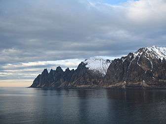 Ersfjorden and near mountains
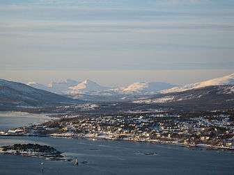
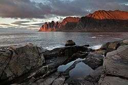
 Okshornan peaks viewed from Tungeneset
References
- ↑ "Navn på steder og personer: Innbyggjarnamn" (in Norwegian). Språkrådet. Retrieved 2015-12-01.
- 1 2 3 Thorsnæs, Geir, ed. (2018-05-09). "Senja". Store norske leksikon (in Norwegian). Kunnskapsforlaget. Retrieved 2018-08-25.
- ↑ "Senja kommune 2020" (in Norwegian). Retrieved 2017-09-09.
- ↑ Vermes, Thomas (2017-03-29). "Stortingsflertallet gjør fire Senja-kommuner til én". ABC Nyheter (in Norwegian). Retrieved 2017-09-09.
- ↑ "Bidrag till Fennoskandiens språkliga förhistoria i tid och rum" (PDF) (in Swedish). Helsingfors Universitet. Retrieved 2015-12-27.
- ↑ Henriksen, Steinulf (2018-05-25). "Det viktigste Senja-våpen". Folkebladet (in Norwegian). Retrieved 2018-08-25.
- ↑ "eKlima Web Portal". Norwegian Meteorological Institute. Archived from the original on 2004-06-14.
- ↑ "Ånderdalen National Park" (in Norwegian). Directorate for nature management. Retrieved 2010-04-04.
| |||||||||
| |||||||||
| |||||||||